Difference between revisions of "2010-09-13 55 14"
imported>Fasanen (Created page with '{{subst:Expedition |lat = 55 |lon = 14 |date = 2010-09-13 }}') |
imported>Fasanen |
||
| Line 1: | Line 1: | ||
| − | |||
| − | |||
| − | |||
| − | |||
| − | |||
| − | |||
| − | |||
| − | |||
| − | |||
| − | |||
{{meetup graticule | {{meetup graticule | ||
| lat=55 | | lat=55 | ||
| Line 15: | Line 5: | ||
}} | }} | ||
| − | |||
__NOTOC__ | __NOTOC__ | ||
== Location == | == Location == | ||
| − | + | In a field just south of Glemmingebro, Sweden. | |
== Participants == | == Participants == | ||
| − | + | * [[User:Fasanen|Fasanen]] | |
== Plans == | == Plans == | ||
| − | + | Deflower the graticule at midnight. | |
== Expedition == | == Expedition == | ||
| − | + | Today's location seemed ideal for trying to deflower 55 14. I had no time to go here during the day, so I decided to try a midnight hash. Google maps indicated farm land which with a bit of luck should have been recently harvested. There also seemed to be some farm houses between the main road and the hash. The prospect of having to describe geohashing in the middle of the night to a suspicious farmer with a shotgun and a drooling dog was not exciting so I planned for not taking the shortest path to the hash. | |
| + | |||
| + | I parked the car where the road crossed the "Norre å" stream and walked alongside it until I got to a fallow field. It was very dark but I had a good head lamp. I turned south and kept distance to the houses. Luckily the field where the hash point was had recently been harvested and was easy to walk. | ||
| + | |||
| + | I got to the coordinates well in time before midnight and had to wait there until I could get photographs of my GPS devices showing the correct time. There was not much to do alone in the darkness. I tried the Google Sky application but after a few minutes, clouds gathered and obscured the starry sky. Web surfing and mail reading occupied me until midnight and I could take the pictures. | ||
| − | + | While waiting in the dark field, I completely lost my sense of direction. When it was time to return, I began waking in the direction which I was convinced was north. I could not believe my eyes when the GPS indicated that I was southbound. After finally correcting my course, I tracked back and got home at 00.50. --[[User:Fasanen|Fasanen]] 08:21, 13 September 2010 (UTC) | |
| − | |||
== Photos == | == Photos == | ||
| − | < | + | <gallery perrow="4"> |
| − | Image: | + | Image:551420100913 01.JPG | The hash |
| − | + | Image:551420100913 02.JPG | Proof | |
| − | + | Image:551420100913 03.JPG | Happy hasher | |
| + | Image:551420100913 04.JPG | Light in the dark | ||
</gallery> | </gallery> | ||
| Line 43: | Line 36: | ||
<!-- Add any achievement ribbons you earned below, or remove this section --> | <!-- Add any achievement ribbons you earned below, or remove this section --> | ||
| − | |||
| − | |||
| − | |||
| − | |||
| − | |||
| − | |||
| − | |||
| − | |||
| − | |||
| − | |||
| − | |||
[[Category:Expeditions]] | [[Category:Expeditions]] | ||
| − | |||
[[Category:Expeditions with photos]] | [[Category:Expeditions with photos]] | ||
| − | |||
| − | |||
| − | |||
| − | |||
| − | |||
[[Category:Coordinates reached]] | [[Category:Coordinates reached]] | ||
| − | |||
| − | |||
| − | |||
| − | |||
| − | |||
| − | |||
| − | |||
| − | |||
| − | |||
| − | |||
Revision as of 08:21, 13 September 2010
| Mon 13 Sep 2010 in 55,14: 55.4423061, 14.0250776 geohashing.info google osm bing/os kml crox |
Location
In a field just south of Glemmingebro, Sweden.
Participants
Plans
Deflower the graticule at midnight.
Expedition
Today's location seemed ideal for trying to deflower 55 14. I had no time to go here during the day, so I decided to try a midnight hash. Google maps indicated farm land which with a bit of luck should have been recently harvested. There also seemed to be some farm houses between the main road and the hash. The prospect of having to describe geohashing in the middle of the night to a suspicious farmer with a shotgun and a drooling dog was not exciting so I planned for not taking the shortest path to the hash.
I parked the car where the road crossed the "Norre å" stream and walked alongside it until I got to a fallow field. It was very dark but I had a good head lamp. I turned south and kept distance to the houses. Luckily the field where the hash point was had recently been harvested and was easy to walk.
I got to the coordinates well in time before midnight and had to wait there until I could get photographs of my GPS devices showing the correct time. There was not much to do alone in the darkness. I tried the Google Sky application but after a few minutes, clouds gathered and obscured the starry sky. Web surfing and mail reading occupied me until midnight and I could take the pictures.
While waiting in the dark field, I completely lost my sense of direction. When it was time to return, I began waking in the direction which I was convinced was north. I could not believe my eyes when the GPS indicated that I was southbound. After finally correcting my course, I tracked back and got home at 00.50. --Fasanen 08:21, 13 September 2010 (UTC)
Photos

The hash
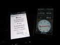
Proof

Happy hasher

Light in the dark


