Difference between revisions of "2010-09-14 45 -73"
imported>Stelei m (→Achievements) |
imported>Benjw (clean up template) |
||
| Line 1: | Line 1: | ||
| − | |||
| − | |||
| − | |||
| − | |||
| − | |||
| − | |||
| − | |||
| − | |||
| − | |||
{{meetup graticule | {{meetup graticule | ||
| lat=45 | | lat=45 | ||
| Line 13: | Line 4: | ||
| date=2010-09-14 | | date=2010-09-14 | ||
}} | }} | ||
| − | |||
| − | |||
__NOTOC__ | __NOTOC__ | ||
== Location == | == Location == | ||
| − | |||
On the shore near Rapides de Cap-Ste-Jacques. | On the shore near Rapides de Cap-Ste-Jacques. | ||
Fortunately near a footpath, so quite easily reachable. | Fortunately near a footpath, so quite easily reachable. | ||
| − | |||
== Participants == | == Participants == | ||
| − | |||
[[User:Stelei|stelei]] | [[User:Stelei|stelei]] | ||
== Plans == | == Plans == | ||
| − | |||
[[User:Stelei|stelei]] planned to reach the geohash in the short time between the end of school (and work) and sundown. This added much excitement to an otherwise boring day. The geohash was to be reached after a relatively painless drive through the city, and a short walk on the path. Clouds and intermittent rain may have caused problems, especially if the footpath turned out to be muddy. | [[User:Stelei|stelei]] planned to reach the geohash in the short time between the end of school (and work) and sundown. This added much excitement to an otherwise boring day. The geohash was to be reached after a relatively painless drive through the city, and a short walk on the path. Clouds and intermittent rain may have caused problems, especially if the footpath turned out to be muddy. | ||
== Expedition == | == Expedition == | ||
| − | |||
[[User:Stelei|stelei]] and her partner reached the geohash! The area was deserted. The car was parked on rue Cap-St-Jacques, close to where the path started, and we set out on foot. The path was in good condition and not muddy at all. We reached the geohash without having to delve into the bushes between the path and the shore, then played on the rocks near the rapids for about an hour. If only we had brought a [[Fly a kite achievement|kite]]... | [[User:Stelei|stelei]] and her partner reached the geohash! The area was deserted. The car was parked on rue Cap-St-Jacques, close to where the path started, and we set out on foot. The path was in good condition and not muddy at all. We reached the geohash without having to delve into the bushes between the path and the shore, then played on the rocks near the rapids for about an hour. If only we had brought a [[Fly a kite achievement|kite]]... | ||
| − | |||
| − | |||
| − | |||
| − | |||
| − | |||
| − | |||
| − | |||
=== [[User:Stelei|stelei]]'s pictures: === | === [[User:Stelei|stelei]]'s pictures: === | ||
<gallery perrow="6"> | <gallery perrow="6"> | ||
| Line 50: | Line 27: | ||
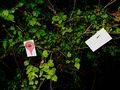
Image:2010-09-14 45 -73 IMG 8511.JPG | The documentation left behind. | Image:2010-09-14 45 -73 IMG 8511.JPG | The documentation left behind. | ||
</gallery> | </gallery> | ||
| − | |||
| − | |||
| − | |||
| − | |||
| − | |||
| − | |||
| − | |||
| − | |||
| − | |||
| − | |||
| − | |||
[[Category:Expeditions]] | [[Category:Expeditions]] | ||
[[Category:Expeditions with photos]] | [[Category:Expeditions with photos]] | ||
| − | |||
| − | |||
| − | |||
| − | |||
| − | |||
| − | |||
[[Category:Coordinates reached]] | [[Category:Coordinates reached]] | ||
| − | |||
| − | |||
| − | |||
| − | |||
| − | |||
| − | |||
| − | |||
| − | |||
| − | |||
Revision as of 08:11, 21 October 2010
| Tue 14 Sep 2010 in 45,-73: 45.4713963, -73.9238315 geohashing.info google osm bing/os kml crox |
Location
On the shore near Rapides de Cap-Ste-Jacques. Fortunately near a footpath, so quite easily reachable.
Participants
Plans
stelei planned to reach the geohash in the short time between the end of school (and work) and sundown. This added much excitement to an otherwise boring day. The geohash was to be reached after a relatively painless drive through the city, and a short walk on the path. Clouds and intermittent rain may have caused problems, especially if the footpath turned out to be muddy.
Expedition
stelei and her partner reached the geohash! The area was deserted. The car was parked on rue Cap-St-Jacques, close to where the path started, and we set out on foot. The path was in good condition and not muddy at all. We reached the geohash without having to delve into the bushes between the path and the shore, then played on the rocks near the rapids for about an hour. If only we had brought a kite...
stelei's pictures:
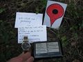
GPS with the day's geohash, watch with the date, and of course a Google Maps pointer!
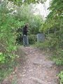
Pinpointing the coordinates.
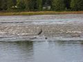
A look of disapproval from a heron.
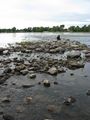
Low waters allowed us to get close to the rapids.
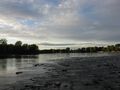
Looking upstream Rivière-des-Prairies.
The documentation left behind.


