Difference between revisions of "2010-09-19 56 14"
imported>Llavids |
imported>FippeBot m (Location) |
||
| (5 intermediate revisions by 2 users not shown) | |||
| Line 13: | Line 13: | ||
== Plans == | == Plans == | ||
| − | When we were in on a trip to Blekinge, we saw that the current | + | When we were in on a trip to Blekinge, we saw that the current geohash would be close up north, so we decided to take an extra trip to visit the place. |
== Expedition == | == Expedition == | ||
| − | Weather was cloudy, just a few drops of rain. We drove as close to the | + | Weather was cloudy, just a few drops of rain. We drove as close to the geohashpoint as possible and parked. Had to walk 140 meters into the forest to find the place. One could see a lot of wild boar activity in the area. Just close to the spot we found a fallen tree that we used as a picnic chair. |
| + | |||
| + | After documenting the place and picnicking, we went back to the car. Unfortunately we forgot our son's shoes and it was too far away when we recognized they were missing so we could not drive back. At least we know where they are. | ||
== Photos == | == Photos == | ||
| Line 29: | Line 31: | ||
Image:IMG_6752_Well.JPG|Perhaps a well | Image:IMG_6752_Well.JPG|Perhaps a well | ||
</gallery> | </gallery> | ||
| + | |||
| + | == Achievements == | ||
| + | {{#vardefine:ribbonwidth|800px}} | ||
| + | {{Land geohash | latitude = 56 | longitude = 14 | date = 2010-09-19 | name = [[User:Llavids|Llavids]] }} | ||
| + | {{drag-along | latitude = 56 | longitude = 14 | date = 2010-09-19 | partner = whole family | name = [[User:Llavids|Llavids]]}} | ||
| + | {{Picnic | latitude = 56 | longitude = 14 | date = 2010-09-19 | name = [[User:Llavids|Llavids]] }} | ||
| + | {{Minesweeper geohash | ||
| + | | graticule = Malmö, Sweden | ||
| + | | ranknumber = 1 | ||
| + | | ne = true | ||
| + | | date = 2010-09-19 | ||
| + | | name = [[User:Llavids|Llavids]] | ||
| + | }} | ||
[[Category:Expeditions]] | [[Category:Expeditions]] | ||
[[Category:Expeditions with photos]] | [[Category:Expeditions with photos]] | ||
[[Category:Coordinates reached]] | [[Category:Coordinates reached]] | ||
| − | [[Category: | + | |
| + | [[Category:Sweden]] | ||
| + | {{location|SE|G}} | ||
Latest revision as of 03:48, 9 August 2019
| Sun 19 Sep 2010 in 56,14: 56.5101048, 14.8295401 geohashing.info google osm bing/os kml crox |
Location
In the forest south of lake Frösjön, south of Urshult, Tingsryd, Småland, Sweden.
Participants
Plans
When we were in on a trip to Blekinge, we saw that the current geohash would be close up north, so we decided to take an extra trip to visit the place.
Expedition
Weather was cloudy, just a few drops of rain. We drove as close to the geohashpoint as possible and parked. Had to walk 140 meters into the forest to find the place. One could see a lot of wild boar activity in the area. Just close to the spot we found a fallen tree that we used as a picnic chair.
After documenting the place and picnicking, we went back to the car. Unfortunately we forgot our son's shoes and it was too far away when we recognized they were missing so we could not drive back. At least we know where they are.
Photos

South of lake Frösjön, Urshult, Tingsryd, Småland, Sweden

We are standing on the exact spot

Picnic 4 meters off spot

To the lake Frösjön

Wild boars been working
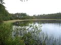
Lake Frösjön

Perhaps a well


Achievements
Llavids earned the Land geohash achievement
|
Llavids earned the Drag-along achievement
|
Llavids earned the Picnic achievement
|
Llavids achieved level 1 of the Minesweeper Geohash achievement
|