Difference between revisions of "2010-09-26 50 8"
imported>Mampfred (Created page with '{{subst:Expedition |lat = 50 |lon = 8 |date = 2010-09-26 }}') |
imported>FippeBot m (Location) |
||
| (9 intermediate revisions by 2 users not shown) | |||
| Line 1: | Line 1: | ||
| − | |||
| − | |||
| − | |||
| − | |||
| − | |||
| − | |||
| − | |||
| − | |||
| − | |||
| − | |||
{{meetup graticule | {{meetup graticule | ||
| lat=50 | | lat=50 | ||
| Line 15: | Line 5: | ||
}} | }} | ||
| − | |||
| − | |||
== Location == | == Location == | ||
| − | + | The location is in the middle of the nature park Hoch-Taunus, i.e. in the middle of a forest close to the Feldberg and is as such a very popular area for sunday walks and hikes. It's incidentally very close to a hiking route called the "Zacken-Beilsteir-Steig" (see below). | |
== Participants == | == Participants == | ||
| − | + | *[[User:Mampfred|Mampfred]] | |
| + | *[[User:LadyBB|LadyBB]] | ||
| − | == | + | == Expedition == |
| − | + | We started off by car and travelled about 10km in the general direction of the hash. When we were about 1 km away, we spotted a small parking lot and took it. | |
| − | + | We studied a sign announcing some hiking trails and decided that the "Zacken-Beilsteir-Steig" would take us pretty close to the hash and we wouldn't have to walk through "raw forrest" for ages. So we took the route that we thought would announce that trail and went off. | |
| − | + | ||
| + | After following the trail for a while, we noticed that there's something wrong as we veered off further and further from the direction we wanted to get to - so we left the trail and took the direct route instead. | ||
| + | |||
| + | We eventually reached the hash by circling it a couple of times (Worst. GPS. Ever.) and managed to took a photo of the GPS with the coordinates being as close as possible. As we had to use a nokia mobile phone with Route 66 on it as our GPS, the location jumped every couple of seconds so although we were sure to be at the right location we couldn't get it to be on the display :( | ||
| − | + | We then decided to go back a different route and started off in the direction of a cell tower we could see through the trees. Next to the tower we found a nice new trail that we started to follow in the general direction back to our car. Little did we know that it was the ... you guessed it "Zacken-Beilsteir-Steig" - apparently we were too stupid to follow the right trail before and instead started down the "Weilsbergrundweg" ;) | |
| − | |||
== Photos == | == Photos == | ||
| Line 37: | Line 28: | ||
--> | --> | ||
<gallery perrow="5"> | <gallery perrow="5"> | ||
| + | Image:2010-09-26 50 8 Trail sign.jpg | This should be easy, just follow the trail. | ||
| + | Image:2010-09-26 50 8 Big trail.jpg | Big trail ... | ||
| + | Image:2010-09-26_50_8_Little_trail.jpg | ... became little trail ... | ||
| + | Image:2010-09-26 50 8 No trail.jpg | ... became no trail. Where the hell are we? | ||
| + | Image:2010-09-26 50 8 Coordinates.jpg | Right. Here we are :) | ||
| + | Image:2010-09-26 50 8 Cell tower.jpg | Impressive! | ||
| + | Image:2010-09-26 50 8 Bianca.jpg | Right, LadyBB was there too ;) | ||
</gallery> | </gallery> | ||
== Achievements == | == Achievements == | ||
{{#vardefine:ribbonwidth|800px}} | {{#vardefine:ribbonwidth|800px}} | ||
| − | + | {{Land geohash | |
| − | + | | latitude = 50 | |
| − | + | | longitude = 8 | |
| − | + | | date = 2010-09-26 | |
| − | + | | name = Mampfred and LadyBB | |
| − | + | | image = 2010-09-24 50 11 Coordinates.JPG | |
| − | + | }} | |
| − | + | {{drag-along | |
| − | + | | latitude=50 | |
| − | + | | longitude=8 | |
| − | -- | + | | date=2010-09-26 |
| − | + | | name=Mampfred | |
| − | + | | partner=LadyBB (at the time known as Bianca ;) | |
| + | | image=2010-09-26 50 8 Bianca.jpg | ||
| + | }} | ||
[[Category:Expeditions]] | [[Category:Expeditions]] | ||
| − | |||
[[Category:Expeditions with photos]] | [[Category:Expeditions with photos]] | ||
| − | |||
| − | |||
| − | |||
| − | |||
| − | |||
[[Category:Coordinates reached]] | [[Category:Coordinates reached]] | ||
| − | + | {{location|DE|HE|HG}} | |
| − | |||
| − | |||
| − | |||
| − | |||
| − | |||
| − | |||
| − | |||
| − | |||
| − | |||
Latest revision as of 03:53, 9 August 2019
| Sun 26 Sep 2010 in 50,8: 50.2387915, 8.4192035 geohashing.info google osm bing/os kml crox |
Location
The location is in the middle of the nature park Hoch-Taunus, i.e. in the middle of a forest close to the Feldberg and is as such a very popular area for sunday walks and hikes. It's incidentally very close to a hiking route called the "Zacken-Beilsteir-Steig" (see below).
Participants
Expedition
We started off by car and travelled about 10km in the general direction of the hash. When we were about 1 km away, we spotted a small parking lot and took it.
We studied a sign announcing some hiking trails and decided that the "Zacken-Beilsteir-Steig" would take us pretty close to the hash and we wouldn't have to walk through "raw forrest" for ages. So we took the route that we thought would announce that trail and went off.
After following the trail for a while, we noticed that there's something wrong as we veered off further and further from the direction we wanted to get to - so we left the trail and took the direct route instead.
We eventually reached the hash by circling it a couple of times (Worst. GPS. Ever.) and managed to took a photo of the GPS with the coordinates being as close as possible. As we had to use a nokia mobile phone with Route 66 on it as our GPS, the location jumped every couple of seconds so although we were sure to be at the right location we couldn't get it to be on the display :(
We then decided to go back a different route and started off in the direction of a cell tower we could see through the trees. Next to the tower we found a nice new trail that we started to follow in the general direction back to our car. Little did we know that it was the ... you guessed it "Zacken-Beilsteir-Steig" - apparently we were too stupid to follow the right trail before and instead started down the "Weilsbergrundweg" ;)
Photos
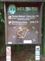
This should be easy, just follow the trail.
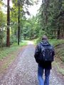
Big trail ...
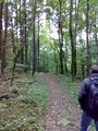
... became little trail ...
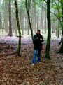
... became no trail. Where the hell are we?
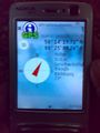
Right. Here we are :)
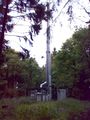
Impressive!
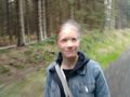
Right, LadyBB was there too ;)


Achievements
Mampfred and LadyBB earned the Land geohash achievement
|
Mampfred earned the Drag-along achievement
|