Difference between revisions of "2010-10-13 -36 174"
From Geohashing
imported>Greenslime m |
imported>Greenslime m (→Photos) |
||
| Line 22: | Line 22: | ||
== Photos == | == Photos == | ||
| − | |||
| − | |||
| − | |||
<gallery perrow="5"> | <gallery perrow="5"> | ||
| + | File:2010-10-13 -36 174 GMap.JPG|The hash map, hope i don't 'accidentally' lose my frisbee in the trees ;) | ||
</gallery> | </gallery> | ||
Revision as of 18:40, 12 October 2010
| Wed 13 Oct 2010 in -36,174: -36.8075388, 174.7564252 geohashing.info google osm bing/os kml crox |
Location
A backyard, right next to a park, right next to the Auckland Harbour Bridge
Participants
Plans
On first looking, i thought this had landed on the motorway, thus i would have passed through it on my commute this morning. Not quite, its in someones bushy back yard right next to a park. Im going to make more of an effort to get to the actual coordinates, i might try the frisbee approach. After work today, its all on!!
Expedition
Tracklog
Photos
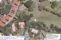
The hash map, hope i don't 'accidentally' lose my frisbee in the trees ;)

Achievements