Difference between revisions of "2010-10-20 48 11"
From Geohashing
imported>Sockenfresser (→Achievements) |
imported>FippeBot m (Location) |
||
| (One intermediate revision by one other user not shown) | |||
| Line 1: | Line 1: | ||
| − | |||
| − | |||
| − | |||
| − | |||
| − | |||
| − | |||
| − | |||
| − | |||
| − | |||
{{meetup graticule | {{meetup graticule | ||
| lat=48 | | lat=48 | ||
| Line 13: | Line 4: | ||
| date=2010-10-20 | | date=2010-10-20 | ||
}} | }} | ||
| − | |||
| − | |||
__NOTOC__ | __NOTOC__ | ||
== Location == | == Location == | ||
| Line 29: | Line 18: | ||
== Photos == | == Photos == | ||
| − | |||
| − | |||
| − | |||
<gallery perrow="5"> | <gallery perrow="5"> | ||
File:Geohash Dietersheim 2010 10 20 48 11.jpg|Weatherproof | File:Geohash Dietersheim 2010 10 20 48 11.jpg|Weatherproof | ||
| Line 38: | Line 24: | ||
== Achievements == | == Achievements == | ||
{{#vardefine:ribbonwidth|800px}} | {{#vardefine:ribbonwidth|800px}} | ||
| − | |||
{{land geohash | {{land geohash | ||
| − | |||
| latitude = 48 | | latitude = 48 | ||
| longitude = 11 | | longitude = 11 | ||
| Line 46: | Line 30: | ||
| name = sockenfresser | | name = sockenfresser | ||
| image = Geohash Dietersheim 2010 10 20 48 11.jpg | | image = Geohash Dietersheim 2010 10 20 48 11.jpg | ||
| − | |||
}} | }} | ||
{{Bicycle geohash | {{Bicycle geohash | ||
| − | |||
| latitude = 48 | | latitude = 48 | ||
| longitude = 11 | | longitude = 11 | ||
| Line 56: | Line 38: | ||
| image = Geohash Dietersheim 2010 10 20 48 11.jpg | | image = Geohash Dietersheim 2010 10 20 48 11.jpg | ||
| distance = 10 km | | distance = 10 km | ||
| − | |||
}} | }} | ||
{{Drowned rat geohash | {{Drowned rat geohash | ||
| − | |||
| latitude = 48 | | latitude = 48 | ||
| longitude = 11 | | longitude = 11 | ||
| Line 66: | Line 46: | ||
| image = Geohash Dietersheim 2010 10 20 48 11.jpg | | image = Geohash Dietersheim 2010 10 20 48 11.jpg | ||
| reason = terrible rain | | reason = terrible rain | ||
| − | |||
}} | }} | ||
| − | |||
| − | |||
| − | |||
| − | |||
| − | |||
| − | |||
| − | |||
| − | |||
| − | |||
| − | |||
| − | |||
[[Category:Expeditions]] | [[Category:Expeditions]] | ||
| − | |||
[[Category:Expeditions with photos]] | [[Category:Expeditions with photos]] | ||
| − | |||
| − | |||
| − | |||
| − | |||
| − | |||
[[Category:Coordinates reached]] | [[Category:Coordinates reached]] | ||
| − | + | {{location|DE|BY|FS}} | |
| − | |||
| − | |||
| − | |||
| − | |||
| − | |||
| − | |||
| − | |||
| − | |||
| − | |||
Latest revision as of 04:17, 9 August 2019
| Wed 20 Oct 2010 in 48,11: 48.2776468, 11.6759830 geohashing.info google osm bing/os kml crox |
Location
On a really muddy field near Dietersheim in the north-east of Munich.
Participants
Plans
No plan at all. Just saw that the hash is near and tried to get there in the evening.
Expedition
It's only 6 km from where I live but it was hard to get there, because I decided to get there by bike and the weather was terrible. 5°C and heavy rain.
Photos
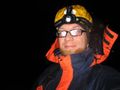
Weatherproof

Achievements
sockenfresser earned the Land geohash achievement
|
sockenfresser earned the Bicycle geohash achievement
|
sockenfresser earned the Drowned Rat Geohash Achievement
|