Difference between revisions of "2010-12-13 55 13"
imported>Fasanen (Created page with '{{subst:Expedition |lat = 55 |lon = 13 |date = 2010-12-13 }}') |
imported>FippeBot m (Location) |
||
| (3 intermediate revisions by one other user not shown) | |||
| Line 1: | Line 1: | ||
| − | |||
| − | |||
| − | |||
| − | |||
| − | |||
| − | |||
| − | |||
| − | |||
| − | |||
| − | |||
{{meetup graticule | {{meetup graticule | ||
| lat=55 | | lat=55 | ||
| Line 15: | Line 5: | ||
}} | }} | ||
| − | |||
__NOTOC__ | __NOTOC__ | ||
== Location == | == Location == | ||
| − | + | Derelict lot in Sulap, [[wikipedia:Skåne|Skåne]], [[wikipedia:Sweden|Sweden]]. | |
== Participants == | == Participants == | ||
| − | + | * [[User:Fasanen|Fasanen]] & Ms.C | |
| − | |||
| − | |||
| − | |||
== Expedition == | == Expedition == | ||
| − | + | We made a small detour and quick stop at this geohash on our way to Lund. By looking at aerial photographs, I suspected the place to be some sort of derelict lot and I was right. We stopped the car with 23 meters left to the location and stepped into a former garden which now was mainly used for storing a huge pile of twigs and branches. The ground was covered with a few centimeters of snow and ice but some building structures were still visible although most of it was thoroughly leveled with ground. | |
| − | + | Cold northerly winds made this a brief visit and after taking some photographs of the place and leaving the active geohasher leaflet as marker, we continued attending our less important business and headed for Lund. | |
| − | |||
== Photos == | == Photos == | ||
| − | < | + | <gallery perrow="3"> |
| − | Image: | + | Image:201012135513 01.JPG | 25 centimeters from target. |
| − | - | + | Image:201012135513 02.JPG | An old well... |
| − | + | Image:201012135513 03.JPG | ...and a basement. | |
| + | Image:201012135513 04.JPG | The rag; a hashing marker left by someone clairvoyant? | ||
| + | Image:201012135513 05.JPG | Yet another sub-zero hash. Not much of an achievement these days. | ||
</gallery> | </gallery> | ||
== Achievements == | == Achievements == | ||
{{#vardefine:ribbonwidth|800px}} | {{#vardefine:ribbonwidth|800px}} | ||
| − | + | {{land geohash | latitude=55 | longitude=13 | date=2010-12-13 | name=Fasanen}} | |
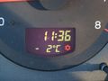
| + | {{Frozen Geohash | latitude = 55 | longitude = 13 | date = 2010-12-13 | name = Fasanen | temperature = -2°C }} | ||
| + | {{consecutive geohash | count = 2 | latitude = 55 | longitude = 13| date = 2010-12-12 | name = Fasanen }} | ||
| − | |||
| − | |||
| − | |||
| − | |||
| − | |||
| − | |||
| − | |||
| − | |||
| − | |||
| − | |||
| − | |||
[[Category:Expeditions]] | [[Category:Expeditions]] | ||
| − | |||
[[Category:Expeditions with photos]] | [[Category:Expeditions with photos]] | ||
| − | |||
| − | |||
| − | |||
| − | |||
| − | |||
[[Category:Coordinates reached]] | [[Category:Coordinates reached]] | ||
| − | + | {{location|SE|M}} | |
| − | |||
| − | |||
| − | |||
| − | |||
| − | |||
| − | |||
| − | |||
| − | |||
| − | |||
Latest revision as of 04:55, 9 August 2019
| Mon 13 Dec 2010 in 55,13: 55.7088719, 13.2980112 geohashing.info google osm bing/os kml crox |
Location
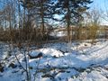
Derelict lot in Sulap, Skåne, Sweden.
Participants
- Fasanen & Ms.C
Expedition
We made a small detour and quick stop at this geohash on our way to Lund. By looking at aerial photographs, I suspected the place to be some sort of derelict lot and I was right. We stopped the car with 23 meters left to the location and stepped into a former garden which now was mainly used for storing a huge pile of twigs and branches. The ground was covered with a few centimeters of snow and ice but some building structures were still visible although most of it was thoroughly leveled with ground.
Cold northerly winds made this a brief visit and after taking some photographs of the place and leaving the active geohasher leaflet as marker, we continued attending our less important business and headed for Lund.
Photos
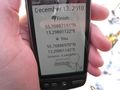
25 centimeters from target.
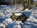
An old well...
...and a basement.
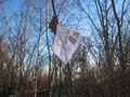
The rag; a hashing marker left by someone clairvoyant?
Yet another sub-zero hash. Not much of an achievement these days.


Achievements
Fasanen earned the Land geohash achievement
|
Fasanen earned the Frozen Geohash Achievement
|
Fasanen earned the Consecutive geohash achievement
|