Difference between revisions of "2010-12-15 55 13"
imported>Fasanen (Created page with '{{subst:Expedition |lat = 55 |lon = 13 |date = 2010-12-15 }}') |
imported>FippeBot m (Location) |
||
| (2 intermediate revisions by one other user not shown) | |||
| Line 1: | Line 1: | ||
| − | |||
| − | |||
| − | |||
| − | |||
| − | |||
| − | |||
| − | |||
| − | |||
| − | |||
| − | |||
{{meetup graticule | {{meetup graticule | ||
| lat=55 | | lat=55 | ||
| Line 18: | Line 8: | ||
__NOTOC__ | __NOTOC__ | ||
== Location == | == Location == | ||
| − | + | Forest in Häckeberga, [[wikipedia:Skåne|Skåne]], [[wikipedia:Sweden|Sweden]] | |
== Participants == | == Participants == | ||
| − | + | * [[User:Fasanen|Fasanen]] | |
== Plans == | == Plans == | ||
| − | + | Go to the hash in the evening and find a geocache or two afterwards. | |
== Expedition == | == Expedition == | ||
| − | + | The Häckeberga forests are always nice to visit so this geohash was tempting. I expected the exact geohash location to be in fairly dense fir forest with some nice beech wood surrounding it but when I got there around 19.00, it became apparent that it all had turned into a clear-felled area. | |
| − | + | Hordes of roe deer roamed in the darkness and that felt a bit spooky. The clear-cut was quite easy to walk. I followed the tracks of big forest machines for less than 200 meters. The ground was covered with not too deep, packed snow. The most exciting item at the hashpoint was a fallen spruce. After photographing I walked back in my own track. | |
| − | + | ||
| + | Now it was time for some geocaching. I drove to the vicinity of the chosen cache without navigation aid and turned on the geocaching application in the phone. Not much happened. Cell coverage was bad and I eventually gave up further attempts and headed back home. | ||
== Photos == | == Photos == | ||
| − | < | + | <gallery perrow="3"> |
| − | Image: | + | Image:201012155513 01.JPG | Coordinates reached. |
| − | - | + | Image:201012155513 02.JPG | Dark and lonely |
| − | + | Image:201012155513 03.JPG | Look, a geohash! | |
| + | Image:201012155513 04.JPG | -5. Good. No mosquitos today. | ||
| + | Image:201012155513 05.JPG | Evidence of recent serious lumbering | ||
</gallery> | </gallery> | ||
== Achievements == | == Achievements == | ||
{{#vardefine:ribbonwidth|800px}} | {{#vardefine:ribbonwidth|800px}} | ||
| − | + | {{land geohash | latitude=55 | longitude=13 | date=2010-12-15 | name=Fasanen}} | |
| + | {{Frozen Geohash | latitude = 55 | longitude = 13 | date = 2010-12-15 | name = Fasanen | temperature = -5°C }} | ||
| − | |||
| − | |||
| − | |||
| − | |||
| − | |||
| − | |||
| − | |||
| − | |||
| − | |||
| − | |||
| − | |||
[[Category:Expeditions]] | [[Category:Expeditions]] | ||
| − | |||
[[Category:Expeditions with photos]] | [[Category:Expeditions with photos]] | ||
| − | |||
| − | |||
| − | |||
| − | |||
| − | |||
[[Category:Coordinates reached]] | [[Category:Coordinates reached]] | ||
| − | + | [[Category:Sweden]] | |
| − | + | {{location|SE|M}} | |
| − | |||
| − | [[Category: | ||
| − | |||
| − | |||
| − | |||
| − | |||
| − | |||
| − | |||
Latest revision as of 04:56, 9 August 2019
| Wed 15 Dec 2010 in 55,13: 55.5809127, 13.4620689 geohashing.info google osm bing/os kml crox |
Location
Forest in Häckeberga, Skåne, Sweden
Participants
Plans
Go to the hash in the evening and find a geocache or two afterwards.
Expedition
The Häckeberga forests are always nice to visit so this geohash was tempting. I expected the exact geohash location to be in fairly dense fir forest with some nice beech wood surrounding it but when I got there around 19.00, it became apparent that it all had turned into a clear-felled area.
Hordes of roe deer roamed in the darkness and that felt a bit spooky. The clear-cut was quite easy to walk. I followed the tracks of big forest machines for less than 200 meters. The ground was covered with not too deep, packed snow. The most exciting item at the hashpoint was a fallen spruce. After photographing I walked back in my own track.
Now it was time for some geocaching. I drove to the vicinity of the chosen cache without navigation aid and turned on the geocaching application in the phone. Not much happened. Cell coverage was bad and I eventually gave up further attempts and headed back home.
Photos
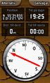
Coordinates reached.
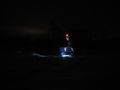
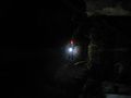
Dark and lonely
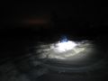
Look, a geohash!
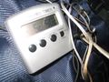
-5. Good. No mosquitos today.
Evidence of recent serious lumbering


Achievements
Fasanen earned the Land geohash achievement
|
Fasanen earned the Frozen Geohash Achievement
|