Difference between revisions of "2010-12-29 55 13"
imported>Fasanen (Created page with "{{subst:Expedition |lat = 55 |lon = 13 |date = 2010-12-29 }}") |
imported>FippeBot m (Location) |
||
| (2 intermediate revisions by one other user not shown) | |||
| Line 1: | Line 1: | ||
| − | |||
| − | |||
| − | |||
| − | |||
| − | |||
| − | |||
| − | |||
| − | |||
| − | |||
| − | |||
{{meetup graticule | {{meetup graticule | ||
| lat=55 | | lat=55 | ||
| Line 15: | Line 5: | ||
}} | }} | ||
| − | |||
__NOTOC__ | __NOTOC__ | ||
== Location == | == Location == | ||
| − | + | In a field just a stone's throw north of [[wikipedia:Sege_River|Sege River]] in Krågeholm, [[wikipedia:Skåne|Skåne]], [[wikipedia:Sweden|Sweden]]. | |
== Participants == | == Participants == | ||
| − | + | * [[User:Fasanen|Fasanen]] | |
== Plans == | == Plans == | ||
| − | + | Bring skis, reach hash and have fun. | |
== Expedition == | == Expedition == | ||
| − | + | Too bad I could not get away earlier but when I parked the car beside road just south of Krågeholm, the last faint rays of sunshine were shimmering in the western horizon. Minutes later it was going to be pitch dark. I took my skis out of the boot and turned on the GPS; 530 meters left to the geohash. | |
| + | |||
| + | I found a path in the snow where someone had been walking one or more dogs several times. Dog poop was lying along the path like pebbles in the story about Hansel and Gretel, but under the present circumstances (-14° C) they were deep frozen. The path was conveniently following Sege River and ended just about 100 meters from the hash. | ||
| + | |||
| + | I got to the hashpoint and and took some photographs. When the camera battery died, I was not inclined to change it. I almost got my right fingers frostbitten. | ||
| − | + | Back at the car I wondered if this had been my last geohash this year. | |
| − | |||
== Photos == | == Photos == | ||
| − | < | + | <gallery perrow="4"> |
| − | Image: | + | Image:201012295513 01.JPG | Proof. |
| − | - | + | Image:201012295513 02.JPG | Me, sparingly lightened by stars and GPS screen. |
| − | + | Image:201012295513 03.JPG | My coldest geohash so far. -14°C. | |
| + | Image:201012295513 04.JPG | Sunset, last stage. | ||
</gallery> | </gallery> | ||
== Achievements == | == Achievements == | ||
{{#vardefine:ribbonwidth|800px}} | {{#vardefine:ribbonwidth|800px}} | ||
| − | + | {{land geohash | latitude=55 | longitude=13 | date=2010-12-29 | name=Fasanen}} | |
| + | {{Frozen Geohash | latitude = 55 | longitude = 13 | date = 2010-12-29 | name = Fasanen | temperature = -14°C }} | ||
| − | |||
| − | |||
| − | |||
| − | |||
| − | |||
| − | |||
| − | |||
| − | |||
| − | |||
| − | |||
| − | |||
[[Category:Expeditions]] | [[Category:Expeditions]] | ||
| − | |||
[[Category:Expeditions with photos]] | [[Category:Expeditions with photos]] | ||
| − | |||
| − | |||
| − | |||
| − | |||
| − | |||
[[Category:Coordinates reached]] | [[Category:Coordinates reached]] | ||
| − | + | [[Category:Sweden]] | |
| − | + | {{location|SE|M}} | |
| − | |||
| − | [[Category: | ||
| − | |||
| − | |||
| − | |||
| − | |||
| − | |||
| − | |||
Latest revision as of 05:05, 9 August 2019
| Wed 29 Dec 2010 in 55,13: 55.4977575, 13.2038733 geohashing.info google osm bing/os kml crox |
Location
In a field just a stone's throw north of Sege River in Krågeholm, Skåne, Sweden.
Participants
Plans
Bring skis, reach hash and have fun.
Expedition
Too bad I could not get away earlier but when I parked the car beside road just south of Krågeholm, the last faint rays of sunshine were shimmering in the western horizon. Minutes later it was going to be pitch dark. I took my skis out of the boot and turned on the GPS; 530 meters left to the geohash.
I found a path in the snow where someone had been walking one or more dogs several times. Dog poop was lying along the path like pebbles in the story about Hansel and Gretel, but under the present circumstances (-14° C) they were deep frozen. The path was conveniently following Sege River and ended just about 100 meters from the hash.
I got to the hashpoint and and took some photographs. When the camera battery died, I was not inclined to change it. I almost got my right fingers frostbitten.
Back at the car I wondered if this had been my last geohash this year.
Photos
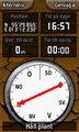
Proof.
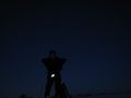
Me, sparingly lightened by stars and GPS screen.
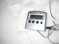
My coldest geohash so far. -14°C.
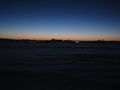
Sunset, last stage.


Achievements
Fasanen earned the Land geohash achievement
|
