Difference between revisions of "2011-01-08 41 -91"
imported>Phogan (Created page with "{{subst:Expedition |lat = latitude of graticule |lon = longitude of graticule |date = date of expedition, in YYYY-MM-DD format }}") |
imported>FippeBot m (Location) |
||
| (7 intermediate revisions by 2 users not shown) | |||
| Line 1: | Line 1: | ||
| − | |||
<!-- If you did not specify these parameters in the template, please substitute appropriate values for IMAGE, LAT, LON, and DATE (YYYY-MM-DD format) | <!-- If you did not specify these parameters in the template, please substitute appropriate values for IMAGE, LAT, LON, and DATE (YYYY-MM-DD format) | ||
| Line 10: | Line 9: | ||
--> | --> | ||
{{meetup graticule | {{meetup graticule | ||
| − | | lat= | + | | lat=41 |
| − | | lon= | + | | lon=-91 |
| − | | date= | + | | date=2011-01-08 |
}} | }} | ||
| − | + | ||
__NOTOC__ | __NOTOC__ | ||
== Location == | == Location == | ||
| − | + | In a farm field off a gravel road outside Washington, Iowa. | |
== Participants == | == Participants == | ||
| − | + | [[User:Phogan|phogan]] | |
== Plans == | == Plans == | ||
| − | + | To get to the dang place, as this was my very first experience geohashing | |
== Expedition == | == Expedition == | ||
| − | + | This was my very first experience geohashing. It went very smoothly, although I think it's a preview of what I'm going to expect from this graticule if I keep this habit up. | |
| + | |||
| + | My Droid sent me south from Iowa City on a well-paved four lane highway, however about ten miles away it sent me off the main road and I soon found I was on gravel roads. My car is a simple Hyundai Elantra, so I was a little nervous as to how it would handle the backroads, but it performed like a champ. | ||
| − | + | When I got as close as I could in my car, I was surrounded on all sides by fields that probably in better | |
| − | + | weather are filled with corn. A few farm houses dotted the horizon, but otherwise, I was the only soul for miles around. | |
| + | |||
| + | The hash location was close to the road, but not close enough, I was still 300 meters off, and the only way to get | ||
| + | close was to get on private farmland. This is where I demurred. | ||
| + | |||
| + | Granted there weren't people for miles around, | ||
| + | but I know about as much about farming as I did about geohashing three weeks ago, and wasn't sure if by | ||
| + | walking onto the farmland I might somehow damage it for future crops (if any experienced hashers | ||
| + | could advice me on this, I would greatly appreciate it). | ||
| + | |||
| + | I took a picture that probably has the | ||
| + | hash location on the horizon, and that's it. I went into the nearby town of Washington and found a | ||
| + | coffee shop, which is where I'm typing this. | ||
== Photos == | == Photos == | ||
| − | |||
| − | |||
| − | |||
<gallery perrow="5"> | <gallery perrow="5"> | ||
| + | Image:2011-01-08_41_-91.jpg | This is 300 meters out, so the hash location is probably somewhere on the horizon | ||
| + | |||
</gallery> | </gallery> | ||
| Line 42: | Line 54: | ||
{{#vardefine:ribbonwidth|800px}} | {{#vardefine:ribbonwidth|800px}} | ||
<!-- Add any achievement ribbons you earned below, or remove this section --> | <!-- Add any achievement ribbons you earned below, or remove this section --> | ||
| + | |||
| + | * No Trespassing | ||
| − | |||
| − | |||
| − | |||
| − | |||
| − | |||
| − | |||
| − | |||
| − | |||
[[Category:Expeditions]] | [[Category:Expeditions]] | ||
| − | |||
[[Category:Expeditions with photos]] | [[Category:Expeditions with photos]] | ||
| − | |||
| − | |||
| − | |||
| − | |||
| − | |||
| − | |||
| − | |||
| − | |||
[[Category:Coordinates not reached]] | [[Category:Coordinates not reached]] | ||
| − | + | [[Category:Not reached - No public access]] | |
| − | + | {{location|US|IA|WS}} | |
| − | [[Category:Not reached - No public access]] | ||
| − | |||
| − | |||
| − | |||
Latest revision as of 03:43, 6 August 2019
| Sat 8 Jan 2011 in 41,-91: 41.2864810, -91.6481846 geohashing.info google osm bing/os kml crox |
Location
In a farm field off a gravel road outside Washington, Iowa.
Participants
Plans
To get to the dang place, as this was my very first experience geohashing
Expedition
This was my very first experience geohashing. It went very smoothly, although I think it's a preview of what I'm going to expect from this graticule if I keep this habit up.
My Droid sent me south from Iowa City on a well-paved four lane highway, however about ten miles away it sent me off the main road and I soon found I was on gravel roads. My car is a simple Hyundai Elantra, so I was a little nervous as to how it would handle the backroads, but it performed like a champ.
When I got as close as I could in my car, I was surrounded on all sides by fields that probably in better weather are filled with corn. A few farm houses dotted the horizon, but otherwise, I was the only soul for miles around.
The hash location was close to the road, but not close enough, I was still 300 meters off, and the only way to get close was to get on private farmland. This is where I demurred.
Granted there weren't people for miles around, but I know about as much about farming as I did about geohashing three weeks ago, and wasn't sure if by walking onto the farmland I might somehow damage it for future crops (if any experienced hashers could advice me on this, I would greatly appreciate it).
I took a picture that probably has the hash location on the horizon, and that's it. I went into the nearby town of Washington and found a coffee shop, which is where I'm typing this.
Photos
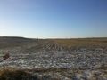
This is 300 meters out, so the hash location is probably somewhere on the horizon

Achievements
- No Trespassing