Difference between revisions of "2011-01-14 50 8"
From Geohashing
imported>QuarterCacher |
imported>Mampfred (→Photos) |
||
| Line 24: | Line 24: | ||
Image:2011-01-14_50_8_no_ chance.jpg | No chance for me to reach the hash point. | Image:2011-01-14_50_8_no_ chance.jpg | No chance for me to reach the hash point. | ||
</gallery> | </gallery> | ||
| − | |||
[[Category:Expeditions]] | [[Category:Expeditions]] | ||
[[Category:Coordinates not reached]] | [[Category:Coordinates not reached]] | ||
[[Category:Not reached - Mother Nature]] | [[Category:Not reached - Mother Nature]] | ||
Revision as of 20:23, 27 January 2011
| Fri 14 Jan 2011 in 50,8: 50.0981882, 8.5488458 geohashing.info google osm bing/os kml crox |
Location
In a parking lot on the shore of the river Main just at the edge about 1-2 meter from the water under normal conditions.
Participants
Expedition
I planned to go there after work, park my car, make some pictures and go home - easy hash. But due to severe flooding I couldn't make it. On my way there I saw that large areas were flooded, parks, playgrounds even quite far away from the river Main. After parking at the last dry bit of the road I was looking for a way to reach the hash point but about 150 meter ahead of it there was nothing but cold water. As the flood lastet for some more days I couldn't reach the hash point in time. :-(
Photos
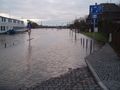
Road and footpath flooded.
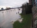
No chance for me to reach the hash point.

