Difference between revisions of "2011-01-28 46 4"
From Geohashing
imported>ClementB (→Achievements) |
imported>FippeBot m (Location) |
||
| (2 intermediate revisions by 2 users not shown) | |||
| Line 1: | Line 1: | ||
| − | |||
<!-- If you did not specify these parameters in the template, please substitute appropriate values for IMAGE, LAT, LON, and DATE (YYYY-MM-DD format) | <!-- If you did not specify these parameters in the template, please substitute appropriate values for IMAGE, LAT, LON, and DATE (YYYY-MM-DD format) | ||
| Line 15: | Line 14: | ||
}} | }} | ||
| − | + | ||
__NOTOC__ | __NOTOC__ | ||
== Location == | == Location == | ||
| − | + | ||
In the woods above Saint-Gengoux-Le-National | In the woods above Saint-Gengoux-Le-National | ||
| Line 26: | Line 25: | ||
== Plans == | == Plans == | ||
| − | + | ||
Leaving from Lugny where I'm on vacation, I was planning to eat in Cluny, and then proceed by car to the point. | Leaving from Lugny where I'm on vacation, I was planning to eat in Cluny, and then proceed by car to the point. | ||
== Expedition == | == Expedition == | ||
| − | + | ||
| − | I left Lugny at 12:30pm to Cluny, where I eated in a Brasserie (Assiette lyonnaise and Fondant au chocolat), and then took off to Saint-Gengoux. I left my car on a road and walked to the point. It was chilly, but the weather was nice, | + | I left Lugny at 12:30pm to Cluny, where I eated in a Brasserie (Assiette lyonnaise and Fondant au chocolat), and then took off to Saint-Gengoux. |
| + | I left my car on a road and walked to the point. It was chilly, but the weather was nice, | ||
| + | and the landscape beautiful. | ||
| + | |||
| + | My phone is not very accurate so it took me quite a while to find the spot. | ||
A nice afternoon :) | A nice afternoon :) | ||
| − | == | + | == Photos == |
| − | |||
| − | |||
| − | |||
| − | |||
| − | |||
<gallery perrow="5"> | <gallery perrow="5"> | ||
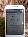
| + | Image:2011-01-28 46 4 Proof.JPG | Proof | ||
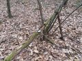
| + | Image:2011-01-28 46 4 Point.JPG | The area | ||
| + | Image:2011-01-28 46 4 Grin.JPG | Myself | ||
</gallery> | </gallery> | ||
| Line 49: | Line 50: | ||
<!-- Add any achievement ribbons you earned below, or remove this section --> | <!-- Add any achievement ribbons you earned below, or remove this section --> | ||
| + | * Land Geohash | ||
[[Category:Expeditions]] | [[Category:Expeditions]] | ||
| − | + | ||
[[Category:Expeditions with photos]] | [[Category:Expeditions with photos]] | ||
[[Category:Coordinates reached]] | [[Category:Coordinates reached]] | ||
| + | {{location|FR|71}} | ||
Latest revision as of 05:23, 9 August 2019
| Fri 28 Jan 2011 in 46,4: 46.6289141, 4.6708291 geohashing.info google osm bing/os kml crox |
Location
In the woods above Saint-Gengoux-Le-National
Participants
Plans
Leaving from Lugny where I'm on vacation, I was planning to eat in Cluny, and then proceed by car to the point.
Expedition
I left Lugny at 12:30pm to Cluny, where I eated in a Brasserie (Assiette lyonnaise and Fondant au chocolat), and then took off to Saint-Gengoux. I left my car on a road and walked to the point. It was chilly, but the weather was nice, and the landscape beautiful.
My phone is not very accurate so it took me quite a while to find the spot.
A nice afternoon :)
Photos
Proof
The area

Myself


Achievements
- Land Geohash