Difference between revisions of "2011-02-02 51 10"
From Geohashing
imported>Mampfred |
imported>Mampfred |
||
| Line 7: | Line 7: | ||
__NOTOC__ | __NOTOC__ | ||
== Location == | == Location == | ||
| − | + | Next to a paved road in the middle of some fields near Bad Tennstedt. | |
== Participants == | == Participants == | ||
| Line 14: | Line 14: | ||
== Plans == | == Plans == | ||
| − | + | Go there after work, should be a quick drive there-get out of the car-drive back type of hash. | |
== Expedition == | == Expedition == | ||
| − | + | It did exactly what it said on the tin ... aeh, in the Plans section. Frozen field so we didn't even get our shoes dirty. On the way back we passed the coordinates for the [http://coord.info/GC1TCVP GC1TCVP] geocache but failed miserably possibly due to darkness and/or too much water under the bridge - literally. | |
== Tracklog == | == Tracklog == | ||
| − | + | See [http://www.everytrail.com/view_trip.php?trip_id=954080 here]. | |
== Photos == | == Photos == | ||
| − | |||
| − | |||
| − | |||
<gallery perrow="5"> | <gallery perrow="5"> | ||
| + | Image:2011-02-02_51_10_coordinates.jpg | Coordinates ... | ||
| + | Image:2011-02-02_51_10_reached.jpg | ... reached. | ||
| + | Image:2011-02-02_51_10_grin.jpg | Classic grins | ||
</gallery> | </gallery> | ||
== Achievements == | == Achievements == | ||
{{#vardefine:ribbonwidth|800px}} | {{#vardefine:ribbonwidth|800px}} | ||
| − | + | {{Land geohash | |
| + | | latitude = 51 | ||
| + | | longitude = 10 | ||
| + | | date = 2011-02-02 | ||
| + | | name = [[User:Mampfred|Mampfred]] and [[User:Rincewind|Rincewind]] | ||
| + | }} | ||
| − | |||
| − | |||
| − | |||
[[Category:Expeditions]] | [[Category:Expeditions]] | ||
| − | |||
[[Category:Expeditions with photos]] | [[Category:Expeditions with photos]] | ||
| − | |||
| − | |||
| − | |||
| − | |||
| − | |||
[[Category:Coordinates reached]] | [[Category:Coordinates reached]] | ||
| − | |||
| − | |||
| − | |||
| − | |||
| − | |||
| − | |||
| − | |||
| − | |||
| − | |||
| − | |||
Revision as of 20:11, 2 February 2011
| Wed 2 Feb 2011 in 51,10: 51.1442511, 10.8620919 geohashing.info google osm bing/os kml crox |
Location
Next to a paved road in the middle of some fields near Bad Tennstedt.
Participants
Plans
Go there after work, should be a quick drive there-get out of the car-drive back type of hash.
Expedition
It did exactly what it said on the tin ... aeh, in the Plans section. Frozen field so we didn't even get our shoes dirty. On the way back we passed the coordinates for the GC1TCVP geocache but failed miserably possibly due to darkness and/or too much water under the bridge - literally.
Tracklog
See here.
Photos
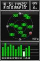
Coordinates ...
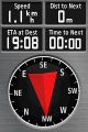
... reached.
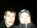
Classic grins


Achievements
Mampfred and Rincewind earned the Land geohash achievement
|