Difference between revisions of "2011-02-04 53 -1"
imported>MykaDragonBlue (→Plans: bus numbers) |
imported>FippeBot m (Location) |
||
| (2 intermediate revisions by one other user not shown) | |||
| Line 15: | Line 15: | ||
== Expedition == | == Expedition == | ||
| − | + | I had contemplated a final use of the bike before i figure out what to do with it... but today is significantly windy, and that seemed like a bad idea. instead, i took a quick bus trip out to the has area, missing my stop of course. | |
| + | |||
| + | On the way I played with my shiny new GPS, and marveled at the fact that it had a maps on it. | ||
| + | |||
| + | I wandered up to the hash hill, and was amused by the fact that this little hill, covered in the same dreary houses that are everywhere here, is named Green Hill Mount. | ||
| + | |||
| + | I made the best of the GPS display to get a proof shot (i later found a better data field to show, but oh well), then wandered up the hash driveway and found the point. | ||
| + | |||
| + | Not wanting to potentially upset the homeowners too much, i then took a quick couple of photos from the street, and headed off. | ||
| + | |||
| + | One feature of the GPS I wanted to test was the routing, so on a different bus home, I turned it on, and was pleasantly surprised. (yes, I know many people are used to this sort of feature, but this is the first GPS I've owned which has maps (from OSM) and on road routing etc.) Incidentally, the bus didn't follow the route the GPS suggested... | ||
== Tracklog == | == Tracklog == | ||
| Line 21: | Line 31: | ||
== Photos == | == Photos == | ||
| − | |||
| − | |||
| − | |||
<gallery perrow="5"> | <gallery perrow="5"> | ||
| + | Image:2011-02-04 53 -1 mdb 001.jpg | no droid joy again | ||
| + | Image:2011-02-04 53 -1 mdb 002.jpg | proofs | ||
| + | Image:2011-02-04 53 -1 mdb 003.jpg | [[User:MykaDragonBlue/Hashscot|Possibly Fergus]] at the hash driveway | ||
| + | Image:2011-02-04 53 -1 mdb 004.jpg | happy english weather | ||
| + | Image:2011-02-04 53 -1 mdb 005.jpg | a green hill hash house | ||
| + | Image:2011-02-04 53 -1 mdb 006.jpg | peekaboo doors are interesting | ||
</gallery> | </gallery> | ||
| Line 32: | Line 45: | ||
| − | |||
| − | |||
| − | |||
| − | |||
[[Category:Expeditions]] | [[Category:Expeditions]] | ||
| − | + | [[Category:Expeditions with photos]] | |
| − | [[Category:Expeditions with photos]] | ||
| − | |||
| − | |||
| − | |||
| − | |||
| − | |||
[[Category:Coordinates reached]] | [[Category:Coordinates reached]] | ||
| − | + | {{location|GB|ENG|LDS}} | |
| − | |||
| − | |||
| − | |||
| − | |||
| − | |||
| − | |||
| − | |||
| − | |||
| − | |||
Latest revision as of 05:27, 9 August 2019
| Fri 4 Feb 2011 in 53,-1: 53.8029798, -1.6170145 geohashing.info google osm bing/os kml crox |
Location
about 5km out of leeds city center, on a driveway off Green Hill Drive, Bramley
Participants
- myka with possibly fergus
Plans
- myka will probably catch a bus (First Leeds/40/40A or First Bradford/72) out at some time during the day. It's a bit hard to pin down a time as yet, since I have a courier pickup to deal with, and i don't yet have the final time window available to me.
Expedition
I had contemplated a final use of the bike before i figure out what to do with it... but today is significantly windy, and that seemed like a bad idea. instead, i took a quick bus trip out to the has area, missing my stop of course.
On the way I played with my shiny new GPS, and marveled at the fact that it had a maps on it.
I wandered up to the hash hill, and was amused by the fact that this little hill, covered in the same dreary houses that are everywhere here, is named Green Hill Mount.
I made the best of the GPS display to get a proof shot (i later found a better data field to show, but oh well), then wandered up the hash driveway and found the point.
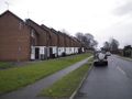
Not wanting to potentially upset the homeowners too much, i then took a quick couple of photos from the street, and headed off.
One feature of the GPS I wanted to test was the routing, so on a different bus home, I turned it on, and was pleasantly surprised. (yes, I know many people are used to this sort of feature, but this is the first GPS I've owned which has maps (from OSM) and on road routing etc.) Incidentally, the bus didn't follow the route the GPS suggested...
Tracklog
Photos
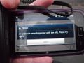
no droid joy again
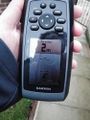
proofs
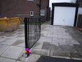
Possibly Fergus at the hash driveway
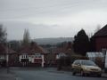
happy english weather
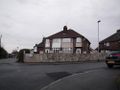
a green hill hash house
peekaboo doors are interesting


