Difference between revisions of "2011-02-21 52 5"
From Geohashing
imported>Antior |
imported>FippeBot m (Location) |
||
| (6 intermediate revisions by 2 users not shown) | |||
| Line 1: | Line 1: | ||
| − | + | [[Image:2011-02-21_52_5e.jpg|thumb|left]] | |
| − | |||
| − | |||
| − | |||
| − | |||
| − | |||
| − | |||
| − | |||
{{meetup graticule | {{meetup graticule | ||
| lat=52 | | lat=52 | ||
| Line 20: | Line 13: | ||
== Participants == | == Participants == | ||
| − | A friend of [[User: | + | A friend of [[User:CO2|CO2's]]. |
== Plans == | == Plans == | ||
| Line 26: | Line 19: | ||
== Expedition == | == Expedition == | ||
| − | + | ''(This report was written by CO2's friend)'' | |
| + | |||
| + | The hashpoint was near a bus stop I always pass, so easy enough to get to. I got off the bus at said bus stop and walked to the hash in the freezing cold. The hashpoint was two blocks away, right on a parking spot, with a car parked right on it. I took some pictures there and then returned to the warm bus and continued my way to class. | ||
== Photos == | == Photos == | ||
| − | |||
| − | |||
| − | |||
<gallery perrow="5"> | <gallery perrow="5"> | ||
| + | Image:2011-02-21_52_5a.jpg | Bus stop | ||
| + | Image:2011-02-21_52_5b.jpg | Hashpoint | ||
| + | Image:2011-02-21_52_5c.jpg | Street with the hashpoint | ||
| + | Image:2011-02-21_52_5d.jpg | Canal next to the street | ||
| + | Image:2011-02-21_52_5e.jpg | Typical bus in Utrecht | ||
</gallery> | </gallery> | ||
== Achievements == | == Achievements == | ||
{{#vardefine:ribbonwidth|800px}} | {{#vardefine:ribbonwidth|800px}} | ||
| − | |||
| + | {{land geohash | ||
| + | | latitude = 52 | ||
| + | | longitude = 5 | ||
| + | | date = 2011-02-21 | ||
| + | }} | ||
| − | + | {{No_batteries_geohash | |
| − | + | | latitude = 52 | |
| − | + | | longitude = 5 | |
| − | + | | date = 2011-02-21 | |
| − | + | }} | |
| − | |||
| − | |||
| + | Possibly also a Freezing Geohash, but this can't be proven. | ||
| − | |||
[[Category:Expeditions]] | [[Category:Expeditions]] | ||
| − | |||
[[Category:Expeditions with photos]] | [[Category:Expeditions with photos]] | ||
| − | |||
[[Category:Expedition without GPS]] | [[Category:Expedition without GPS]] | ||
| − | |||
| − | |||
| − | |||
[[Category:Coordinates reached]] | [[Category:Coordinates reached]] | ||
| − | + | {{location|NL|UT}} | |
| − | |||
| − | |||
| − | |||
| − | |||
| − | |||
| − | |||
| − | |||
| − | |||
| − | |||
Latest revision as of 05:37, 9 August 2019
| Mon 21 Feb 2011 in 52,5: 52.0777414, 5.1213441 geohashing.info google osm bing/os kml crox |
Location
In the center of Utrecht.
Participants
A friend of CO2's.
Plans
It's close to a bus stop. Just visit it and take a few pictures.
Expedition
(This report was written by CO2's friend)
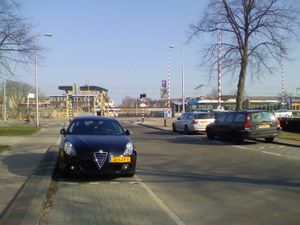
The hashpoint was near a bus stop I always pass, so easy enough to get to. I got off the bus at said bus stop and walked to the hash in the freezing cold. The hashpoint was two blocks away, right on a parking spot, with a car parked right on it. I took some pictures there and then returned to the warm bus and continued my way to class.
Photos
Achievements
This user earned the Land geohash achievement
|
This user earned the No Batteries Geohash Achievement
|
Possibly also a Freezing Geohash, but this can't be proven.


