Difference between revisions of "2011-03-12 45 -122"
imported>Jiml (More Details) |
imported>Jiml (Finish up report) |
||
| Line 1: | Line 1: | ||
| − | + | [[Image:{{{image|2011-03-12_45_-122-Area2.jpg}}}|thumb|left]] | |
| − | |||
| − | |||
| − | |||
| − | |||
| − | |||
| − | |||
| − | |||
{{meetup graticule | {{meetup graticule | ||
| lat=45 | | lat=45 | ||
| Line 45: | Line 38: | ||
door. No answer. | door. No answer. | ||
| − | I gave up and walked back to the car. Then I looked more closely at the field layout, and realized that maybe there was a different house to check with. I walked back to the main street from the cul-de-sac I was on and knocked on the door there. Still no answer. | + | I gave up and walked back to the car. Then I looked more closely at the field layout, |
| + | and realized that maybe there was a different house to check with. I walked back to | ||
| + | the main street from the cul-de-sac I was on and knocked on the door there. Still no answer. | ||
As I turned to leave, a young woman emerged from the back of the house saying I was knocking at | As I turned to leave, a young woman emerged from the back of the house saying I was knocking at | ||
| − | the door they didn't use. | + | the door they didn't use. I explained what I was on a scavenger hunt, and that I wanted to |
| + | their field. She said it belonged to the person who lived inside, and it was fine for me to | ||
| + | go in. | ||
| + | |||
| + | So, I returned to the car, and switched to my Muck Boots, which proved to be a wise choice. I | ||
| + | headed into what I thought was the field with a spring in my step, because I was going | ||
| + | to get to a hashpoint for once. But it soon became very muddy and then very wet. | ||
| + | Luckily, when one is wearing Muck Boots, one doesn't worry about such things. Soon I looked | ||
| + | to my left, and realized there was a second field. Which belonged to the house I had | ||
| + | first tried. I had a sinking feeling, and it wasn't from standing in a muddy field. | ||
| + | |||
| + | As I got to the end of the field, I looked at the GPS, hoping against hope. | ||
| + | It was still about a | ||
| + | hundred feet - back towards the street I had came from. The hashpoint really was in the | ||
| + | "inbetween" field. | ||
| + | |||
| + | I took a picture of the gate from the front of the neighboring property back into the | ||
| + | field that was holding the hashpoint and returned to my car. And drove back home. | ||
| − | |||
== Photos == | == Photos == | ||
| − | |||
| − | + | ||
| − | + | ||
| − | |||
<gallery perrow="5"> | <gallery perrow="5"> | ||
| + | |||
| + | Image:2011-03-12_45_-122-Area1.jpg | View towards the hashpoint from the street. Note the multiple fencelines. | ||
| + | Image:2011-03-12_45_-122-Area2.jpg | View towards the hashpoint from the neighboring field | ||
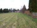
| + | Image:2011-03-12_45_-122-Field.jpg | The field where I thought the hashpoint was | ||
| + | Image:2011-03-12_45_-122-Gate1.jpg | The gate of the hashpoint field | ||
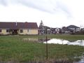
| + | Image:2011-03-12_45_-122-House.jpg | The view back towards the neighboring house | ||
| + | |||
</gallery> | </gallery> | ||
| Line 68: | Line 84: | ||
| − | |||
| − | |||
| − | |||
Revision as of 05:31, 13 March 2011

| Sat 12 Mar 2011 in 45,-122: 45.7281900, -122.6957004 geohashing.info google osm bing/os kml crox |
Location
A field near Vancouver, Washington right near a housing development
Participants
Plans
I have some errands to run, and then might run up there to see if I can get to the hashpoint.
Expedition
Well, after my errand, I headed up north of Portland to hunt for the hashpoint. After I crossed the Columbia River, I rechecked my directions and went up a few exits and got off the highway. I headed down a cross street which kept changing names without taking a turn - it was enough to make me think I was in New England.
Finally, I zipped past a little side street which turned out to be the one I wanted. I headed back and went the right way. Eventually the GPS reported we were 150 feet away. And there was a fence in the way.
I parked and looked over the situation. There was a gap between the houses, as Google Maps showed me, but there was no access from this side, as far as I could tell. I asked a neighbor who was getting into his car about access to the field, and he directed me to a house over a few streets.
I went to the house I thought I should, and walked up and knocked on the door. No answer.
I gave up and walked back to the car. Then I looked more closely at the field layout, and realized that maybe there was a different house to check with. I walked back to the main street from the cul-de-sac I was on and knocked on the door there. Still no answer.
As I turned to leave, a young woman emerged from the back of the house saying I was knocking at the door they didn't use. I explained what I was on a scavenger hunt, and that I wanted to their field. She said it belonged to the person who lived inside, and it was fine for me to go in.
So, I returned to the car, and switched to my Muck Boots, which proved to be a wise choice. I headed into what I thought was the field with a spring in my step, because I was going to get to a hashpoint for once. But it soon became very muddy and then very wet. Luckily, when one is wearing Muck Boots, one doesn't worry about such things. Soon I looked to my left, and realized there was a second field. Which belonged to the house I had first tried. I had a sinking feeling, and it wasn't from standing in a muddy field.
As I got to the end of the field, I looked at the GPS, hoping against hope. It was still about a hundred feet - back towards the street I had came from. The hashpoint really was in the "inbetween" field.
I took a picture of the gate from the front of the neighboring property back into the field that was holding the hashpoint and returned to my car. And drove back home.
Photos
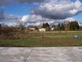
View towards the hashpoint from the street. Note the multiple fencelines.
View towards the hashpoint from the neighboring field

The field where I thought the hashpoint was
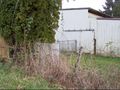
The gate of the hashpoint field
The view back towards the neighboring house


Achievements
- No Trespassing