Difference between revisions of "2011-04-11 40 -89"
imported>Dvdllr m (New exp page) |
imported>FippeBot m (Location) |
||
| (4 intermediate revisions by one other user not shown) | |||
| Line 1: | Line 1: | ||
| − | + | __NOTOC__ | |
| − | |||
| − | |||
| − | |||
| − | |||
| − | |||
| − | |||
| − | |||
| − | |||
| − | |||
{{meetup graticule | {{meetup graticule | ||
| lat=40 | | lat=40 | ||
| Line 14: | Line 5: | ||
| date=2011-04-11 | | date=2011-04-11 | ||
}} | }} | ||
| − | |||
| − | |||
| − | |||
== Location == | == Location == | ||
| − | + | Illinois Central College's North Campus, in Peoria. | |
== Participants == | == Participants == | ||
| − | + | * [[User:Dvdllr|Dvdllr]] | |
== Plans == | == Plans == | ||
| − | + | Drive there, park, walk to the spot, draw with chalk, take pictures, leave. Easy as pie! | |
== Expedition == | == Expedition == | ||
| − | + | I was so happy to see a geohash near the city that was actually reachable. This was the first expedition I'd been able to make so far this whole year, so it was indeed a delight. It was a place I've never been: Illinois Central College. The college's main campus is in East Peoria, but they have a few satellite campuses (campi?), this being "North Campus" in the city of Peoria. I didn't take the GPS along since it was easily locatable without one. The overhead view maps indicated it was at the end of one of those turn-around drop-off horseshoe dealies, whatever the proper term is. I arrived and parked around the north side of Arbor hall, and took the 45-second walk to the front of the building, to arrive at the hash point. I'd taken a stick of chalk along, purchased for this very purpose, to indicate where the spot was. I put a little "xkcd" bullseye on the spot, but also left a geohashing.org indication on the adjacent sidewalk. If you made it to this page from seeing the message, welcome! I took some pictures and left pretty quick. I had fun! | |
| − | |||
| − | |||
| − | |||
== Photos == | == Photos == | ||
| − | |||
| − | |||
| − | |||
<gallery perrow="5"> | <gallery perrow="5"> | ||
| + | Image:2011-04-11 40 -89 1.JPG | Entrance sign to the campus | ||
| + | Image:2011-04-11 40 -89 2.JPG | Pointing the way | ||
| + | Image:2011-04-11 40 -89 3.JPG | Arbor Hall | ||
| + | Image:2011-04-11 40 -89 4.JPG | I swear to you, this was supposed to be a bullseye, and not a boob. I didn't realize what I'd drawn until I was reviewing the pictures later that night. | ||
| + | Image:2011-04-11 40 -89 5.JPG | Helpful information | ||
| + | Image:2011-04-11 40 -89 6.JPG | Grinning geohasher | ||
| + | Image:2011-04-11 40 -89 7.JPG | The Scene | ||
</gallery> | </gallery> | ||
== Achievements == | == Achievements == | ||
{{#vardefine:ribbonwidth|800px}} | {{#vardefine:ribbonwidth|800px}} | ||
| − | + | {{land geohash | |
| + | | latitude = 40 | ||
| + | | longitude = -89 | ||
| + | | date = 2011-04-11 | ||
| + | | name = [[User:Dvdllr|Dvdllr]] | ||
| + | }} | ||
| + | {{No_batteries_geohash | ||
| − | + | | latitude = 40 | |
| − | + | | longitude = -89 | |
| − | [[ | + | | date = 2011-04-11 |
| + | | name = [[User:Dvdllr|Dvdllr]] | ||
| + | }} | ||
| + | {{Last man standing | ||
| − | + | | latitude = 40 | |
| − | + | | longitude = -89 | |
| − | [[ | + | | date = 2011-04-11 |
| − | + | | gender = man | |
| + | | name = [[User:Dvdllr|Dvdllr]] | ||
| + | }} | ||
| − | |||
[[Category:Expeditions]] | [[Category:Expeditions]] | ||
| − | |||
[[Category:Expeditions with photos]] | [[Category:Expeditions with photos]] | ||
| − | |||
[[Category:Expedition without GPS]] | [[Category:Expedition without GPS]] | ||
| − | |||
| − | |||
| − | |||
[[Category:Coordinates reached]] | [[Category:Coordinates reached]] | ||
| − | + | {{location|US|IL|PI}} | |
| − | |||
| − | |||
| − | |||
| − | |||
| − | |||
| − | |||
| − | |||
| − | |||
| − | |||
Latest revision as of 06:09, 9 August 2019
| Mon 11 Apr 2011 in 40,-89: 40.7535243, -89.6140133 geohashing.info google osm bing/os kml crox |
Location
Illinois Central College's North Campus, in Peoria.
Participants
Plans
Drive there, park, walk to the spot, draw with chalk, take pictures, leave. Easy as pie!
Expedition
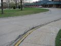
I was so happy to see a geohash near the city that was actually reachable. This was the first expedition I'd been able to make so far this whole year, so it was indeed a delight. It was a place I've never been: Illinois Central College. The college's main campus is in East Peoria, but they have a few satellite campuses (campi?), this being "North Campus" in the city of Peoria. I didn't take the GPS along since it was easily locatable without one. The overhead view maps indicated it was at the end of one of those turn-around drop-off horseshoe dealies, whatever the proper term is. I arrived and parked around the north side of Arbor hall, and took the 45-second walk to the front of the building, to arrive at the hash point. I'd taken a stick of chalk along, purchased for this very purpose, to indicate where the spot was. I put a little "xkcd" bullseye on the spot, but also left a geohashing.org indication on the adjacent sidewalk. If you made it to this page from seeing the message, welcome! I took some pictures and left pretty quick. I had fun!
Photos
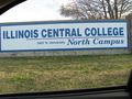
Entrance sign to the campus
Pointing the way
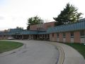
Arbor Hall
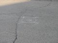
I swear to you, this was supposed to be a bullseye, and not a boob. I didn't realize what I'd drawn until I was reviewing the pictures later that night.
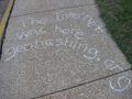
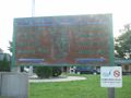
Helpful information

Grinning geohasher
The Scene


Achievements
Dvdllr earned the Land geohash achievement
|
Dvdllr earned the No Batteries Geohash Achievement
|
Dvdllr earned the Last man standing achievement
|