Difference between revisions of "2011-04-29 37 -76"
From Geohashing
imported>Jiml m (Adjust result codes) |
imported>Mampfred (cleanup) |
||
| Line 1: | Line 1: | ||
| − | |||
| − | |||
| − | |||
| − | |||
| − | |||
| − | |||
| − | |||
| − | |||
| − | |||
{{meetup graticule | {{meetup graticule | ||
| lat=37 | | lat=37 | ||
| Line 13: | Line 4: | ||
| date=2011-04-29 | | date=2011-04-29 | ||
}} | }} | ||
| − | |||
__NOTOC__ | __NOTOC__ | ||
== Location == | == Location == | ||
| − | |||
Near Newport News | Near Newport News | ||
== Participants == | == Participants == | ||
| − | |||
| − | |||
* [[User:Bob0the0mighty|Bob0the0mighty]] | * [[User:Bob0the0mighty|Bob0the0mighty]] | ||
| − | |||
| − | |||
| − | |||
| − | |||
== Expedition == | == Expedition == | ||
| − | + | Made it to a point for the first time in over a year. Glad it was so close. Anyone else active in the area? -- [[User:Bob0the0mighty|Bob0the0mighty]] [http://www.openstreetmap.org/?lat=37.05363958&lon=-76.39721362&zoom=16&layers=B000FTF @37.0536,-76.3972] 19:36, 29 April 2011 (EDT) | |
| − | |||
| − | |||
| − | |||
| − | |||
| − | |||
| − | |||
| − | |||
== Photos == | == Photos == | ||
| − | |||
| − | |||
| − | |||
<gallery perrow="5"> | <gallery perrow="5"> | ||
| − | |||
Image:2011-04-29_37_-76_19-35-15-110.jpg | Success again finally. Also upside down [http://www.openstreetmap.org/?lat=37.0533&lon=-76.3974&zoom=16&layers=B000FTF @37.0533,-76.3974] | Image:2011-04-29_37_-76_19-35-15-110.jpg | Success again finally. Also upside down [http://www.openstreetmap.org/?lat=37.0533&lon=-76.3974&zoom=16&layers=B000FTF @37.0533,-76.3974] | ||
</gallery> | </gallery> | ||
| Line 50: | Line 22: | ||
== Achievements == | == Achievements == | ||
{{#vardefine:ribbonwidth|800px}} | {{#vardefine:ribbonwidth|800px}} | ||
| − | + | {{Land geohash | |
| − | + | | latitude = 37 | |
| − | + | | longitude = -76 | |
| − | + | | date = 2011-04-29 | |
| − | + | | name = [[User:Bob0the0mighty|Bob0the0mighty]] | |
| − | + | }} | |
| − | |||
| − | |||
| − | [[ | ||
| − | |||
[[Category:Expeditions]] | [[Category:Expeditions]] | ||
| − | |||
[[Category:Expeditions with photos]] | [[Category:Expeditions with photos]] | ||
[[Category:Coordinates reached]] | [[Category:Coordinates reached]] | ||
Revision as of 18:08, 3 May 2011
| Fri 29 Apr 2011 in 37,-76: 37.0532816, -76.3973845 geohashing.info google osm bing/os kml crox |
Location
Near Newport News
Participants
Expedition
Made it to a point for the first time in over a year. Glad it was so close. Anyone else active in the area? -- Bob0the0mighty @37.0536,-76.3972 19:36, 29 April 2011 (EDT)
Photos
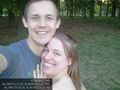
Success again finally. Also upside down @37.0533,-76.3974

Achievements
Bob0the0mighty earned the Land geohash achievement
|