Difference between revisions of "2011-05-25 50 10"
From Geohashing
imported>Mampfred |
imported>FippeBot m (Location) |
||
| (One intermediate revision by one other user not shown) | |||
| Line 18: | Line 18: | ||
== Expedition == | == Expedition == | ||
| − | + | Went there in the afternoon, straight forward drive, a bit of walking, found it 7 meters into a field. Rincewind went in and did the GPS dance for a while before settling for the 2m screenshot as we didn't want to destroy too much of the field. | |
== Tracklog == | == Tracklog == | ||
| − | + | See [http://www.everytrail.com/view_trip.php?trip_id=1108085 here]. | |
== Photos == | == Photos == | ||
| − | |||
| − | |||
| − | |||
<gallery perrow="5"> | <gallery perrow="5"> | ||
| + | Image:2011-05-25_50_10_rincewind.jpg | Rincewind going for the hash. | ||
| + | Image:2011-05-25_50_10_reached.jpg | Coordinates reached. | ||
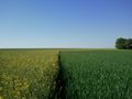
| + | Image:2011-05-25_50_10_ahead.jpg | Can you see the hash? | ||
| + | Image:2011-05-25_50_10_closeleft.jpg | The opposite direction. | ||
| + | Image:2011-05-25_50_10_left.jpg | To the left ... | ||
| + | Image:2011-05-25_50_10_right.jpg | ... and to the right. | ||
| + | Image:2011-05-25_50_10_rincewind_close.jpg | Rincewind and the hash. | ||
| + | Image:2011-05-25_50_10_grinflinch.jpg | Stupid Flinch/Grin. | ||
</gallery> | </gallery> | ||
== Achievements == | == Achievements == | ||
{{#vardefine:ribbonwidth|800px}} | {{#vardefine:ribbonwidth|800px}} | ||
| − | + | {{Land geohash | |
| + | | latitude = 50 | ||
| + | | longitude = 10 | ||
| + | | date = 2011-05-25 | ||
| + | | name = Mampfred and Rincewind | ||
| + | }} | ||
| − | |||
| − | |||
| − | |||
| − | |||
| − | |||
[[Category:Expeditions]] | [[Category:Expeditions]] | ||
| − | |||
[[Category:Expeditions with photos]] | [[Category:Expeditions with photos]] | ||
| − | |||
| − | |||
| − | |||
| − | |||
| − | |||
[[Category:Coordinates reached]] | [[Category:Coordinates reached]] | ||
| − | + | {{location|DE|TH|EF}} | |
| − | |||
| − | |||
| − | |||
| − | |||
| − | |||
| − | |||
| − | |||
| − | |||
| − | |||
Latest revision as of 06:40, 9 August 2019
| Wed 25 May 2011 in 50,10: 50.9313400, 10.9714522 geohashing.info google osm bing/os kml crox |
Location
Field near Erfurt.
Participants
Plans
Hash! Too close not to try it really ...
Expedition
Went there in the afternoon, straight forward drive, a bit of walking, found it 7 meters into a field. Rincewind went in and did the GPS dance for a while before settling for the 2m screenshot as we didn't want to destroy too much of the field.
Tracklog
See here.
Photos
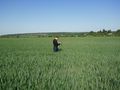
Rincewind going for the hash.
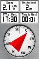
Coordinates reached.
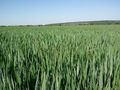
Can you see the hash?
The opposite direction.
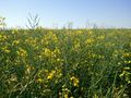
To the left ...

... and to the right.

Rincewind and the hash.

Stupid Flinch/Grin.


Achievements
Mampfred and Rincewind earned the Land geohash achievement
|