Difference between revisions of "2011-06-07 46 -92"
imported>Lefou m (→Photos) |
imported>FippeBot m (Location) |
||
| (4 intermediate revisions by 2 users not shown) | |||
| Line 14: | Line 14: | ||
}} | }} | ||
| − | + | ||
__NOTOC__ | __NOTOC__ | ||
== Location == | == Location == | ||
| − | + | ||
| + | Near Saginaw, MN, across from a truck weigh station and not far west of the crossroads of Highway 2 and Highway 33. | ||
== Participants == | == Participants == | ||
| − | + | ||
[[User:lefou|Le Fou]] plus one. | [[User:lefou|Le Fou]] plus one. | ||
== Plans == | == Plans == | ||
| − | + | ||
Looks like this landed in the middle of the westbound land of Highway 2, so I plan to drive over the point as fast as legally allowed. Then have coffee. I'll see if we can get photos while driving... | Looks like this landed in the middle of the westbound land of Highway 2, so I plan to drive over the point as fast as legally allowed. Then have coffee. I'll see if we can get photos while driving... | ||
== Expedition == | == Expedition == | ||
| − | + | ||
| + | Rather unremarkable. We packed for coffee, then drove to the hash point. I had a civilian navigator, who mislead us to a truck stop temporarily, where we witnessed some unabashed hugging (no photos to protect the innocent). A quick review of the geohash point told us it was a little further up the road. We drove over it, then pulled over to the shoulder and backed up next to it to get a shot of some near misses. If those other drivers only knew... | ||
== Tracklog == | == Tracklog == | ||
| Line 34: | Line 36: | ||
== Photos == | == Photos == | ||
| − | + | ||
| − | |||
| − | |||
<gallery perrow="5"> | <gallery perrow="5"> | ||
Image:Middle of the Road.jpg|Hashpoint is reportedly dead center of yellow stripe. | Image:Middle of the Road.jpg|Hashpoint is reportedly dead center of yellow stripe. | ||
| Line 45: | Line 45: | ||
<!-- Add any achievement ribbons you earned below, or remove this section --> | <!-- Add any achievement ribbons you earned below, or remove this section --> | ||
| + | * Land Geohash | ||
| + | * Speed Racer? | ||
| − | |||
| − | |||
| − | |||
| − | + | [[Category:Expeditions]] | |
| − | |||
| − | [[Category: | ||
| − | |||
| − | |||
| − | |||
| − | |||
[[Category:Expeditions with photos]] | [[Category:Expeditions with photos]] | ||
| − | |||
| − | |||
| − | |||
| − | + | ||
[[Category:Coordinates reached]] | [[Category:Coordinates reached]] | ||
| − | + | {{location|US|MN|ST}} | |
| − | |||
| − | |||
| − | |||
| − | |||
| − | |||
| − | |||
| − | |||
| − | |||
| − | |||
Latest revision as of 04:06, 6 August 2019
| Tue 7 Jun 2011 in Duluth: 46.8462235, -92.4653065 geohashing.info google osm bing/os kml crox |
Location
Near Saginaw, MN, across from a truck weigh station and not far west of the crossroads of Highway 2 and Highway 33.
Participants
Le Fou plus one.
Plans
Looks like this landed in the middle of the westbound land of Highway 2, so I plan to drive over the point as fast as legally allowed. Then have coffee. I'll see if we can get photos while driving...
Expedition
Rather unremarkable. We packed for coffee, then drove to the hash point. I had a civilian navigator, who mislead us to a truck stop temporarily, where we witnessed some unabashed hugging (no photos to protect the innocent). A quick review of the geohash point told us it was a little further up the road. We drove over it, then pulled over to the shoulder and backed up next to it to get a shot of some near misses. If those other drivers only knew...
Tracklog
Photos
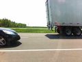
Hashpoint is reportedly dead center of yellow stripe.

Achievements
- Land Geohash
- Speed Racer?