Difference between revisions of "2011-07-03 -38 144"
imported>Taner (Created page) |
imported>FippeBot m (Location) |
||
| Line 38: | Line 38: | ||
[[Category:Water geohash achievement]] | [[Category:Water geohash achievement]] | ||
[[Category:Coordinates reached]] | [[Category:Coordinates reached]] | ||
| + | {{location|AU|VIC}} | ||
Latest revision as of 06:58, 9 August 2019
| Sun 3 Jul 2011 in -38,144: -38.1440572, 144.5689717 geohashing.info google osm bing/os kml crox |
Contents
Location
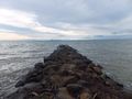
300 metres into the sea at Clifton Springs
Who went
Expedition
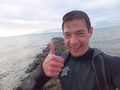
Swimming!.
Again, a small detour from the return leg of my weekend away. Had the wettie with me so couldn't pass up the opportunity for some more swimming!
Unfortunately I didn't have enough confidence in my dry sack to take my camera as well with me, but not that it mattered as it also turns out it is a challenging feat to open up a backpack, a dry sack, and then use the GPS and/or a camera without getting them wet. And not being cheap pieces of equipment, I decided against it. This also means that I may have only been within 20m of the geohash, so I would call this a semi-successful attempt. Once I learn how to use the GPS a little more, I will see if I can view the route and check how close I got.
Got a weird stare from someone as I was about to descend into the cliffs carrying a wetsuit and a backpack, met a father and daughter with their dog near the beach who didn't think much of what was going on and got a compliment for being in the water on the way back to the car, apparently swimming at the beach isn't a common winter activity! Much more interaction than the two previous geohash missions!
Photos
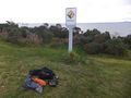
Gear: A dry sack, backpack, GPS, camera, wetsuit, fivefingers and a towel
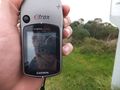
GPS on shore
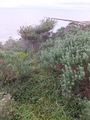
Hastily chosen spot to descend
Pfft!
Lines up with the geohash!!
Drowned rat!
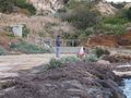
A more sane activity of walking the dog


