Difference between revisions of "2011-07-04 66 25"
From Geohashing
imported>Isopekka (Created page with "thumb|left {{meetup graticule | lat=66 | lon=25 | date=2011-07-04 }} == Location == About 5 km to the SE from my home, in Paavalniemi, on t...") |
(No difference)
|
Revision as of 14:55, 4 July 2011

| Mon 4 Jul 2011 in 66,25: 66.4696023, 25.6514400 geohashing.info google osm bing/os kml crox |
Contents
Location
About 5 km to the SE from my home, in Paavalniemi, on the wet shore of the river Kemijoki.
Plan
I will check if I can reach this maybe wet hashpoint.
Participants
Expedition
- By car total 10 km
- Walking total 1 km
- Expedition took 0.5 h
- Physical effort (1-5):2
Photos
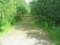
Along this road...
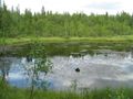
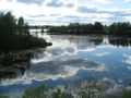
There it is, on the other side of this water.
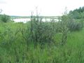
The Hashbush.
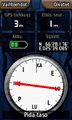
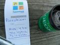
The Proof.
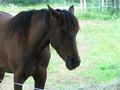
The Hash Horse on the way to the geocache.
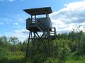
The Birdtower of Paavalniemi.
The Geocache GCVWW9.
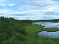
The view from the birdtower towards the hashpoint.
The view to the opposite direction.


Achievements
isopekka earned the Land geohash achievement
|
isopekka earned the Hash collision honorable mention
|
Geohashing Expeditions and Plans on This Day
Expeditions and Plans
| 2011-06-24 | ||
|---|---|---|
| Schweinfurt, Germany | Juja's | In the forest between Neundorf and Steinbach, not far away from "Hohe Straß... |
| Sheffield, United Kingdom | Monty | Moorland, just inside the Peak District national park, southwest of Holmfir... |
| Rovaniemi, Finland | isopekka | About 5 km to the NE from my home, in Nivankylä, near private houses. |