Difference between revisions of "2011-07-19 59 18"
imported>Per Scheffer (→Expedition) |
imported>Per Scheffer |
||
| Line 40: | Line 40: | ||
== Achievements == | == Achievements == | ||
{{#vardefine:ribbonwidth|800px}} | {{#vardefine:ribbonwidth|800px}} | ||
| − | + | {{land geohash | |
| + | | latitude = 59 | ||
| + | | longitude = 18 | ||
| + | | date = 2011-07-19 | ||
| + | | name = Per Scheffer | ||
| + | | image = 2011-07-19 59 18 The Geohasher.jpg | ||
| + | }} | ||
| − | |||
| − | |||
| − | |||
| − | |||
| − | |||
| − | |||
| − | |||
| − | |||
| − | |||
| − | |||
| − | |||
[[Category:Expeditions]] | [[Category:Expeditions]] | ||
| − | |||
[[Category:Expeditions with photos]] | [[Category:Expeditions with photos]] | ||
| − | |||
| − | |||
| − | |||
| − | |||
| − | |||
[[Category:Coordinates reached]] | [[Category:Coordinates reached]] | ||
| − | + | [[Category:Land_geohash_achievement]] | |
| − | |||
| − | |||
| − | |||
| − | |||
| − | |||
| − | |||
| − | |||
| − | [[Category: | ||
| − | |||
Revision as of 10:52, 20 July 2011

| Tue 19 Jul 2011 in Stockholm: 59.9844916, 18.0788194 geohashing.info google osm bing/os kml crox |
Location
In the middle of a field outside of Alunda, Sweden.
Participants
Plans
To drive as close as possible using my phone's GPS navigation and then walk the final stretch guided by Google Maps. Hopefully I get an adventure on the way.
Expedition
The drive was about 45 miles and nothing much happened on the way. I listened to the radio and followed the navigation instructions. I parked the car and stepped out into the field and was immediately attacked by a swarm of flies. They followed me loyally in the heat the whole way to the hashpoint and back. Fortunately, the field was recently harvested, which made walking easy.
The hashpoint was in a thicket of brambles and nettles just outside of the harvested area.
On the way back I decided to save my phones battery and follow the road signs instead. This lead me onto a different road, which runs east of Arlanda airport. Suddenly i passed a lake surrounded by some kind of towers and I remembered that they recently opened a wakeboard cable park in that area. I turned back i the next roundabout and stopped at the cable park. There I met a couple of people i know from before and they talked me into a session. I hadn't brought any swimming shorts, so to everyone's amusement i rode in my boxers.
So I also got my adventure!
Photos
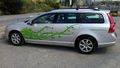
The transportation
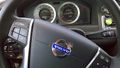
The transportation
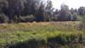
The hashpoint
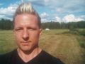
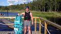
The geohasher at the hashpoint
The adventure


Achievements
Per Scheffer earned the Land geohash achievement
|