Difference between revisions of "2011-07-23 55 85"
imported>LemonadeCellar (Created page with "{{subst:Expedition |lat = 55 |lon = 85 |date = 2011-07-23 }}") |
imported>FippeBot m (Location) |
||
| (5 intermediate revisions by one other user not shown) | |||
| Line 1: | Line 1: | ||
| − | + | [[Image:{{{image|2011_07_23_55_85_house_med.jpg}}}|thumb|left]] | |
| − | |||
| − | |||
| − | [[Image:{{{image| | ||
| − | |||
| − | |||
| − | |||
| − | |||
| − | |||
| − | |||
{{meetup graticule | {{meetup graticule | ||
| lat=55 | | lat=55 | ||
| Line 15: | Line 6: | ||
}} | }} | ||
| − | + | ||
__NOTOC__ | __NOTOC__ | ||
== Location == | == Location == | ||
| − | + | A forest (presumably, the satellite image isn't exactly high-res, the only thing known for sure is that it's something green) near a village called Medynino. | |
== Participants == | == Participants == | ||
| − | + | [[User:LemonadeCellar|LemonadeCellar]] and his friend called Alexander. | |
== Plans == | == Plans == | ||
| − | + | Get there by bus (as if [[User:LemonadeCellar|LemonadeCellar]] has any other options), ask locals if there are any bears in the woods, run away like little girls if told "yes", otherwise try to reach the coordinates at 4 PM. | |
== Expedition == | == Expedition == | ||
| − | + | Well, this one was just FUBAR. | |
| + | |||
| + | Before I start, I should explain something. The navigation app I have installed on my phone (Mappero) doesn't have it's own collection of maps; instead, it downloads them from the Internet. There are several options to choose from (Google, Yandex, Virtual Earth and Open Street). I mostly use Google Satellite. | ||
| + | |||
| + | The initial part (getting on the bus) went fine, although we almost missed it (had to run like never before). The one and a half hour long bus ride was boring, until we noticed that we were getting further away from Tom River when we were supposed to get closer to it. Well, what do think? It turned out that the village near the graticule was actually Podonino, and we arrived at Medynino, which is about 15 km away from it. The bus driver was kind enough to give us a lift back to the crossing, but we didn't realize that we should drive all the way to Glubokoye on it, so we had to walk there (about 4 km, then another kind person gave us a lift). Since the initial plan was to take a bus from Medynino, and buses don't go to Podonino, I proposed to stay in Glubokoye and wait for the next bus to Kemerovo, but Alexander wanted to get to the hashpoint at any cost. We started walking to Podonino (8 km according to the sign) and soon encountered a fork in the road: it split into an asphalt-paved road, and one without any coating, which was cleared by cars. I chose the latter one, which turned out to be a dumb decision. We walked for some time, chose roads on crossings, crossed a brook with our shoes taken off, and soon came to the end of that so-called "road". The smart thing to do would be to give up, get back in our own tracks and leave by bus, but I was willing to fight with the local vegetation to get to the next road and went forward. In retrospect, this was the most idiotic decision I've made in my entire life. As you probably guessed, it did not go well. The further we went, the denser and higher the vegetation became, there was no sign of roads, the nettle was stinging us in the hands and the legs, and there was a swarm of insects ready to suck our blood if we stopped waving them off even for a second. For the first time in this expedition, I made a smart decision and turned in the direction of the asphalt-paved road. After an our of fighting Mother Nature we finally got to the road, completely exhausted. (We also had to cross that brook again, this time by a trunk of a knocked down birch.) When we finally got to Podonino, we were already late for the last bus from Pod"yakovo (a village across Tom River), but even if we weren't late, we wouldn't be able to get there, because the yellow line connecting Podonino and Pod"yakovo through the river which was present both on Google Maps and Virtual Earth, which I expected to be a bridge or some other kind of river crossing, turned out to be nothing. Afer hearing about what happend to us, some friends of Alexander volunteered to drive to Glubokoye and pick us up (which was very nice of them). We got a speedy lift to Glubokoye from yet another kind person, and, after another ride (this time in the twilight) finally got home. | ||
== Tracklog == | == Tracklog == | ||
| − | + | [http://www.everytrail.com/view_trip.php?trip_id=1205345 Here]. To get an accurate picture, swap Medynino with Podonino and vice versa. I have filed a report to Geocentre Consulting about the wrong data; hopefully, they'll fix it. | |
== Photos == | == Photos == | ||
| Line 37: | Line 32: | ||
--> | --> | ||
<gallery perrow="5"> | <gallery perrow="5"> | ||
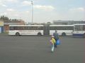
| + | Image:2011_07_23_55_85_bus.jpg | Our ride is the one on the left. | ||
| + | Image:2011_07_23_55_85_bus_entrance.jpg | A lot of people are going to counryside for the weekend. | ||
| + | Image:2011_07_23_55_85_house_med.jpg | A house in Medynino. | ||
| + | Image:2011_07_23_55_85_zapor.jpg | A [http://en.wikipedia.org/wiki/Zaporozhets Zaporozhets]. These cars were wildly popular in USSR, you know. | ||
| + | Image:2011_07_23_55_85_green.jpg | Lots and lots of green. Just like the satellite image promised. | ||
| + | Image:2011_07_23_55_85_cow.jpg | A cow. Well, it seemed interesting to me, since I have never seen one before in my life. | ||
| + | Image:2011_07_23_55_85_no_digging.jpg | The sign says "No digging! Cable guard zone." Apparently, it's a telephone line. | ||
| + | Image:2011_07_23_55_85_tractor.jpg | Agricultural hardware. | ||
| + | Image:2011_07_23_55_85_school.jpg | A local elementary school. Well, at least there is a school, could be worse. | ||
| + | Image:2011_07_23_55_85_brook.jpg | This brook is evil, I tell you, evil! | ||
</gallery> | </gallery> | ||
| − | |||
| − | |||
| − | |||
| − | |||
| − | |||
| − | |||
| − | |||
| − | |||
| − | |||
| − | |||
| − | |||
| − | |||
| − | |||
| − | |||
| − | |||
[[Category:Expeditions]] | [[Category:Expeditions]] | ||
| − | |||
[[Category:Expeditions with photos]] | [[Category:Expeditions with photos]] | ||
| − | |||
| − | |||
| − | |||
| − | |||
| − | |||
| − | |||
| − | |||
| − | |||
| − | |||
[[Category:Coordinates not reached]] | [[Category:Coordinates not reached]] | ||
| − | + | [[Category:Not reached - Mother Nature]] | |
| − | [[Category:Not reached - Mother Nature]] | + | [[Category:Not reached - Technology]] |
| − | + | {{location|RU|KEM}} | |
| − | [[Category:Not reached - Technology]] | ||
| − | |||
| − | |||
Latest revision as of 04:11, 6 August 2019

| Sat 23 Jul 2011 in 55,85: 55.5636684, 85.8014119 geohashing.info google osm bing/os kml crox |
Location
A forest (presumably, the satellite image isn't exactly high-res, the only thing known for sure is that it's something green) near a village called Medynino.
Participants
LemonadeCellar and his friend called Alexander.
Plans
Get there by bus (as if LemonadeCellar has any other options), ask locals if there are any bears in the woods, run away like little girls if told "yes", otherwise try to reach the coordinates at 4 PM.
Expedition
Well, this one was just FUBAR.
Before I start, I should explain something. The navigation app I have installed on my phone (Mappero) doesn't have it's own collection of maps; instead, it downloads them from the Internet. There are several options to choose from (Google, Yandex, Virtual Earth and Open Street). I mostly use Google Satellite.
The initial part (getting on the bus) went fine, although we almost missed it (had to run like never before). The one and a half hour long bus ride was boring, until we noticed that we were getting further away from Tom River when we were supposed to get closer to it. Well, what do think? It turned out that the village near the graticule was actually Podonino, and we arrived at Medynino, which is about 15 km away from it. The bus driver was kind enough to give us a lift back to the crossing, but we didn't realize that we should drive all the way to Glubokoye on it, so we had to walk there (about 4 km, then another kind person gave us a lift). Since the initial plan was to take a bus from Medynino, and buses don't go to Podonino, I proposed to stay in Glubokoye and wait for the next bus to Kemerovo, but Alexander wanted to get to the hashpoint at any cost. We started walking to Podonino (8 km according to the sign) and soon encountered a fork in the road: it split into an asphalt-paved road, and one without any coating, which was cleared by cars. I chose the latter one, which turned out to be a dumb decision. We walked for some time, chose roads on crossings, crossed a brook with our shoes taken off, and soon came to the end of that so-called "road". The smart thing to do would be to give up, get back in our own tracks and leave by bus, but I was willing to fight with the local vegetation to get to the next road and went forward. In retrospect, this was the most idiotic decision I've made in my entire life. As you probably guessed, it did not go well. The further we went, the denser and higher the vegetation became, there was no sign of roads, the nettle was stinging us in the hands and the legs, and there was a swarm of insects ready to suck our blood if we stopped waving them off even for a second. For the first time in this expedition, I made a smart decision and turned in the direction of the asphalt-paved road. After an our of fighting Mother Nature we finally got to the road, completely exhausted. (We also had to cross that brook again, this time by a trunk of a knocked down birch.) When we finally got to Podonino, we were already late for the last bus from Pod"yakovo (a village across Tom River), but even if we weren't late, we wouldn't be able to get there, because the yellow line connecting Podonino and Pod"yakovo through the river which was present both on Google Maps and Virtual Earth, which I expected to be a bridge or some other kind of river crossing, turned out to be nothing. Afer hearing about what happend to us, some friends of Alexander volunteered to drive to Glubokoye and pick us up (which was very nice of them). We got a speedy lift to Glubokoye from yet another kind person, and, after another ride (this time in the twilight) finally got home.
Tracklog
Here. To get an accurate picture, swap Medynino with Podonino and vice versa. I have filed a report to Geocentre Consulting about the wrong data; hopefully, they'll fix it.
Photos
Our ride is the one on the left.

A lot of people are going to counryside for the weekend.
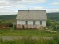
A house in Medynino.
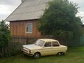
A Zaporozhets. These cars were wildly popular in USSR, you know.

Lots and lots of green. Just like the satellite image promised.
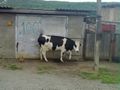
A cow. Well, it seemed interesting to me, since I have never seen one before in my life.

The sign says "No digging! Cable guard zone." Apparently, it's a telephone line.
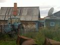
Agricultural hardware.

A local elementary school. Well, at least there is a school, could be worse.
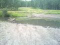
This brook is evil, I tell you, evil!


