Difference between revisions of "2011-08-02 51 12"
From Geohashing
imported>Reinhard (report) |
imported>FippeBot m (Location) |
||
| (One intermediate revision by one other user not shown) | |||
| Line 20: | Line 20: | ||
== Photos == | == Photos == | ||
{{gallery|width=200|height=200|lines=2 | {{gallery|width=200|height=200|lines=2 | ||
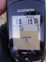
| − | |Image:20110802-51N12E-01.jpg| | + | |Image:20110802-51N12E-01.jpg|Coordinates reached. |
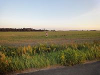
| − | |Image:20110802-51N12E-02.jpg| | + | |Image:20110802-51N12E-02.jpg|Reinhard and Manu at hash. |
| − | |Image:20110802-51N12E-03.jpg| | + | |Image:20110802-51N12E-03.jpg|Manu coming back from hash. |
}} | }} | ||
| Line 28: | Line 28: | ||
[[Category:Expeditions with photos]] | [[Category:Expeditions with photos]] | ||
[[Category:Coordinates reached]] | [[Category:Coordinates reached]] | ||
| + | {{location|DE|SN|TDO}} | ||
Latest revision as of 00:18, 13 August 2019
| Tue 2 Aug 2011 in 51,12: 51.5473116, 12.5236232 geohashing.info google osm bing/os kml crox |
Location
Some meters into a field near Brösen, north of Leipzig.
Participants
Expedition
Reinhard drove to Leipzig after work to visit Manu and to go on a geohash bike ride together with her. (copypasting the last expeditions again ...)
This time the hashpoint was even further from Manu's home, which lead to the decision to leave Leipzig by car (driving 19 km) and go on a shorter bike round trip (41 km) from Mocherwitz, so it wouldn't get too late and dark. The hashpoint was found about 30 m into a field, which wasn't clearly to recognize as being planted or not planted, which is why Manu and Reinhard set their steps carefully between the small and unknown plants. Coordinates reached.
Photos
|


