Difference between revisions of "2011-08-03 45 -122"
(→Expedition) |
imported>Kydlt (→Photos) |
||
| Line 46: | Line 46: | ||
--> | --> | ||
<gallery perrow="5"> | <gallery perrow="5"> | ||
| + | Image:2011-08-03 45 -122 1_10 ft circle.jpg | somewheres close | ||
| + | Image:2011-08-03 45 -122 2_flag.jpg | I left a mark. | ||
| + | Image:2011-08-03 45 -122 3_available.jpg | I have no affiliation with this company. | ||
</gallery> | </gallery> | ||
Revision as of 19:40, 3 August 2011
| Wed 3 Aug 2011 in 45,-122: 45.5510949, -122.4186222 geohashing.info google osm bing/os kml crox |
Location
Just off the N side of I-84 between exit 16 &17. If the Google street view is current, it is an empty lot between Sigler's Marine (1774 Northwest Commerce Court) and the Troutdale airport.
Participants
- Kydlt
Plans
Today's Portland Geohash looks like it's getting a visit. It is at 45.551094°, -122.418623°, just off the N side of I-84 between exit 16 &17. If the Google street view is current, it is an empty lot between Sigler's Marine (1774 Northwest Commerce Court) and the Troutdale airport. And I go into Portland later this morning,
Expedition
I stopped by on my way into Portland. Very boring spot, but as the sign says, it is available. There was also a small 'no trespassing, no dumping' sign but I didn't see it. Besides, how can somewhere be available, unfenced and posted ? I left a small flag so I guess that I will stop on my way home to collect it.
Tracklog
Photos
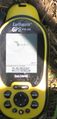
somewheres close
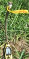
I left a mark.
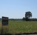
I have no affiliation with this company.


Achievements