Difference between revisions of "2011-08-16 48 9"
imported>Steingesicht |
imported>FippeBot m (Location) |
||
| (8 intermediate revisions by 2 users not shown) | |||
| Line 10: | Line 10: | ||
== Participants == | == Participants == | ||
| + | |||
| + | [[User:Ekorren|Ekorren]] was there in the afternoon. | ||
[[User:Steingesicht|Steingesicht]] went to Mittelstadt between 19:00 and 20:00 local time. | [[User:Steingesicht|Steingesicht]] went to Mittelstadt between 19:00 and 20:00 local time. | ||
| + | == Expeditions == | ||
| + | === Ekorren === | ||
| − | + | I raced down the Neckar valley cycle trail by bike, which is a really beaten trail for me. Circled the hash but didn't ''really'' think I reached it - whatever the accuracy of the GPS was, I would rather believe that the exact point was on the private lot above the wall. However, it was so close that even that might be disputable - still, the GPS dance never pointed in another direction and never came closer than 2m. | |
| − | |||
| − | |||
| + | === Steingesicht === | ||
| + | My plan was to combine the geohashing expedition with a hunt for a geocache. | ||
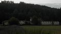
| + | I went to Mittelstadt by car. I parked the car outside Mittelstadt and start my expedition by foot. I started with some multi-cache stages of the cache [http://coord.info/GC2W77J Geesfiaß - Gänsefüße] and between two stages I visited the hash of this day. | ||
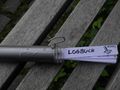
| + | The hash was in a bushy corner of a small public green, surrounded by a well an a small brook. I left a geohashing marker at the site. | ||
| + | After the visit I completed the geocache - and was really surprised: the final of the geocache was nearly in the same place like the geohash. According to my GPSr, the distance is 11m - this is less than the usual measuring accuracy of 15m! This was really amazing. So I could log a geocache and a geohash at the same place. | ||
== Gallery == | == Gallery == | ||
| + | === Ekorren === | ||
| + | <gallery> | ||
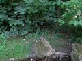
| + | File:2011-08-16_48_9_garden.JPG|Hashpoint from above... | ||
| + | File:2011-08-16_48_9_park.JPG|... and below | ||
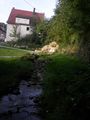
| + | File:2011-08-16_48_9_creek.JPG|Near hash | ||
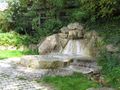
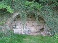
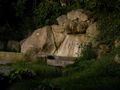
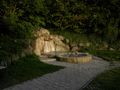
| + | File:2011-08-16_48_9_fountain.JPG | ||
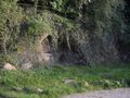
| + | File:2011-08-16_48_9_cellar.JPG | ||
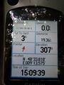
| + | File:2011-08-16_48_9_GPS.JPG|Quite close, but still rather at the wrong end of the wall... | ||
| + | File:2011-08-16_48_9_flower_1.JPG|Flowers near hash | ||
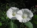
| + | File:2011-08-16_48_9_flower_2.JPG | ||
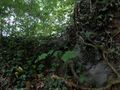
| + | File:2011-08-16_48_9_landscape_1.JPG|random landscape impressions | ||
| + | File:2011-08-16_48_9_landscape_2.JPG | ||
| + | </gallery> | ||
| + | === Steingesicht === | ||
<gallery> | <gallery> | ||
| + | File:2011-08-16_48_9_01.jpeg|View at Mittelstadt | ||
| + | File:2011-08-16_48_9_02.jpeg|nearest point | ||
| + | File:2011-08-16_48_9_03.jpeg|nearest point | ||
| + | File:2011-08-16_48_9_04.jpeg|the hash point | ||
| + | File:2011-08-16_48_9_05.jpeg|well and brook | ||
| + | File:2011-08-16_48_9_06.jpeg|well | ||
| + | File:2011-08-16_48_9_07.jpeg|marker | ||
| + | File:2011-08-16_48_9_08.jpeg|well | ||
| + | File:2011-08-16_48_9_09.jpeg|hole in the wall | ||
| + | File:2011-08-16_48_9_10.jpeg|houses | ||
| + | File:2011-08-16_48_9_11.jpeg|bells | ||
| + | File:2011-08-16_48_9_12.jpeg|St. Martinus | ||
| + | File:2011-08-16_48_9_13.jpeg|GC2W77J Logbook | ||
| + | File:2011-08-16_48_9_14.jpeg|old factory | ||
</gallery> | </gallery> | ||
| + | == Achievements == | ||
| + | {{Hash collision | latitude = 48 | longitude = 9 | date = 2011-08-16 | name = Steingesicht | link = http://coord.info/GC2W77J | id = GC2W77J | distance = 11 m }} | ||
| + | |||
[[Category:Expeditions]] | [[Category:Expeditions]] | ||
[[Category:Expeditions with photos]] | [[Category:Expeditions with photos]] | ||
[[Category:Coordinates reached]] | [[Category:Coordinates reached]] | ||
| − | |||
| − | |||
[[Category:Expeditions_with_marker]] | [[Category:Expeditions_with_marker]] | ||
| + | [[Category:Hash_collision_achievement]] | ||
| + | {{location|DE|BW|RT}} | ||
Latest revision as of 00:27, 13 August 2019
| Tue 16 Aug 2011 in 48,9: 48.5636154, 9.2262501 geohashing.info google osm bing/os kml crox |
Contents
Location
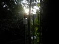
Mittelstadt, near Reutlingen. A place near the main road, a small public green with a well feeding a small brook. The exact point was probaly on private property. But it was possible to approach less than 10m on public ground - in consideration of the measuring accuracy the hash-point was reached.
Participants
Ekorren was there in the afternoon.
Steingesicht went to Mittelstadt between 19:00 and 20:00 local time.
Expeditions
Ekorren
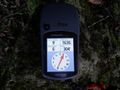
I raced down the Neckar valley cycle trail by bike, which is a really beaten trail for me. Circled the hash but didn't really think I reached it - whatever the accuracy of the GPS was, I would rather believe that the exact point was on the private lot above the wall. However, it was so close that even that might be disputable - still, the GPS dance never pointed in another direction and never came closer than 2m.
Steingesicht
My plan was to combine the geohashing expedition with a hunt for a geocache. I went to Mittelstadt by car. I parked the car outside Mittelstadt and start my expedition by foot. I started with some multi-cache stages of the cache Geesfiaß - Gänsefüße and between two stages I visited the hash of this day. The hash was in a bushy corner of a small public green, surrounded by a well an a small brook. I left a geohashing marker at the site. After the visit I completed the geocache - and was really surprised: the final of the geocache was nearly in the same place like the geohash. According to my GPSr, the distance is 11m - this is less than the usual measuring accuracy of 15m! This was really amazing. So I could log a geocache and a geohash at the same place.
Gallery
Ekorren
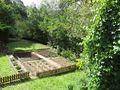
Hashpoint from above...
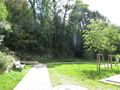
... and below
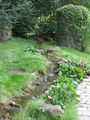
Near hash
Quite close, but still rather at the wrong end of the wall...
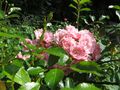
Flowers near hash
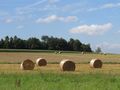
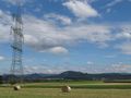
random landscape impressions


Steingesicht
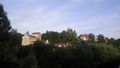
View at Mittelstadt
nearest point
nearest point
the hash point
well and brook
well
marker
well
hole in the wall
houses
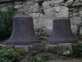
bells
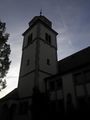
St. Martinus
GC2W77J Logbook
old factory


Achievements
Steingesicht earned the Hash collision achievement
|