Difference between revisions of "2011-08-20 46 6"
From Geohashing
imported>Nohled |
imported>Nohled |
||
| Line 30: | Line 30: | ||
== Photos == | == Photos == | ||
<gallery perrow="5"> | <gallery perrow="5"> | ||
| − | Image:2011-08-20 46 6 bad cellphone.jpg | I'm sure to have stayed on the | + | Image:2011-08-20 46 6 bad cellphone.jpg | I'm sure to have stayed on the ground... |
Image:2011-08-20 46 6 supposed geohash.jpg | The geohash should have been close to these stones based on satellite maps. | Image:2011-08-20 46 6 supposed geohash.jpg | The geohash should have been close to these stones based on satellite maps. | ||
Image:2011-08-20 46 6 view.jpg | View of the Lake Léman. | Image:2011-08-20 46 6 view.jpg | View of the Lake Léman. | ||
Revision as of 16:36, 20 August 2011
| Sat 20 Aug 2011 in 46,6: 46.4892674, 6.7423110 geohashing.info google osm bing/os kml crox |
Location
On the shore of Lake Léman, between Cully and Epesses.
Participants
Plans
Take the train to Cully and then walk to the geohash.
Expedition
Reached the geohash surroundings without problems. However, I failed to precisely localize the hash due to my bad GPS cellphone. It kept telling me I was in the lake although I was pretty sure I stayed on the ground. Even so, I should have been very close to the destination based on satellite maps.
Photos
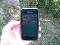
I'm sure to have stayed on the ground...
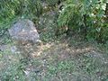
The geohash should have been close to these stones based on satellite maps.
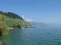
View of the Lake Léman.


Achievements
Nohled earned the Blinded by Science Consolation Prize
|