Difference between revisions of "2011-08-23 47 11"
From Geohashing
imported>Robert (→Location) |
imported>Robert (→Photos) |
||
| Line 24: | Line 24: | ||
Image:Img-08 23 18 0822.jpg | Yep. Getting very muddy here, so... | Image:Img-08 23 18 0822.jpg | Yep. Getting very muddy here, so... | ||
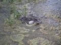
Image:Img-13 23 18 1328.jpg | Using highly precise guessing this stone marks the actual hashpoint. As it sank within 30sec, i decided not to verify its position... | Image:Img-13 23 18 1328.jpg | Using highly precise guessing this stone marks the actual hashpoint. As it sank within 30sec, i decided not to verify its position... | ||
| + | Image:Img-12 23 18 1227.jpg | looking stupid (and a bit done on a very hot day) | ||
</gallery> | </gallery> | ||
Revision as of 22:49, 30 August 2011
| Tue 23 Aug 2011 in 47,11: 47.8504026, 11.5344730 geohashing.info google osm bing/os kml crox |
Location
Somewhere in between Geretsried and Dietramszell
Participants
Expedition
Got there by bike, about 30km from my place, didnt take the same way back so i ended up with around 80km and an 24km/hr average, which i decided to be enough for a 30-35°C day.
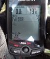
Tracklog
exists.
Photos
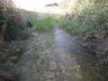
Really muddy place
Yep. Getting very muddy here, so...
Using highly precise guessing this stone marks the actual hashpoint. As it sank within 30sec, i decided not to verify its position...

looking stupid (and a bit done on a very hot day)


