Difference between revisions of "2011-08-25 44 -92"
imported>RocketMac (→Achievements) |
imported>Jiml m (Adjust result codes) |
||
| Line 6: | Line 6: | ||
tag from your image file name, and replace the all upper-case word IMAGE in the above line. | tag from your image file name, and replace the all upper-case word IMAGE in the above line. | ||
| − | And DON'T FORGET to add your expedition and the best photo you took to the gallery on the Main Page! We'd love to read your | + | And DON'T FORGET to add your expedition and the best photo you took to the gallery on the Main Page! We'd love to read your repo rt, but that means we first have to discover it! |
--> | --> | ||
{{meetup graticule | {{meetup graticule | ||
| Line 45: | Line 45: | ||
Image:2011-08-26 44 -92 03.png | Distance from the hashpoint | Image:2011-08-26 44 -92 03.png | Distance from the hashpoint | ||
</gallery> | </gallery> | ||
| + | |||
| + | |||
| + | <!-- Not if didn't reach it, sorry. | ||
== Achievements == | == Achievements == | ||
{{#vardefine:ribbonwidth|800px}} | {{#vardefine:ribbonwidth|800px}} | ||
| + | |||
{{land geohash | {{land geohash | ||
| Line 56: | Line 60: | ||
| image = | | image = | ||
}} | }} | ||
| + | --> | ||
| − | |||
| + | [[Category:Expeditions with photos]] | ||
| − | |||
| − | |||
| − | |||
| − | |||
| − | |||
| − | |||
| − | |||
| − | |||
| − | |||
| − | |||
| − | |||
[[Category:Expeditions]] | [[Category:Expeditions]] | ||
| − | |||
| − | |||
| − | |||
| − | |||
| − | |||
| − | |||
| − | |||
| − | |||
[[Category:Not reached - Mother Nature]] | [[Category:Not reached - Mother Nature]] | ||
| − | + | ||
[[Category:Coordinates not reached]] | [[Category:Coordinates not reached]] | ||
| − | |||
| − | |||
| − | |||
| − | |||
| − | |||
| − | |||
Revision as of 14:21, 27 August 2011
| Thu 25 Aug 2011 in 44,-92: 44.7747264, -92.0248838 geohashing.info google osm bing/os kml crox |
Contents
[hide]Location
A corn field on a small road off a small road off a small road off the freeway.
Participants
RocketMac - Heading home from Minneapolis to Milwaukee
Plans
The trip on Monday went so well, I decided to see if I could hit any hashpoints on the way back. Only two were within a reasonable distance. It was going to be later in the evening maybe even dark, but I decided to try.
Expedition
My departure from Minneapolis had been delayed by the worse traffic (2 miles in 25 minutes at one point) and then with a longer than planned dinner stop at Psycho Suzi's Motor Lounge which put me at the nearest freeway exit approaching dusk.
After the freeway it was one side road after another and another each lasting longer and longer. It was getting darker and I didn't know if I would be there before dark.
When I reached the spot, I realized what I was seeing on the map between the road and the hashpoint. Corn. And lots of it.
The advantage of all those delays in town and the twists and turns away from the main roads was the sky. Without the light pollution, the night sky was full of stars.
Tracklog
My log for the trip is available in GPX and KMZ formats
Photos
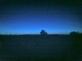
A starry night over the top of a corn field
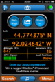
GPS reading of where I was standing
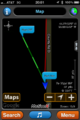
Distance from the hashpoint


