Difference between revisions of "2011-09-17 31 -110"
From Geohashing
imported>Wyle & RoadRunner (Created page with "{{meetup graticule | lat=31 | lon=-110 | date=2011-09-17 | graticule_name=Nogales | graticule_link=Nogales, Arizona}} == Location == Just off the road to Madera Canyon == Part...") |
imported>FippeBot m (Location) |
||
| Line 26: | Line 26: | ||
[[Category:Expeditions with photos]] | [[Category:Expeditions with photos]] | ||
[[Category:Coordinates reached]] | [[Category:Coordinates reached]] | ||
| + | {{location|US|AZ|PM}} | ||
Latest revision as of 00:52, 13 August 2019
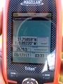
| Sat 17 Sep 2011 in Nogales: 31.7586070, -110.8922134 geohashing.info google osm bing/os kml crox |
Location
Just off the road to Madera Canyon
Participants
Expeditions
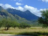
A day hike up Mount Wrightson (4000 ft, 5.5 mi one way) had been planned with friends for over a week. On Friday, I checked the geohash points for the weekend and one of the Saturday ones landed not far off the road through Madera Canyon; the road taken to get to the trailhead. So of course, after hiking 7 hours, I just had to go the "extra mile" (mostly driving) to conquer the tough geohash. I did have to contend with a access-code gate, but fortunately, there were no trespassing restrictions and a nice walk through gate.
It did offer a nice vantage point for a photo of Mt. Wrightson (right of center) where I had been three hours earlier.
Nogales, Arizona
Nogales, Arizona

