Difference between revisions of "2011-09-30 48 7"
From Geohashing
imported>Hijackal (plans) |
imported>FippeBot m (Location) |
||
| (5 intermediate revisions by 2 users not shown) | |||
| Line 28: | Line 28: | ||
== Expedition == | == Expedition == | ||
<!-- how it all turned out. your narrative goes here. --> | <!-- how it all turned out. your narrative goes here. --> | ||
| − | + | The sun was still shining on this last afternoon in September. The two new citizens of Gundelfingen decided to catch this easy available hash near Sexau. It took them only a 15 to 20 minutes bike tour along the fields into a small industrial area. And the hash was just lying on the ground and hid in a gully hole. Fortunately there was not much traffic in the streets... | |
| − | |||
| − | |||
== Photos == | == Photos == | ||
<!-- Insert pictures between the gallery tags using the following format: | <!-- Insert pictures between the gallery tags using the following format: | ||
| − | + | File:2011-09-30 48 7 hash.png | Witty Comment | |
--> | --> | ||
<gallery perrow="5"> | <gallery perrow="5"> | ||
| + | File:2011-09-30 48 7 hash.png | The hash: a hole. | ||
| + | File:2011-09-30 48 7 bikes.png | The means of transportation. [[User:Hijackal]]s bike kept trying to ride away, so we had to take it off the road. Note the hash in the front right. | ||
| + | File:2011-09-30 48 7 smiles.png | The hashers, the hash. Not much traffic here... | ||
</gallery> | </gallery> | ||
| Line 43: | Line 44: | ||
<!-- Add any achievement ribbons you earned below, or remove this section --> | <!-- Add any achievement ribbons you earned below, or remove this section --> | ||
| + | {{Bicycle geohash | latitude = 48 | longitude = 7 | date = 2011-09-30 | name = [[User:Hijackal|Hijackal]] and [[user:Frizzy|Frizzy]] | distance = 10 km }} | ||
| − | |||
| − | |||
| − | |||
| − | + | [[Category:Expeditions with photos]] | |
| − | + | [[Category:Expeditions]] | |
| − | [[Category: | ||
| − | |||
| − | |||
| − | |||
| − | |||
| − | |||
| − | |||
| − | |||
| − | |||
| − | |||
| − | |||
[[Category:Coordinates reached]] | [[Category:Coordinates reached]] | ||
| − | + | {{location|DE|BW|EM}} | |
| − | |||
| − | |||
| − | |||
| − | |||
| − | |||
| − | |||
| − | |||
| − | |||
| − | |||
Latest revision as of 01:03, 13 August 2019
| Fri 30 Sep 2011 in 48,7: 48.0915435, 7.8937278 geohashing.info google osm bing/os kml crox |
Location
In the Upper Rhine Valley, just north of Freiburg. In the middle of a street in a place called Sexau.
Participants
Plans
Bike trip after work, before sunset.
Expedition
The sun was still shining on this last afternoon in September. The two new citizens of Gundelfingen decided to catch this easy available hash near Sexau. It took them only a 15 to 20 minutes bike tour along the fields into a small industrial area. And the hash was just lying on the ground and hid in a gully hole. Fortunately there was not much traffic in the streets...
Photos
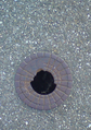
The hash: a hole.
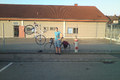
The means of transportation. User:Hijackals bike kept trying to ride away, so we had to take it off the road. Note the hash in the front right.

The hashers, the hash. Not much traffic here...


Achievements
Hijackal and Frizzy earned the Bicycle geohash achievement
|