Difference between revisions of "2011-10-19 55 13"
imported>Fasanen ([live] Mission success!) |
imported>FippeBot m (Location) |
||
| (2 intermediate revisions by one other user not shown) | |||
| Line 1: | Line 1: | ||
| − | |||
| − | |||
| − | |||
| − | |||
| − | |||
| − | |||
| − | |||
| − | |||
| − | |||
| − | |||
{{meetup graticule | {{meetup graticule | ||
| lat=55 | | lat=55 | ||
| Line 15: | Line 5: | ||
}} | }} | ||
| − | |||
__NOTOC__ | __NOTOC__ | ||
== Location == | == Location == | ||
| − | + | Agnesfridsvägen, Malmö. | |
== Participants == | == Participants == | ||
| − | + | [[User:Fasanen|Fasanen]] | |
== Plans == | == Plans == | ||
| − | + | Original plan was not to go. | |
== Expedition == | == Expedition == | ||
| − | + | Today's location was an urban one which is (as far as I have experienced) quite uncommon for this graticule. In order to fit this expedition in today's tight schedule, I left work in Lund about 20 minutes earlier than usual. | |
| + | Pre-planning a route when driving in Malmö is virtually impossible. There is always some unforeseen roadwork going on that requires annoying diversions. No exceptions to this "natural law" today, but fortunately it was before rush-hour so I got to the general geohash area without to much cursing. | ||
| + | |||
| + | The location was in a housing area and the GPS readings were fluttering. The Google maps satellite view was not to any help in determining whether the spot was inside or outside one of the buildings because of its angle. I finally decided it to be in a sloe bush (Prunus spinosa) next to the house wall. | ||
*Mission success! -- [[User:Fasanen|Fasanen]] 15:21, 19 oktober 2011 (CEST) | *Mission success! -- [[User:Fasanen|Fasanen]] 15:21, 19 oktober 2011 (CEST) | ||
| − | |||
| − | |||
== Photos == | == Photos == | ||
| − | < | + | <gallery perrow="4"> |
| − | Image: | + | Image:201110195513 01.JPG |Hash bush in the form of Prunus spinosa |
| − | + | Image:201110195513 02.JPG |View from the geohash | |
| − | + | Image:201110195513 03.JPG |I was surprised to find this phallus a few meters from the geohash. What's its function? | |
| + | Image:201110195513 05.JPG |Me | ||
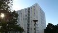
| + | Image:201110195513 06.JPG |Almost like Calatrava's Turning Torso | ||
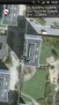
| + | Image:201110195513 07.png |Proof | ||
| + | Image:201110195513 08.png |Inside or outside? | ||
</gallery> | </gallery> | ||
== Achievements == | == Achievements == | ||
{{#vardefine:ribbonwidth|800px}} | {{#vardefine:ribbonwidth|800px}} | ||
| − | + | {{land geohash | latitude=55 | longitude=13 | date=2011-10-19 | name=Fasanen}} | |
| − | |||
| − | |||
| − | |||
| − | |||
| − | |||
| − | |||
| − | |||
| − | |||
| − | |||
| − | |||
| − | |||
[[Category:Expeditions]] | [[Category:Expeditions]] | ||
| − | |||
[[Category:Expeditions with photos]] | [[Category:Expeditions with photos]] | ||
| − | |||
| − | |||
| − | |||
| − | |||
| − | |||
[[Category:Coordinates reached]] | [[Category:Coordinates reached]] | ||
| − | + | [[Category:Sweden]] | |
| − | + | {{location|SE|M}} | |
| − | |||
| − | [[Category: | ||
| − | |||
| − | |||
| − | |||
| − | |||
| − | |||
| − | |||
Latest revision as of 01:18, 13 August 2019
| Wed 19 Oct 2011 in 55,13: 55.5778436, 13.0587934 geohashing.info google osm bing/os kml crox |
Location
Agnesfridsvägen, Malmö.
Participants
Plans
Original plan was not to go.
Expedition
Today's location was an urban one which is (as far as I have experienced) quite uncommon for this graticule. In order to fit this expedition in today's tight schedule, I left work in Lund about 20 minutes earlier than usual.
Pre-planning a route when driving in Malmö is virtually impossible. There is always some unforeseen roadwork going on that requires annoying diversions. No exceptions to this "natural law" today, but fortunately it was before rush-hour so I got to the general geohash area without to much cursing.
The location was in a housing area and the GPS readings were fluttering. The Google maps satellite view was not to any help in determining whether the spot was inside or outside one of the buildings because of its angle. I finally decided it to be in a sloe bush (Prunus spinosa) next to the house wall.
- Mission success! -- Fasanen 15:21, 19 oktober 2011 (CEST)
Photos

Hash bush in the form of Prunus spinosa
View from the geohash
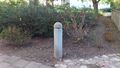
I was surprised to find this phallus a few meters from the geohash. What's its function?

Me

Almost like Calatrava's Turning Torso

Proof
Inside or outside?


Achievements
Fasanen earned the Land geohash achievement
|