Difference between revisions of "2011-10-27 45 -122"
imported>Jiml (Today's herbicide report) |
imported>FippeBot m (Location) |
||
| (4 intermediate revisions by 3 users not shown) | |||
| Line 1: | Line 1: | ||
| − | + | [[Image:{{{image|2011-10-27_45_-122_Overlook_1.jpg}}}|thumb|left]] | |
| − | |||
| − | |||
| − | |||
| − | |||
| − | |||
| − | |||
| − | |||
{{meetup graticule | {{meetup graticule | ||
| lat=45 | | lat=45 | ||
| Line 17: | Line 10: | ||
__NOTOC__ | __NOTOC__ | ||
== Location == | == Location == | ||
| − | + | Sandy Delta park on the East side of Portland along the Columbia | |
== Participants == | == Participants == | ||
| + | |||
* [[User:Jiml|Jim]] | * [[User:Jiml|Jim]] | ||
| − | |||
* [[User:Michael5000|Michael5000]] | * [[User:Michael5000|Michael5000]] | ||
| Line 28: | Line 21: | ||
''M5K'': I've never been to this park, but it seems like it might work for an after-work jogging geohash. With any luck, Jim will provide an accessibility report before I head out! | ''M5K'': I've never been to this park, but it seems like it might work for an after-work jogging geohash. With any luck, Jim will provide an accessibility report before I head out! | ||
| + | |||
== Expedition == | == Expedition == | ||
| + | ===Jim - Part 1 === | ||
M5K is probably already on the way there, but I got pulled up short by a sign at the entry way to the path | M5K is probably already on the way there, but I got pulled up short by a sign at the entry way to the path | ||
in that reported that a large area, including the hashpoint, was being subject to herbicide spraying this | in that reported that a large area, including the hashpoint, was being subject to herbicide spraying this | ||
| Line 36: | Line 31: | ||
So, access didn't look very good. | So, access didn't look very good. | ||
| + | |||
| + | ===M5K=== | ||
| + | Hmm, that's not what I want in my lungs. Expedition abort! | ||
| + | |||
| + | ===Jim - Part 2, the sequel=== | ||
| + | |||
| + | I made a later attempt at the hashpoint, simply because I thought the two mile walk was a reasonable and healthy | ||
| + | thing to do, and because I thought it might be only 20 feet from the trail, which would be "close enough" to | ||
| + | the hashpoint, and far enough from the herbicide. | ||
| + | |||
| + | I got to meet a lot of dogs and owners out on walks, and made it to about 500 feet from the | ||
| + | hashpoint, but didn't want to stray off the trail, especially that far into a sprayed area. | ||
| − | == | + | ===M5K=== |
| − | + | Hmm, that's not what I want in my lungs. Expedition abort! | |
== Photos == | == Photos == | ||
| − | |||
| − | |||
| − | |||
<gallery perrow="5"> | <gallery perrow="5"> | ||
| + | Image:2011-10-27_45_-122_Overlook_1.jpg|View of the Columbia | ||
| + | Image:2011-10-27_45_-122_Overlook_2.jpg|View of the Columbia | ||
| + | Image:2011-10-27_45_-122_Overlook_3.jpg|View of the Columbia | ||
| + | Image:2011-10-27_45_-122_Overlook_4.jpg|View of the Columbia | ||
| + | Image:2011-10-27_45_-122_Warning.jpg|Maybe I don't want to go all the way to the hashpoint | ||
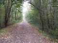
| + | Image:2011-10-27_45_-122_the_path.jpg|Road to the hash zone | ||
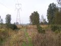
| + | Image:2011-10-27_45_-122_to-Hashpoint.jpg|Off to the hashpoint and herbacide | ||
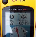
| + | Image:2011-10-27_45_-122_GPS.jpg|The GPS | ||
</gallery> | </gallery> | ||
| + | |||
| + | |||
| + | |||
== Achievements == | == Achievements == | ||
{{#vardefine:ribbonwidth|800px}} | {{#vardefine:ribbonwidth|800px}} | ||
| − | |||
| − | |||
| − | + | * No Trespassing | |
| − | |||
| − | |||
[[Category:Expeditions]] | [[Category:Expeditions]] | ||
| − | |||
[[Category:Expeditions with photos]] | [[Category:Expeditions with photos]] | ||
[[Category:Coordinates not reached]] | [[Category:Coordinates not reached]] | ||
| − | |||
| − | |||
[[Category:Not reached - No public access]] | [[Category:Not reached - No public access]] | ||
| + | {{location|US|OR|MU}} | ||
Latest revision as of 01:21, 13 August 2019

| Thu 27 Oct 2011 in 45,-122: 45.5608230, -122.3770196 geohashing.info google osm bing/os kml crox |
Location
Sandy Delta park on the East side of Portland along the Columbia
Participants
Plans
Jim: I have to go to the airport this morning. I may try to swing by afterwards.
M5K: I've never been to this park, but it seems like it might work for an after-work jogging geohash. With any luck, Jim will provide an accessibility report before I head out!
Expedition
Jim - Part 1
M5K is probably already on the way there, but I got pulled up short by a sign at the entry way to the path in that reported that a large area, including the hashpoint, was being subject to herbicide spraying this week.
So, access didn't look very good.
M5K
Hmm, that's not what I want in my lungs. Expedition abort!
Jim - Part 2, the sequel
I made a later attempt at the hashpoint, simply because I thought the two mile walk was a reasonable and healthy thing to do, and because I thought it might be only 20 feet from the trail, which would be "close enough" to the hashpoint, and far enough from the herbicide.
I got to meet a lot of dogs and owners out on walks, and made it to about 500 feet from the hashpoint, but didn't want to stray off the trail, especially that far into a sprayed area.
M5K
Hmm, that's not what I want in my lungs. Expedition abort!
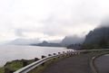
Photos
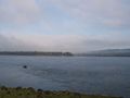
View of the Columbia
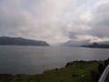
View of the Columbia
View of the Columbia
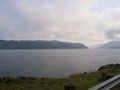
View of the Columbia
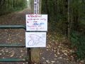
Maybe I don't want to go all the way to the hashpoint
Road to the hash zone
Off to the hashpoint and herbacide
The GPS


Achievements
- No Trespassing