Difference between revisions of "2011-11-05 45 -121"
imported>Kydlt |
imported>FippeBot m (Location) |
||
| (One intermediate revision by one other user not shown) | |||
| Line 13: | Line 13: | ||
== Plans == | == Plans == | ||
| − | No plan, I just ended up there. It got | + | No plan, I just ended up there. It got late in the day and there was no rain, and it was close. |
== Expedition == | == Expedition == | ||
| − | Short drive, vertical hike. Looking at the USGS DOQQ there appeared to be an old road above but it wasn't | + | Short drive, vertical hike. |
| + | |||
| + | Looking at the USGS DOQQ there appeared to be an old road above but it wasn't accessible. | ||
| + | I couldn't park on Wind River Rd below the spot and had to park about 1/2 mi away. | ||
| + | Rather than going in there and trying to catch the logging road | ||
| + | I walked up Wind River Road until I was just below the spot & crosscountried it, 380 vertical feet. | ||
| + | |||
| + | I did this because directly across the rd was a trailhead going down (190 ft) to the river. | ||
| + | A 2fer. | ||
| + | |||
| + | And finding a survey marker on the way up made it a 3fer. | ||
== Tracklog == | == Tracklog == | ||
| Line 28: | Line 38: | ||
Image:2011-11-05 45 -121 04.5 map.JPG | Here is my track overlaying the DOQQ imagery. | Image:2011-11-05 45 -121 04.5 map.JPG | Here is my track overlaying the DOQQ imagery. | ||
Image:2011-11-05 45 -121 05 some trees bear.jpg | T4N. R7E. Sec 25 | Image:2011-11-05 45 -121 05 some trees bear.jpg | T4N. R7E. Sec 25 | ||
| − | Image:2011-11-05 45 -121 06 monument.jpg | I like the | + | Image:2011-11-05 45 -121 06 monument.jpg | I like the monument on a stick. I found no brass disk. |
| − | Image:2011-11-05 45 -121 07 side trip White Salmon Rv..jpg | Just across the road from where I walked up to the hash was a trail going down to Wind River. I | + | Image:2011-11-05 45 -121 07 side trip White Salmon Rv..jpg | Just across the road from where I walked up to the hash was a trail going down to Wind River. (I misnamed the jpg, if you happen to look at the metadata.) |
</gallery> | </gallery> | ||
| + | |||
| + | [[Category:Expeditions]] | ||
| + | [[Category:Expeditions with photos]] | ||
| + | [[Category:Coordinates reached]] | ||
| + | {{location|US|WA|SM}} | ||
Latest revision as of 01:27, 13 August 2019
| Sat 5 Nov 2011 in 45,-121: 45.7960976, -121.8934499 geohashing.info google osm bing/os kml crox |
Location
Off Wind River Rd.
Participants
Plans
No plan, I just ended up there. It got late in the day and there was no rain, and it was close.
Expedition
Short drive, vertical hike.
Looking at the USGS DOQQ there appeared to be an old road above but it wasn't accessible. I couldn't park on Wind River Rd below the spot and had to park about 1/2 mi away. Rather than going in there and trying to catch the logging road I walked up Wind River Road until I was just below the spot & crosscountried it, 380 vertical feet.
I did this because directly across the rd was a trailhead going down (190 ft) to the river. A 2fer.
And finding a survey marker on the way up made it a 3fer.
Tracklog
Photos
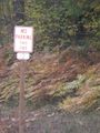
On Wind River Rd, where I wanted to be.
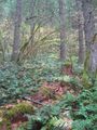
Just climb the hill, old man. And no bitching.
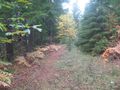
There was a road up here, it just didn't come down.
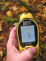
I programmed in the red X, the arc is the GDOP, the 10 ft is the scale.
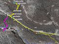
Here is my track overlaying the DOQQ imagery.
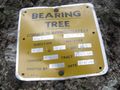
T4N. R7E. Sec 25
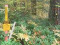
I like the monument on a stick. I found no brass disk.
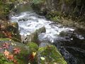
Just across the road from where I walked up to the hash was a trail going down to Wind River. (I misnamed the jpg, if you happen to look at the metadata.)


