Difference between revisions of "2011-12-08 55 13"
From Geohashing
imported>Llavids |
imported>FippeBot m (Location) |
||
| (2 intermediate revisions by one other user not shown) | |||
| Line 16: | Line 16: | ||
== Expedition == | == Expedition == | ||
| − | . | + | Drove out in the morning, fairly close to home. I guessed it could be in a fenced area or a field, but when arriving the fence wasn't there anymore so it was quite easy to walk into the field and take the necessary photos. When returning I found the runestones, which I knew about but didn't know quite where they were. This time they were inaccessible due to a muddy field, so I guess I have to visit them next autumn after harvest instead. |
== Photos == | == Photos == | ||
| − | |||
<gallery perrow="4"> | <gallery perrow="4"> | ||
Image:20111208-55-13-01-Proof.JPG|Proof | Image:20111208-55-13-01-Proof.JPG|Proof | ||
| Line 37: | Line 36: | ||
[[Category:Coordinates reached]] | [[Category:Coordinates reached]] | ||
[[Category:Sweden]] | [[Category:Sweden]] | ||
| + | {{location|SE|M}} | ||
Latest revision as of 01:41, 13 August 2019
| Thu 8 Dec 2011 in 55,13: 55.8795012, 13.1922587 geohashing.info google osm bing/os kml crox |
Location
Östra Karaby, Eslöv, Skåne, Sweden.
Participants
Plans
Drive out and have a look.
Expedition
Drove out in the morning, fairly close to home. I guessed it could be in a fenced area or a field, but when arriving the fence wasn't there anymore so it was quite easy to walk into the field and take the necessary photos. When returning I found the runestones, which I knew about but didn't know quite where they were. This time they were inaccessible due to a muddy field, so I guess I have to visit them next autumn after harvest instead.
Photos

Proof

The grin

North

East

South

West
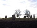
Runestones nearby


Achievements
Llavids earned the Land geohash achievement
|