Difference between revisions of "2012-01-07 53 -1"
imported>Monty (Pre-expedition details.) |
imported>Monty (Completed report (well, apart from the achievements, which I never really complete.)) |
||
| Line 1: | Line 1: | ||
| − | + | [[Image:{{{image|GH20120107 8 ActuallyThere.JPG}}}|thumb|left]] | |
{{meetup graticule | {{meetup graticule | ||
| Line 12: | Line 12: | ||
== Participants == | == Participants == | ||
| − | [[User:Monty|Monty]] plans to be there within an hour. Probably half an hour. He nearly passed it on the way out, and will now definitely be stopping off when he goes home. | + | [[User:Monty|Monty]] plans to be there within an hour. Probably half an hour. He nearly passed it on the way out, and will now definitely be stopping off |
| + | |||
| + | when he goes home. | ||
== Plans == | == Plans == | ||
| − | The hashpoint itself lies just off of a public footpath that leads from the Warren (a hilly, wooded area above Chapeltown) towards Barley Hall and the Wentworth Estate. Since the M1 has cut through the area, the segment of the route from the Warren to the Kirby Lane (Hood Hill to Thorpe Hesley road, Kirby Lane/Barnsley Road) has been diverted to the end of the A6135 road bridge. | + | The hashpoint itself lies just off of a public footpath that leads from the Warren (a hilly, wooded area above Chapeltown) towards Barley Hall and the |
| + | |||
| + | Wentworth Estate. Since the M1 has cut through the area, the segment of the route from the Warren to the Kirby Lane (Hood Hill to Thorpe Hesley road, Kirby | ||
| + | |||
| + | Lane/Barnsley Road) has been diverted to the end of the A6135 road bridge. | ||
| + | |||
| + | Monty will probably park up at the A6135/M1 bridge and walk the dog-leg down to the original path, which is a few yards from what might well be a gate into | ||
| + | |||
| + | the necessary field (signs of use, probably by cattle, in the overheads) and then work out whether it would be a legitimate continuation to pop into the | ||
| − | + | field and across a thin strip of land to the adjacent field boundary where a Hashtree might well be found. | |
The alternate plan is to turn onto Kirby Lane and park up at/approach from the other end of the path segment, but with much the same result. | The alternate plan is to turn onto Kirby Lane and park up at/approach from the other end of the path segment, but with much the same result. | ||
| − | Walking time: five minutes tops. Right, I might as well be off then (after sorting out the Expedition Planning tags, etc), for a driving time of 15-20 minutes from posting, if all goes well. | + | Walking time: five minutes tops. Right, I might as well be off then (after sorting out the Expedition Planning tags, etc), for a driving time of 15-20 |
| + | |||
| + | minutes from posting, if all goes well. | ||
== Expedition == | == Expedition == | ||
| − | + | Horses might have been the theme of the trip. While I've zoomed across this particular bridge over the M1, I don't suppose I'd realised the high number of | |
| − | ... | + | |
| + | horses in the surrounding fields. Within the earshot of the near-continual buzz of motorway traffic, horses graze. Or stand around, as most of them did | ||
| + | |||
| + | while I was there. Clothed (or 'sheeted') against the wind, I'm not sure I would have swapped my existence with them, but insofar as horses look happy, | ||
| + | |||
| + | they tended to be so. Their hooves and quadrapedal motion was certainly far better for the mud I found I had to traipse through. | ||
| + | |||
| + | The footpath starts through a field, along the line of a ribbon-fence. The horses in my section were happy over the other side of the field, one in the | ||
| + | |||
| + | other side kept pace, and seemed happy to be photographed. The grassy field was a bit slippery underfoot, but then there was a proper track. | ||
| + | |||
| + | Ha! Muddier still. I really wasn't kitted out for this expedition. With trainers that were decent ones for walking, but not necessarily for wading | ||
| + | |||
| + | through ankle-deep mud, and light trousers... A tucking of trousers into socks was initiated. Groovy style. | ||
| + | |||
| + | Turning down across the dog-leg, with a lot more mud, but at least some verges (and some more horses to say hello to, over the fences), brought me down into | ||
| + | |||
| + | more or less the valley bottom, the line of the original path. Off to the right there was still a trail, although to what purpose I do not know. To the | ||
| + | |||
| + | left were an open track above the valley-proper (a gate, open, across its entrance) and a full-width gateway down to the shallow bottom. It did not look | ||
| + | |||
| + | like I had expected from the aerial shots. I'm wondering if the higher path has been a recent 'official' replacement for the valley-bottom route. The | ||
| + | |||
| + | route which I need to take. | ||
| + | |||
| + | The top path has a fence along the top of the steepest slope, while down the major gated track is a grassy 'bridge' across the rivulet, and across this is | ||
| + | |||
| + | the target. The fields involved were empty of all livestock or crops (a major stumbling block in some previous expeditions) and the gate to access this | ||
| + | |||
| + | last little walk was not even locked. | ||
| + | |||
| + | That the track down had been concreted over, most of the way, for easier wheeled access was not an advantage given the amount of slippery mud laying over | ||
| + | |||
| + | the hard surface, and so progress was down the grass (squishy, but not too damp). The grass at the bottom and up into the fields was the best walking | ||
| + | |||
| + | conditions encountered since half way across the first field, in fact. | ||
| + | |||
| + | The usual practice of matching trees on the overheads to the trees on the ground made it apparent that a multi-stemmed tree was the one that lay underneath | ||
| + | |||
| + | the aerial photo's pointer. Tripod planted and camera attached at a point that gave a good all-encompassing view, the Grin shot now needed to be | ||
| + | |||
| + | accomplished. Having done this a good few times, I should really know how far I can travel over various types of terrain in ten seconds, but looking back | ||
| + | |||
| + | to see how the flashing on the camera is going doesn't help. Anyway, with a suitable 'nearly there' shot made, a more zoom was applied, and the ten-second | ||
| + | |||
| + | dash was accomplished without further hesitation. (Yes, I could have moved the camera closer to the tree, but where would be the sport in that? :) ) | ||
| + | |||
| + | The return was just as muddy, and one aspect of the trip not so far mentioned was the wind. Never learning to use the chinstrap, I again managed to have my | ||
| + | |||
| + | hat blown off, something that I had been fighting against for almost all of the walk so far. Also, with ground and air conditions, it had taken more than | ||
| + | |||
| + | the five or ten minutes to accomplish than I had originally anticipated. | ||
| + | |||
| + | And so, home. Except not home, as I popped into work, as the easiest place to make this report from. Now, if someone can tell me why I get 'still loading | ||
| + | |||
| + | page...' browser errors/delays on this wiki site, slowing down the whole process, I'd very much like to hear something of it. Still, I had other things to | ||
| + | |||
| + | do while busy disconnecting and reconnecting and rebooting the machine and re-opening the browser. Indeed, using two different browsers on each of two | ||
| + | |||
| + | machines. Now, let's see if this posts. If it does, I ''can'' go home with a clear conscience (having decided to get this year's geohash reports up in a | ||
| + | |||
| + | timely fashion, the "windy windy, still loading" issue having prevented most of my good intentions with last year's, and still an awfully large backlog to | ||
| + | |||
| + | get through...). Good night, all. | ||
== Tracklog == | == Tracklog == | ||
| − | + | No GPS available. | |
| − | No GPS | ||
== Photos == | == Photos == | ||
| − | |||
| − | |||
| − | |||
<gallery perrow="5"> | <gallery perrow="5"> | ||
| + | Image:GH20120107 1 BoundaryBridge.JPG | Here I start | ||
| + | Image:GH20120107 2 Footpath.JPG | Across the field | ||
| + | Image:GH20120107 3 AHorseOfCourse.JPG | A local resident | ||
| + | Image:GH20120107 4 ThatTintinLook.JPG | Could be drier | ||
| + | Image:GH20120107 5 PartingOfTheWays.JPG | Down here | ||
| + | Image:GH20120107 6 Track.JPG | Nearly there | ||
| + | Image:GH20120107 7 NotQuiteThere.JPG | Ten second dash | ||
| + | Image:GH20120107 8 ActuallyThere.JPG | And here we are | ||
</gallery> | </gallery> | ||
| − | |||
== Achievements == | == Achievements == | ||
| Line 44: | Line 122: | ||
Probably: Land, No batteries. | Probably: Land, No batteries. | ||
| − | + | [[Category:Expeditions]] | |
| − | + | [[Category:Expeditions with photos]] | |
| − | + | [[Category:Expedition without GPS]] | |
| − | + | [[Category:Coordinates reached]] | |
| − | |||
| − | |||
| − | |||
| − | |||
| − | |||
| − | |||
| − | |||
| − | |||
| − | |||
| − | |||
| − | |||
| − | |||
| − | |||
| − | |||
| − | |||
| − | |||
| − | |||
| − | |||
Revision as of 01:29, 8 January 2012

| Sat 7 Jan 2012 in 53,-1: 53.4703656, -1.4493502 geohashing.info google osm bing/os kml crox |
Location
Nr. Hood Hill Farm, Hood Hill, Wentworth, ?Barnsley? (Very close to Sheffield, but I think it's still technically in Barnsley.)
Participants
Monty plans to be there within an hour. Probably half an hour. He nearly passed it on the way out, and will now definitely be stopping off
when he goes home.
Plans
The hashpoint itself lies just off of a public footpath that leads from the Warren (a hilly, wooded area above Chapeltown) towards Barley Hall and the
Wentworth Estate. Since the M1 has cut through the area, the segment of the route from the Warren to the Kirby Lane (Hood Hill to Thorpe Hesley road, Kirby
Lane/Barnsley Road) has been diverted to the end of the A6135 road bridge.
Monty will probably park up at the A6135/M1 bridge and walk the dog-leg down to the original path, which is a few yards from what might well be a gate into
the necessary field (signs of use, probably by cattle, in the overheads) and then work out whether it would be a legitimate continuation to pop into the
field and across a thin strip of land to the adjacent field boundary where a Hashtree might well be found.
The alternate plan is to turn onto Kirby Lane and park up at/approach from the other end of the path segment, but with much the same result.
Walking time: five minutes tops. Right, I might as well be off then (after sorting out the Expedition Planning tags, etc), for a driving time of 15-20
minutes from posting, if all goes well.
Expedition
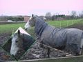
Horses might have been the theme of the trip. While I've zoomed across this particular bridge over the M1, I don't suppose I'd realised the high number of
horses in the surrounding fields. Within the earshot of the near-continual buzz of motorway traffic, horses graze. Or stand around, as most of them did
while I was there. Clothed (or 'sheeted') against the wind, I'm not sure I would have swapped my existence with them, but insofar as horses look happy,
they tended to be so. Their hooves and quadrapedal motion was certainly far better for the mud I found I had to traipse through.
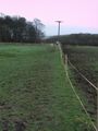
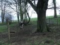
The footpath starts through a field, along the line of a ribbon-fence. The horses in my section were happy over the other side of the field, one in the
other side kept pace, and seemed happy to be photographed. The grassy field was a bit slippery underfoot, but then there was a proper track.
Ha! Muddier still. I really wasn't kitted out for this expedition. With trainers that were decent ones for walking, but not necessarily for wading
through ankle-deep mud, and light trousers... A tucking of trousers into socks was initiated. Groovy style.
Turning down across the dog-leg, with a lot more mud, but at least some verges (and some more horses to say hello to, over the fences), brought me down into
more or less the valley bottom, the line of the original path. Off to the right there was still a trail, although to what purpose I do not know. To the
left were an open track above the valley-proper (a gate, open, across its entrance) and a full-width gateway down to the shallow bottom. It did not look
like I had expected from the aerial shots. I'm wondering if the higher path has been a recent 'official' replacement for the valley-bottom route. The
route which I need to take.
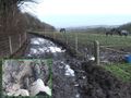
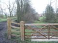
The top path has a fence along the top of the steepest slope, while down the major gated track is a grassy 'bridge' across the rivulet, and across this is
the target. The fields involved were empty of all livestock or crops (a major stumbling block in some previous expeditions) and the gate to access this
last little walk was not even locked.
That the track down had been concreted over, most of the way, for easier wheeled access was not an advantage given the amount of slippery mud laying over
the hard surface, and so progress was down the grass (squishy, but not too damp). The grass at the bottom and up into the fields was the best walking
conditions encountered since half way across the first field, in fact.
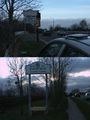
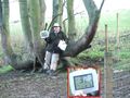
The usual practice of matching trees on the overheads to the trees on the ground made it apparent that a multi-stemmed tree was the one that lay underneath
the aerial photo's pointer. Tripod planted and camera attached at a point that gave a good all-encompassing view, the Grin shot now needed to be
accomplished. Having done this a good few times, I should really know how far I can travel over various types of terrain in ten seconds, but looking back
to see how the flashing on the camera is going doesn't help. Anyway, with a suitable 'nearly there' shot made, a more zoom was applied, and the ten-second
dash was accomplished without further hesitation. (Yes, I could have moved the camera closer to the tree, but where would be the sport in that? :) )
The return was just as muddy, and one aspect of the trip not so far mentioned was the wind. Never learning to use the chinstrap, I again managed to have my
hat blown off, something that I had been fighting against for almost all of the walk so far. Also, with ground and air conditions, it had taken more than
the five or ten minutes to accomplish than I had originally anticipated.
And so, home. Except not home, as I popped into work, as the easiest place to make this report from. Now, if someone can tell me why I get 'still loading
page...' browser errors/delays on this wiki site, slowing down the whole process, I'd very much like to hear something of it. Still, I had other things to
do while busy disconnecting and reconnecting and rebooting the machine and re-opening the browser. Indeed, using two different browsers on each of two
machines. Now, let's see if this posts. If it does, I can go home with a clear conscience (having decided to get this year's geohash reports up in a
timely fashion, the "windy windy, still loading" issue having prevented most of my good intentions with last year's, and still an awfully large backlog to
get through...). Good night, all.
Tracklog
No GPS available.
Photos
Here I start
Across the field
A local resident
Could be drier
Down here
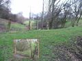
Nearly there
Ten second dash
And here we are


Achievements
Probably: Land, No batteries.