Difference between revisions of "2012-01-26 44 -117"
From Geohashing
imported>Kydlt (→Plans) |
imported>FippeBot m (Location) |
||
| Line 38: | Line 38: | ||
[[Category:Expeditions with photos]] | [[Category:Expeditions with photos]] | ||
[[Category:Coordinates reached]] | [[Category:Coordinates reached]] | ||
| + | {{location|US|OR|BA}} | ||
Revision as of 02:12, 13 August 2019
| Thu 26 Jan 2012 in 44,-117: 44.7985385, -117.8281663 geohashing.info google osm bing/os kml crox |
Location
Out of Baker City, OR
Participants
Plans
Driving to see friends in Idaho, about 8 hours all the way across Oregon. This took me across many graticles, but only had time to visit this one.
Expedition
Before we left I checked for hashes, and had 3 or 4 possible ones, but this looked about the best given time constraints. And it was virgin territory. At first i thought it was behind a no trespassing sign, but then decided that the sign was for an ajacent farm. There was a creek to cross, but it had a beam to walk. A jog across the mud, out into the stubble of last years crop, & take a photo of the GPS.
Photos
In Baker City, Oregon, About 2 mi off I-84.
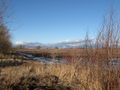
In a field, about 500 ft out. Thru the thawing mud.
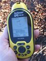
The trusty delorme. It has too many numbers.


