Difference between revisions of "2012-02-04 38 -77"
From Geohashing
imported>SDGathman (Created page with "Part of Manassas battlefield park, just across a creek from a handy park road. Park open to the public until dark. I could go again if anyone wants to go on Sunday.") |
imported>FippeBot m (Location) |
||
| (10 intermediate revisions by 2 users not shown) | |||
| Line 1: | Line 1: | ||
| − | Part of Manassas battlefield park, just across a creek from a handy park road. | + | <!-- If you did not specify these parameters in the template, please substitute appropriate values for IMAGE, LAT, LON, and DATE (YYYY-MM-DD format) |
| + | |||
| + | [[Image:{{{image|IMAGE}}}|thumb|left]] | ||
| + | |||
| + | Remove this section if you don't want an image at the top (left) of your report. You should remove the "Image:" or "File:" | ||
| + | tag from your image file name, and replace the all upper-case word IMAGE in the above line. | ||
| + | |||
| + | And DON'T FORGET to add your expedition and the best photo you took to the gallery on the Main Page! We'd love to read your report, but that means we first have to discover it! | ||
| + | --> | ||
| + | {{meetup graticule | ||
| + | | lat=38 | ||
| + | | lon=-77 | ||
| + | | date=2012-02-04 | ||
| + | }} | ||
| + | |||
| + | |||
| + | __NOTOC__ | ||
| + | == Location == | ||
| + | |||
| + | Part of Manassas battlefield park, just across a creek from a handy park road. | ||
| + | |||
| + | Park open to the public until dark. I could go again if anyone wants to go on Sunday. I forgot my camera, and had to use my cell phone. | ||
| + | |||
| + | == Participants == | ||
| + | |||
| + | [[User:SDGathman|Stuart Gathman]] | ||
| + | |||
| + | == Plans == | ||
| + | <!-- what were the original plans --> | ||
| + | |||
| + | == Expedition == | ||
| + | <!-- how it all turned out. your narrative goes here. --> | ||
| + | |||
| + | Unknown. Appears that someone went per the location comments. | ||
| + | |||
| + | == Tracklog == | ||
| + | |||
| + | http://www.openstreetmap.org/user/SDGathman/traces/1176133 | ||
| + | |||
| + | == Photos == | ||
| + | |||
| + | <gallery perrow="5"> | ||
| + | Image:P02-04-12_16.58.jpg|The meetup location on a wooded hillside | ||
| + | Image:P02-04-12_17.05.jpg|Across a creek from the park road. | ||
| + | </gallery> | ||
| + | |||
| + | == Achievements == | ||
| + | {{#vardefine:ribbonwidth|800px}} | ||
| + | <!-- Add any achievement ribbons you earned below, or remove this section --> | ||
| + | |||
| + | * Land geohash? | ||
| + | |||
| + | |||
| + | |||
| + | [[Category:Expeditions]] | ||
| + | |||
| + | [[Category:Expeditions with photos]] | ||
| + | [[Category:Coordinates reached]] | ||
| + | {{location|US|VA|PW}} | ||
Latest revision as of 02:17, 13 August 2019
| Sat 4 Feb 2012 in 38,-77: 38.8079377, -77.5303929 geohashing.info google osm bing/os kml crox |
Location
Part of Manassas battlefield park, just across a creek from a handy park road.
Park open to the public until dark. I could go again if anyone wants to go on Sunday. I forgot my camera, and had to use my cell phone.
Participants
Plans
Expedition
Unknown. Appears that someone went per the location comments.
Tracklog
http://www.openstreetmap.org/user/SDGathman/traces/1176133
Photos
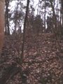
The meetup location on a wooded hillside
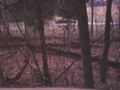
Across a creek from the park road.


Achievements
- Land geohash?