Difference between revisions of "2012-02-04 38 -77"
From Geohashing
imported>SDGathman |
imported>FippeBot m (Location) |
||
| (6 intermediate revisions by 2 users not shown) | |||
| Line 14: | Line 14: | ||
}} | }} | ||
| − | + | ||
__NOTOC__ | __NOTOC__ | ||
== Location == | == Location == | ||
| − | + | ||
| + | Part of Manassas battlefield park, just across a creek from a handy park road. | ||
| + | |||
| + | Park open to the public until dark. I could go again if anyone wants to go on Sunday. I forgot my camera, and had to use my cell phone. | ||
== Participants == | == Participants == | ||
| − | + | ||
| + | [[User:SDGathman|Stuart Gathman]] | ||
== Plans == | == Plans == | ||
| Line 27: | Line 31: | ||
== Expedition == | == Expedition == | ||
<!-- how it all turned out. your narrative goes here. --> | <!-- how it all turned out. your narrative goes here. --> | ||
| + | |||
| + | Unknown. Appears that someone went per the location comments. | ||
== Tracklog == | == Tracklog == | ||
| − | + | ||
| + | http://www.openstreetmap.org/user/SDGathman/traces/1176133 | ||
== Photos == | == Photos == | ||
| − | + | ||
| − | |||
| − | |||
<gallery perrow="5"> | <gallery perrow="5"> | ||
| + | Image:P02-04-12_16.58.jpg|The meetup location on a wooded hillside | ||
| + | Image:P02-04-12_17.05.jpg|Across a creek from the park road. | ||
</gallery> | </gallery> | ||
| Line 42: | Line 49: | ||
<!-- Add any achievement ribbons you earned below, or remove this section --> | <!-- Add any achievement ribbons you earned below, or remove this section --> | ||
| + | * Land geohash? | ||
| − | |||
| − | |||
| − | |||
| − | |||
| − | |||
| − | |||
| − | |||
| − | |||
[[Category:Expeditions]] | [[Category:Expeditions]] | ||
| − | + | ||
[[Category:Expeditions with photos]] | [[Category:Expeditions with photos]] | ||
| − | |||
| − | |||
| − | |||
| − | |||
| − | |||
[[Category:Coordinates reached]] | [[Category:Coordinates reached]] | ||
| − | + | {{location|US|VA|PW}} | |
| − | |||
| − | |||
| − | |||
| − | |||
| − | |||
| − | |||
| − | |||
| − | |||
| − | |||
Latest revision as of 02:17, 13 August 2019
| Sat 4 Feb 2012 in 38,-77: 38.8079377, -77.5303929 geohashing.info google osm bing/os kml crox |
Location
Part of Manassas battlefield park, just across a creek from a handy park road.
Park open to the public until dark. I could go again if anyone wants to go on Sunday. I forgot my camera, and had to use my cell phone.
Participants
Plans
Expedition
Unknown. Appears that someone went per the location comments.
Tracklog
http://www.openstreetmap.org/user/SDGathman/traces/1176133
Photos
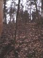
The meetup location on a wooded hillside

Across a creek from the park road.


Achievements
- Land geohash?