Difference between revisions of "2012-02-20 50 4"
From Geohashing
imported>Tyros (→Participants) |
imported>FippeBot m (Location) |
||
| (11 intermediate revisions by 2 users not shown) | |||
| Line 1: | Line 1: | ||
| − | |||
| − | |||
| − | |||
| − | |||
| − | |||
| − | |||
| − | |||
| − | |||
| − | |||
| − | |||
{{meetup graticule | {{meetup graticule | ||
| lat=50 | | lat=50 | ||
| Line 19: | Line 9: | ||
== Location == | == Location == | ||
<!-- where you've surveyed the hash to be --> | <!-- where you've surveyed the hash to be --> | ||
| + | In an open field between Charleroi & Namur. | ||
== Participants == | == Participants == | ||
<!-- who attended --> | <!-- who attended --> | ||
| − | [[User:Tyros]] | + | [[User:Tyros|Tyros]] |
== Plans == | == Plans == | ||
| Line 28: | Line 19: | ||
== Expedition == | == Expedition == | ||
| − | + | This is my first expedition. I parked the car about 300m from the location. The soil was very muddy because the melting water could not penetrate the frozen layer beneath. The weather and the view were magnificent. | |
| + | I had a lot of trouble making this log. But then I realized that there's an Android app that van do it for you. Some info is missing and needs to be edited manually. | ||
== Tracklog == | == Tracklog == | ||
| Line 38: | Line 30: | ||
--> | --> | ||
<gallery perrow="5"> | <gallery perrow="5"> | ||
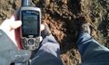
| − | + | Image:2012-02-20_50_4_19-55-44-776.jpg | The evidence. The image was uploaded from my home. | |
| − | Image:2012-02-20_50_4_19-55-44-776.jpg | | + | Image:2012 02 20 50 4 mud.jpg | Looking down |
| + | Image:2012 02 20 50 4 view1.jpg | ||
| + | Image:2012 02 20 50 4 view2.jpg | ||
| + | Image:2012 02 20 50 4 another view.jpg | ||
</gallery> | </gallery> | ||
| Line 46: | Line 41: | ||
<!-- Add any achievement ribbons you earned below, or remove this section --> | <!-- Add any achievement ribbons you earned below, or remove this section --> | ||
| − | |||
| − | |||
| − | |||
| − | |||
| − | |||
| − | |||
| − | |||
| − | |||
| − | |||
| − | |||
| − | |||
[[Category:Expeditions]] | [[Category:Expeditions]] | ||
| − | |||
[[Category:Expeditions with photos]] | [[Category:Expeditions with photos]] | ||
| − | |||
| − | |||
| − | |||
| − | |||
| − | |||
[[Category:Coordinates reached]] | [[Category:Coordinates reached]] | ||
| − | + | {{location|BE|WNA}} | |
| − | |||
| − | |||
| − | |||
| − | |||
| − | |||
| − | |||
| − | |||
| − | |||
| − | |||
Latest revision as of 04:30, 6 August 2019
| Mon 20 Feb 2012 in 50,4: 50.4981044, 4.6267383 geohashing.info google osm bing/os kml crox |
Location
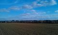
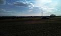
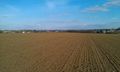
In an open field between Charleroi & Namur.
Participants
Plans
Expedition
This is my first expedition. I parked the car about 300m from the location. The soil was very muddy because the melting water could not penetrate the frozen layer beneath. The weather and the view were magnificent. I had a lot of trouble making this log. But then I realized that there's an Android app that van do it for you. Some info is missing and needs to be edited manually.
Tracklog
Photos
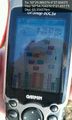
The evidence. The image was uploaded from my home.
Looking down