Difference between revisions of "2012-02-22 59 18"
imported>Cjk ([live picture] Not the easiest way back) |
imported>FippeBot m (Location) |
||
| (10 intermediate revisions by one other user not shown) | |||
| Line 1: | Line 1: | ||
| − | + | [[Image:{{{image|2012-02-22_59_18_15-19-54-089.jpg}}}|thumb|left]] | |
| − | |||
| − | [[Image:{{{image| | ||
| − | |||
| − | |||
| − | |||
| − | |||
| − | |||
| − | |||
{{meetup graticule | {{meetup graticule | ||
| lat=59 | | lat=59 | ||
| Line 19: | Line 11: | ||
<!-- where you've surveyed the hash to be --> | <!-- where you've surveyed the hash to be --> | ||
Looks like 500 m into the woods off 259 near "Handen". | Looks like 500 m into the woods off 259 near "Handen". | ||
| + | |||
| + | == Video == | ||
| + | The short snippet of a wild boar running away. "Big Foot" quality on the footage but as wild boars sometimes tries to chicken race you and ram you to the ground to show who's boss, I was glad that he ran away. | ||
| + | |||
| + | [http://www.youtube.com/watch?v=oPCs7PCD3s4 Video] | ||
== Participants == | == Participants == | ||
| Line 26: | Line 23: | ||
== Plans == | == Plans == | ||
<!-- what were the original plans --> | <!-- what were the original plans --> | ||
| − | I need to go to Webhallen in Fruängen and pick up some stuff for work so I'm planning to swing by after that. | + | I need to go to Webhallen in Fruängen and pick up some stuff for work so I'm planning to swing by after that. I also planned very carefully so I could get a TRON achievement by selecting onramps that didn't cross themselves. |
== Expedition == | == Expedition == | ||
<!-- how it all turned out. your narrative goes here. --> | <!-- how it all turned out. your narrative goes here. --> | ||
| + | *Hiking in the woods looks nice today. -- [[User:Cjk|Carl-Johan]] 12:36, 22 February 2012 (CET) | ||
| + | |||
| + | Took off from Courtyard Mariott to Webhallen in Fruängen. Got the stuff I needed while the GPS/phone stayed in the car. And to continue on my TRON I took a right instead of going back to continue on on Elsa Brändströms gata. Some traffic on the way towards the 259 but nothing major. Got off at the right exit and I had little over 1 km left to the hash.I parked the car in such a way that I could exit on one side and enter through the other in order to not mess up the TRON. | ||
| + | |||
| + | Walked south on the road next to some fields and the plan was to get to the exact latitude and then go east and traverse the hash and then not take the road back but walk in the fields. As I got closer I realized that it was very hilly and some part were not climbable so I would have to plan carefully so I wouldn't invalidate TRON. | ||
| + | |||
| + | [[Image:2012-02-22_59_18_18-40-03-869.jpg| 200px]] | ||
| + | |||
| + | Found a good entry point into the woods. 591 m to go. As I got ready to scale the hill I saw a nice orienteering marker just on the foot of the hill. I also saw some footprints, and I would later see more of these made by the same person, made over the course of several days I figured. More on that later. I climbed the hill and took off almost due east, got to a small down hill section towards a lighter straight section on google maps which I had figured was some power lines, and this turned out to be the case. | ||
| + | |||
| + | [[Image:2012-02-22_59_18_18-41-53-432.jpg|200px]] | ||
| + | |||
| + | I followed these southeast so I could traverse the hash from south to north and not cross my path. Got closer and closer and climbed two more smaller hills. All of a sudden I only had 16 m left and I was just south of the hash. Got to the hash and took some pics. | ||
| + | |||
| + | *Made it -- [[User:Cjk|Carl-Johan]] [http://www.openstreetmap.org/?lat=59.16414244&lon=18.08374814&zoom=16&layers=B000FTF @59.1641,18.0837] 15:16, 22 February 2012 (CET) | ||
| + | |||
| + | [[Image:2012-02-22_59_18_15-20-49-947.jpg|800px]] | ||
| + | |||
| + | Continued walking north and marked the hash with Orange™ and snapped some more pics before heading west making sure I stayed away from my old tracks. As I got closer to the power lines I saw another two moose beds, as saw for the first time in a previous hash. This was actually the first time I had seen moose tracks, I had only seen smaller animals tracks before. I got closer and closer to the power lines and I made sure I was far enough north not to cross my own tracks. | ||
| + | |||
| + | [[http://www.youtube.com/watch?v=oPCs7PCD3s4 A noise behind me]] | ||
| + | |||
| + | All of a sudden I hear something behind me. I figure it is a hunter or something. But it's not. Beyond a small bump between the trees about 20 m away from me I see something dark and two eyes looking back at me. I duck down, get the phone into Video mode and start shooting, inching my way towards the animal. It might be a young moose I think. Lets hope it doesn't attack. All of a sudden the animal gets startled and runs away to the north, and I instantly see that it was no moose, it was a wild boar! They can be very territorial and test you by running chicken race right towards you. I'm quite excited anyway. | ||
| + | *I just caught a wild boar on video!!! -- [[User:Cjk|Carl-Johan]] [http://www.openstreetmap.org/?lat=59.16446066&lon=18.07765064&zoom=16&layers=B000FTF @59.1645,18.0777] 15:37, 22 February 2012 (CET) | ||
| − | + | I get out to the power lines and follow them northwest and I see lots of footprints from the same guy I have seen before. Going in lots of different directions, and different amounts of decay to the tracks so he's been walking here a lot the last weeks. At least 3 different sets of tracks. I follow his tracks cause he might be walking home and knows a good route. I get to the steep down hill section, this time a bit north of where I walked up and I see a stable and a girl fixing with some horses. A go down and cross their yard and stay away from the road. Get to the back side of the houses I've seen before and they have at least three dogs that I can see. They bark at me. One is a German Sheppard. I make my way behind their grounds to the field next to the road and stay off the road all the way to the car and enter from the other side. The GPS got confused a bit and lost some satellite but I claim TRON anyway. | |
| − | + | Get rolling in the car and take a route I've selected home that doesn't cross itself or my previous route and park in exactly the same spot that I started from. Or 10 m away from it according to MyTracks. Mumble, mumble, GPS accuracy, mumble.... | |
| − | |||
== Tracklog == | == Tracklog == | ||
<!-- if your GPS device keeps a log, you may post a link here --> | <!-- if your GPS device keeps a log, you may post a link here --> | ||
| + | [http://maps.google.com/maps/ms?msa=0&msid=209560846421673743077.0004b98f568feb50e60a8 Map] | ||
== Photos == | == Photos == | ||
| Line 45: | Line 66: | ||
--> | --> | ||
<gallery perrow="5"> | <gallery perrow="5"> | ||
| + | |||
| + | Image:2012-02-22_59_18_18-38-45-574.jpg | Cops fining someone | ||
Image:2012-02-22_59_18_14-33-59-111.jpg | Welcome to Paradise! [http://www.openstreetmap.org/?lat=59.17130000&lon=18.06820000&zoom=16&layers=B000FTF @59.1713,18.0682] | Image:2012-02-22_59_18_14-33-59-111.jpg | Welcome to Paradise! [http://www.openstreetmap.org/?lat=59.17130000&lon=18.06820000&zoom=16&layers=B000FTF @59.1713,18.0682] | ||
| − | |||
| − | |||
| − | |||
| − | |||
| − | |||
| − | |||
| − | |||
| − | |||
Image:2012-02-22_59_18_18-39-06-419.jpg | Houses | Image:2012-02-22_59_18_18-39-06-419.jpg | Houses | ||
| Line 67: | Line 82: | ||
Image:2012-02-22_59_18_18-41-53-432.jpg | Powerlines | Image:2012-02-22_59_18_18-41-53-432.jpg | Powerlines | ||
| + | |||
| + | Image:2012-02-22_59_18_15-19-54-089.jpg | No moose around [http://www.openstreetmap.org/?lat=59.16410000&lon=18.08370000&zoom=16&layers=B000FTF @59.1641,18.0837] | ||
| + | |||
| + | Image:2012-02-22_59_18_15-20-24-075.jpg | Panorama 1 [http://www.openstreetmap.org/?lat=59.16414734&lon=18.08375736&zoom=16&layers=B000FTF @59.1641,18.0838] | ||
| + | |||
| + | Image:2012-02-22_59_18_15-20-49-947.jpg | Panorama 2 [http://www.openstreetmap.org/?lat=59.16414734&lon=18.08375736&zoom=16&layers=B000FTF @59.1641,18.0838] | ||
Image:2012-02-22_59_18_18-42-13-937.jpg | Marker | Image:2012-02-22_59_18_18-42-13-937.jpg | Marker | ||
| − | Image:2012-02-22_59_18_18-42-39-836.jpg | | + | Image:2012-02-22_59_18_18-42-39-836.jpg | Orange™ marks the spot |
Image:2012-02-22_59_18_18-43-04-786.jpg | Moose bed | Image:2012-02-22_59_18_18-43-04-786.jpg | Moose bed | ||
Image:2012-02-22_59_18_18-44-02-010.jpg | Not the easiest way back | Image:2012-02-22_59_18_18-44-02-010.jpg | Not the easiest way back | ||
| + | |||
| + | Image:2012-02-22_59_18_18-44-38-309.jpg | Back at the powerlines | ||
| + | |||
| + | Image:2012-02-22_59_18_18-44-59-167.jpg | Stable | ||
| + | |||
| + | Image:2012-02-22_59_18_18-45-34-992.jpg | Abandoned water heater | ||
| + | |||
| + | Image:2012-02-22_59_18_18-45-53-732.jpg | Playhouse | ||
| + | |||
| + | Image:2012-02-22_59_18_18-46-13-732.jpg | Hey doggy | ||
| + | |||
| + | Image:2012-02-22_59_18_18-47-11-066.jpg | Those are my tracks, not what the GPS said! | ||
</gallery> | </gallery> | ||
| Line 80: | Line 113: | ||
{{#vardefine:ribbonwidth|800px}} | {{#vardefine:ribbonwidth|800px}} | ||
<!-- Add any achievement ribbons you earned below, or remove this section --> | <!-- Add any achievement ribbons you earned below, or remove this section --> | ||
| + | {{land geohash | latitude = 59 | longitude = 18 | date = 2012-02-22 | name = [[User:Cjk|Carl-Johan]]}} | ||
| + | {{Tron | latitude = 59 | longitude = 18 | date = 2012-02-22 | name = [[User:Cjk|Carl-Johan]] | possessive = his | tracklog = http://maps.google.com/maps/ms?msa=0&msid=209560846421673743077.0004b98f568feb50e60a8 }} | ||
| + | {{police geohash | latitude = 59 | longitude = 18 | date = 2012-02-22 | name = [[User:Cjk|Carl-Johan]]}} | ||
<!-- =============== USEFUL CATEGORIES FOLLOW ================ | <!-- =============== USEFUL CATEGORIES FOLLOW ================ | ||
Delete the next line ONLY if you have chosen the appropriate categories below. If you are unsure, don't worry. People will read your report and help you with the classification. --> | Delete the next line ONLY if you have chosen the appropriate categories below. If you are unsure, don't worry. People will read your report and help you with the classification. --> | ||
| − | |||
| − | |||
| − | |||
| − | |||
| − | |||
| − | |||
| − | |||
| − | |||
| − | |||
[[Category:Expeditions]] | [[Category:Expeditions]] | ||
| − | |||
[[Category:Expeditions with photos]] | [[Category:Expeditions with photos]] | ||
[[Category:Expeditions with videos]] | [[Category:Expeditions with videos]] | ||
| − | |||
| − | |||
| − | |||
| − | |||
[[Category:Coordinates reached]] | [[Category:Coordinates reached]] | ||
| − | + | {{location|SE|AB}} | |
| − | |||
| − | |||
| − | |||
| − | |||
| − | |||
| − | |||
| − | |||
| − | |||
| − | |||
Latest revision as of 02:29, 13 August 2019

| Wed 22 Feb 2012 in 59,18: 59.1641560, 18.0837553 geohashing.info google osm bing/os kml crox |
Location
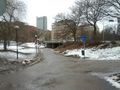
Looks like 500 m into the woods off 259 near "Handen".
Video
The short snippet of a wild boar running away. "Big Foot" quality on the footage but as wild boars sometimes tries to chicken race you and ram you to the ground to show who's boss, I was glad that he ran away.
Participants
Plans
I need to go to Webhallen in Fruängen and pick up some stuff for work so I'm planning to swing by after that. I also planned very carefully so I could get a TRON achievement by selecting onramps that didn't cross themselves.
Expedition
- Hiking in the woods looks nice today. -- Carl-Johan 12:36, 22 February 2012 (CET)
Took off from Courtyard Mariott to Webhallen in Fruängen. Got the stuff I needed while the GPS/phone stayed in the car. And to continue on my TRON I took a right instead of going back to continue on on Elsa Brändströms gata. Some traffic on the way towards the 259 but nothing major. Got off at the right exit and I had little over 1 km left to the hash.I parked the car in such a way that I could exit on one side and enter through the other in order to not mess up the TRON.
Walked south on the road next to some fields and the plan was to get to the exact latitude and then go east and traverse the hash and then not take the road back but walk in the fields. As I got closer I realized that it was very hilly and some part were not climbable so I would have to plan carefully so I wouldn't invalidate TRON.

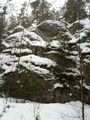
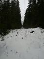
Found a good entry point into the woods. 591 m to go. As I got ready to scale the hill I saw a nice orienteering marker just on the foot of the hill. I also saw some footprints, and I would later see more of these made by the same person, made over the course of several days I figured. More on that later. I climbed the hill and took off almost due east, got to a small down hill section towards a lighter straight section on google maps which I had figured was some power lines, and this turned out to be the case.

I followed these southeast so I could traverse the hash from south to north and not cross my path. Got closer and closer and climbed two more smaller hills. All of a sudden I only had 16 m left and I was just south of the hash. Got to the hash and took some pics.
- Made it -- Carl-Johan @59.1641,18.0837 15:16, 22 February 2012 (CET)

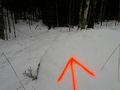
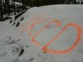
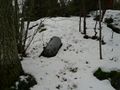
Continued walking north and marked the hash with Orange™ and snapped some more pics before heading west making sure I stayed away from my old tracks. As I got closer to the power lines I saw another two moose beds, as saw for the first time in a previous hash. This was actually the first time I had seen moose tracks, I had only seen smaller animals tracks before. I got closer and closer to the power lines and I made sure I was far enough north not to cross my own tracks.
All of a sudden I hear something behind me. I figure it is a hunter or something. But it's not. Beyond a small bump between the trees about 20 m away from me I see something dark and two eyes looking back at me. I duck down, get the phone into Video mode and start shooting, inching my way towards the animal. It might be a young moose I think. Lets hope it doesn't attack. All of a sudden the animal gets startled and runs away to the north, and I instantly see that it was no moose, it was a wild boar! They can be very territorial and test you by running chicken race right towards you. I'm quite excited anyway.
- I just caught a wild boar on video!!! -- Carl-Johan @59.1645,18.0777 15:37, 22 February 2012 (CET)
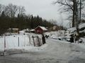
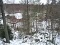
I get out to the power lines and follow them northwest and I see lots of footprints from the same guy I have seen before. Going in lots of different directions, and different amounts of decay to the tracks so he's been walking here a lot the last weeks. At least 3 different sets of tracks. I follow his tracks cause he might be walking home and knows a good route. I get to the steep down hill section, this time a bit north of where I walked up and I see a stable and a girl fixing with some horses. A go down and cross their yard and stay away from the road. Get to the back side of the houses I've seen before and they have at least three dogs that I can see. They bark at me. One is a German Sheppard. I make my way behind their grounds to the field next to the road and stay off the road all the way to the car and enter from the other side. The GPS got confused a bit and lost some satellite but I claim TRON anyway.
Get rolling in the car and take a route I've selected home that doesn't cross itself or my previous route and park in exactly the same spot that I started from. Or 10 m away from it according to MyTracks. Mumble, mumble, GPS accuracy, mumble....
Tracklog
Photos
Cops fining someone
Welcome to Paradise! @59.1713,18.0682
Houses

Abandoned barn
Walk this way
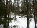
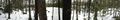
Forrest
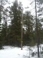
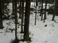
Orienteering
Powerlines

No moose around @59.1641,18.0837
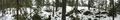
Panorama 1 @59.1641,18.0838
Panorama 2 @59.1641,18.0838
Marker
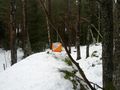
Orange™ marks the spot
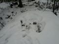
Moose bed
Not the easiest way back
Back at the powerlines
Stable
Abandoned water heater
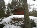
Playhouse
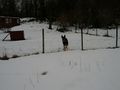
Hey doggy
Those are my tracks, not what the GPS said!


Achievements
Carl-Johan earned the Land geohash achievement
|
Carl-Johan earned the Tron achievement
|
Carl-Johan earned the Police Geohash Achievement
|