Difference between revisions of "2012-02-29 41 -73"
From Geohashing
imported>Jiml m (Adjust result codes) |
imported>FippeBot m (Location) |
||
| Line 63: | Line 63: | ||
[[Category:Expeditions with photos]] | [[Category:Expeditions with photos]] | ||
[[Category:Coordinates reached]] | [[Category:Coordinates reached]] | ||
| + | {{location|US|CT|FA}} | ||
Latest revision as of 02:35, 13 August 2019
| Wed 29 Feb 2012 in 41,-73: 41.3129303, -73.1794689 geohashing.info google osm bing/os kml crox |
Location
North of Bridgeport
Participants
Plans
Expedition
- at the hash point or very close -- NCommander @41.3129,-73.1794 17:47, 29 February 2012 (EST)
Photos
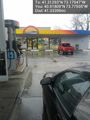
fueling @40.9181,-73.7751
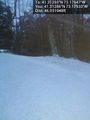
Hash point from the road. Approx 5 to 10 feet @41.3129,-73.1793
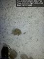
ground zero @41.3129,-73.1794


Achievements
- Land Geohash
- Leap Day