Difference between revisions of "2012-02-29 42 -88"
imported>FireTrophy (→Expedition: expanding story) |
imported>FireTrophy (→Expedition: more expedition) |
||
| Line 35: | Line 35: | ||
== Expedition == | == Expedition == | ||
| − | After speaking with a very polite but confused Farmer Mike, I received his permission to walk out to his cornfield around 7:20 CST. The ground out there was soft and loamy, due to a very mild winter. The | + | After speaking with a very polite but confused Farmer Mike, I received his permission to walk out to his cornfield around 7:20 CST. I don't have a GPS, so I used Google Earth instead. But I couldn't get the tool to report my exact GPS setting. So I estimated where I thought it would be, according to what I looked up earlier. The ground out there was soft and loamy, due to a very mild winter. The weather was kind of cold that night though, and the wind cut quite deeply. I marked the spot with a little note in the dirt explaining the idea of geohashing and a link to the wiki page. |
Then I stopped at the local tavern, where they were having a fish fry night. Good stuff. | Then I stopped at the local tavern, where they were having a fish fry night. Good stuff. | ||
| + | |||
| + | I realize now after the fact that the actual spot was like 200ft to the SE. I still count this as a win, though. | ||
Notes for future expeditions: bring change of shoes. That mud gets everywhere. Also, might be a good idea to bring a reflective vest, just to be more visible and avoid any suspicion. | Notes for future expeditions: bring change of shoes. That mud gets everywhere. Also, might be a good idea to bring a reflective vest, just to be more visible and avoid any suspicion. | ||
Revision as of 07:01, 1 March 2012
| Wed 29 Feb 2012 in 42,-88: 42.3129303, -88.1794689 geohashing.info google osm bing/os kml crox |
Location
Field outside of Volo, IL.
Google maps lists nearest address as 30981 N Fisher Rd, Wauconda, IL 60084. Appears to be in a farmer's field very close to an access road.
Participants
- FireTrophy. This is my first attempt at a geohash!
Plans
Planning to drive out there, to arrive around ~7:30 pm.
Gonna grab some dinner later, there looks to be a place called Bobby's Barrel Inn nearby.
Expedition
After speaking with a very polite but confused Farmer Mike, I received his permission to walk out to his cornfield around 7:20 CST. I don't have a GPS, so I used Google Earth instead. But I couldn't get the tool to report my exact GPS setting. So I estimated where I thought it would be, according to what I looked up earlier. The ground out there was soft and loamy, due to a very mild winter. The weather was kind of cold that night though, and the wind cut quite deeply. I marked the spot with a little note in the dirt explaining the idea of geohashing and a link to the wiki page.
Then I stopped at the local tavern, where they were having a fish fry night. Good stuff.
I realize now after the fact that the actual spot was like 200ft to the SE. I still count this as a win, though.
Notes for future expeditions: bring change of shoes. That mud gets everywhere. Also, might be a good idea to bring a reflective vest, just to be more visible and avoid any suspicion.
Tracklog
N/A
Photos
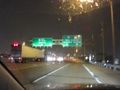
On the way!
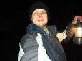
I'm there
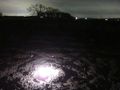
Pleasant, loamy soil at site.
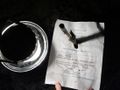
Left note. Don't worry ma'am, we're from the internet.
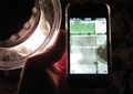
Google Earth - shot from camera
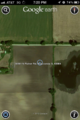
Google Earth - screenshot
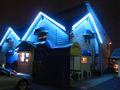
Beer time! Local tavern.
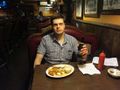
Beer + Fish Fry, delicious.


Achievements
- Land Geohash