Difference between revisions of "2012-03-03 59 17"
imported>Cjk ([live picture] Made it [http://www.openstreetmap.org/?lat=59.32990000&lon=17.81930000&zoom=16&layers=B000FTF @59.3299,17.8193]) |
imported>FippeBot m (Location) |
||
| (5 intermediate revisions by one other user not shown) | |||
| Line 1: | Line 1: | ||
| + | [[Image:{{{image|2012-03-03_59_17_16-13-06-094.jpg}}}|thumb|left]] | ||
| − | |||
| − | |||
| − | |||
| − | |||
| − | |||
| − | |||
| − | |||
| − | |||
| − | |||
{{meetup graticule | {{meetup graticule | ||
| lat=59 | | lat=59 | ||
| Line 19: | Line 11: | ||
== Location == | == Location == | ||
<!-- where you've surveyed the hash to be --> | <!-- where you've surveyed the hash to be --> | ||
| + | 2 km west of the Swedish Stazi in a clear cut part of the woods. | ||
== Participants == | == Participants == | ||
<!-- who attended --> | <!-- who attended --> | ||
| + | *[[User:Cjk|Carl-Johan]] | ||
== Plans == | == Plans == | ||
<!-- what were the original plans --> | <!-- what were the original plans --> | ||
| + | This was just to close to pass up. I thought about biking but I had all the stuff in my car anyway so in the end driving seemed easier. | ||
== Expedition == | == Expedition == | ||
<!-- how it all turned out. your narrative goes here. --> | <!-- how it all turned out. your narrative goes here. --> | ||
| + | I am by law prohibited to describe what I saw 2 km east of the hash. Look on google maps or OSM to see what they call the Swedish Stazi. | ||
| + | After passing the secret place google maps took me on a route that I'm not sure is optimal. It isn't the first time it has taken me on routes that turn into roads you can't legally drive on. As I got close to the shore of this island I got to another protected site, a water treatment plant. Two skaters were on the ice just by the poles in the water fencing of the area. I eventually hit the "no more driving" sign and parked the car and started walking. Walked around the water treatment plant and onto a gravel road. | ||
| + | |||
| + | I was a beautiful spring day and a lot of people walking here. i turned off the road into a clear cut south of it. It was the first time i didn't have my Icebug shoes on and the paths here were frozen so it was very slippery. Found the spot and tried out my new Orange™ which was a bit more yellow, but supposedly this one dries faster and better och weird surfaces. | ||
| + | |||
| + | [[ Image:2012-03-03_59_17_16-13-35-855.jpg | 800px]] | ||
| + | |||
| + | *Stazi is close -- [[User:Cjk|Carl-Johan]] [http://www.openstreetmap.org/?lat=59.32991712&lon=17.81933522&zoom=16&layers=B000FTF @59.3299,17.8193] 16:01, 03 March 2012 (CET) | ||
| + | |||
| + | Snapped some pics and returned to the car. I took a more direct route home to the city. | ||
| − | |||
== Tracklog == | == Tracklog == | ||
<!-- if your GPS device keeps a log, you may post a link here --> | <!-- if your GPS device keeps a log, you may post a link here --> | ||
| + | [http://maps.google.com/maps/ms?msa=0&msid=209560846421673743077.0004ba594d94d56c90cb0 map] | ||
== Photos == | == Photos == | ||
| Line 44: | Line 49: | ||
Image:2012-03-03_59_17_16-08-18-742.jpg | [http://www.openstreetmap.org/?lat=59.33120000&lon=17.86030000&zoom=16&layers=B000FTF @59.3312,17.8603] | Image:2012-03-03_59_17_16-08-18-742.jpg | [http://www.openstreetmap.org/?lat=59.33120000&lon=17.86030000&zoom=16&layers=B000FTF @59.3312,17.8603] | ||
| − | Image:2012-03-03_59_17_16-08-37-318.jpg | | + | Image:2012-03-03_59_17_16-08-37-318.jpg | Prohibited by law to photograph or describe the object [http://www.openstreetmap.org/?lat=59.33160000&lon=17.85680000&zoom=16&layers=B000FTF @59.3316,17.8568] |
Image:2012-03-03_59_17_16-09-03-563.jpg | [http://www.openstreetmap.org/?lat=59.32600000&lon=17.80850000&zoom=16&layers=B000FTF @59.3260,17.8085] | Image:2012-03-03_59_17_16-09-03-563.jpg | [http://www.openstreetmap.org/?lat=59.32600000&lon=17.80850000&zoom=16&layers=B000FTF @59.3260,17.8085] | ||
| Line 52: | Line 57: | ||
Image:2012-03-03_59_17_16-10-38-122.jpg | End of line for cars [http://www.openstreetmap.org/?lat=59.32880000&lon=17.80970000&zoom=16&layers=B000FTF @59.3288,17.8097] | Image:2012-03-03_59_17_16-10-38-122.jpg | End of line for cars [http://www.openstreetmap.org/?lat=59.32880000&lon=17.80970000&zoom=16&layers=B000FTF @59.3288,17.8097] | ||
| − | Image:2012-03-03_59_17_16-11-31-415.jpg | Water treatment plant. Put LSD [http://www.openstreetmap.org/?lat=59.32860000&lon=17.81140000&zoom=16&layers=B000FTF @59.3286,17.8114] | + | Image:2012-03-03_59_17_16-11-31-415.jpg | Water treatment plant. Put LSD in there. [http://www.openstreetmap.org/?lat=59.32860000&lon=17.81140000&zoom=16&layers=B000FTF @59.3286,17.8114] |
Image:2012-03-03_59_17_16-12-22-829.jpg | Over there [http://www.openstreetmap.org/?lat=59.33050000&lon=17.81730000&zoom=16&layers=B000FTF @59.3305,17.8173] | Image:2012-03-03_59_17_16-12-22-829.jpg | Over there [http://www.openstreetmap.org/?lat=59.33050000&lon=17.81730000&zoom=16&layers=B000FTF @59.3305,17.8173] | ||
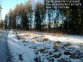
Image:2012-03-03_59_17_16-13-06-094.jpg | Made it [http://www.openstreetmap.org/?lat=59.32990000&lon=17.81930000&zoom=16&layers=B000FTF @59.3299,17.8193] | Image:2012-03-03_59_17_16-13-06-094.jpg | Made it [http://www.openstreetmap.org/?lat=59.32990000&lon=17.81930000&zoom=16&layers=B000FTF @59.3299,17.8193] | ||
| + | |||
| + | Image:2012-03-03_59_17_16-13-35-855.jpg | Panorama 1 [http://www.openstreetmap.org/?lat=59.33013526&lon=17.81967435&zoom=16&layers=B000FTF @59.3301,17.8197] | ||
| + | |||
| + | Image:2012-03-03_59_17_16-15-43-739.jpg | Panorama 2 [http://www.openstreetmap.org/?lat=59.33061961&lon=17.81779261&zoom=16&layers=B000FTF @59.3306,17.8178] | ||
| + | |||
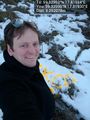
| + | Image:2012-03-03_59_17_16-15-15-773.jpg | New Orange™ marker [http://www.openstreetmap.org/?lat=59.33010000&lon=17.81930000&zoom=16&layers=B000FTF @59.3301,17.8193] | ||
</gallery> | </gallery> | ||
| Line 62: | Line 73: | ||
{{#vardefine:ribbonwidth|800px}} | {{#vardefine:ribbonwidth|800px}} | ||
<!-- Add any achievement ribbons you earned below, or remove this section --> | <!-- Add any achievement ribbons you earned below, or remove this section --> | ||
| − | + | {{land geohash | latitude = 59 | longitude = 17 | date = 2012-03-03 | name = [[User:Cjk|Carl-Johan]] }} | |
<!-- =============== USEFUL CATEGORIES FOLLOW ================ | <!-- =============== USEFUL CATEGORIES FOLLOW ================ | ||
Delete the next line ONLY if you have chosen the appropriate categories below. If you are unsure, don't worry. People will read your report and help you with the classification. --> | Delete the next line ONLY if you have chosen the appropriate categories below. If you are unsure, don't worry. People will read your report and help you with the classification. --> | ||
| − | |||
<!-- Potential categories. Please include all the ones appropriate to your expedition --> | <!-- Potential categories. Please include all the ones appropriate to your expedition --> | ||
| Line 74: | Line 84: | ||
<!-- An actual expedition: | <!-- An actual expedition: | ||
| − | |||
-- and one or more of -- | -- and one or more of -- | ||
| − | + | [Category:Expeditions with videos]] | |
| − | |||
[[Category:Expedition without GPS]] | [[Category:Expedition without GPS]] | ||
--> | --> | ||
| − | + | [[Category:Expeditions]] | |
| + | [[Category:Expeditions with photos]] | ||
| + | [[Category:Coordinates reached]] | ||
| + | |||
<!-- if you reached your coords: | <!-- if you reached your coords: | ||
| − | |||
--> | --> | ||
| Line 93: | Line 103: | ||
[[Category:Not reached - Did not attempt]] when you went to an alternate location, or decided early on to abort the expedition. | [[Category:Not reached - Did not attempt]] when you went to an alternate location, or decided early on to abort the expedition. | ||
--> | --> | ||
| + | {{location|SE|AB}} | ||
Latest revision as of 02:42, 13 August 2019

| Sat 3 Mar 2012 in 59,17: 59.3299215, 17.8193385 geohashing.info google osm bing/os kml crox |
Location
2 km west of the Swedish Stazi in a clear cut part of the woods.
Participants
Plans
This was just to close to pass up. I thought about biking but I had all the stuff in my car anyway so in the end driving seemed easier.
Expedition
I am by law prohibited to describe what I saw 2 km east of the hash. Look on google maps or OSM to see what they call the Swedish Stazi.
After passing the secret place google maps took me on a route that I'm not sure is optimal. It isn't the first time it has taken me on routes that turn into roads you can't legally drive on. As I got close to the shore of this island I got to another protected site, a water treatment plant. Two skaters were on the ice just by the poles in the water fencing of the area. I eventually hit the "no more driving" sign and parked the car and started walking. Walked around the water treatment plant and onto a gravel road.
I was a beautiful spring day and a lot of people walking here. i turned off the road into a clear cut south of it. It was the first time i didn't have my Icebug shoes on and the paths here were frozen so it was very slippery. Found the spot and tried out my new Orange™ which was a bit more yellow, but supposedly this one dries faster and better och weird surfaces.

- Stazi is close -- Carl-Johan @59.3299,17.8193 16:01, 03 March 2012 (CET)
Snapped some pics and returned to the car. I took a more direct route home to the city.
Tracklog
Photos
Prohibited by law to photograph or describe the object @59.3316,17.8568
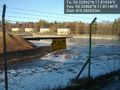
No diving @59.3278,17.8061
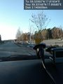
End of line for cars @59.3288,17.8097
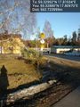
Water treatment plant. Put LSD in there. @59.3286,17.8114
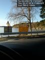
Over there @59.3305,17.8173
Made it @59.3299,17.8193
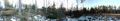
Panorama 1 @59.3301,17.8197

Panorama 2 @59.3306,17.8178
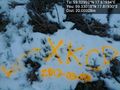
New Orange™ marker @59.3301,17.8193


Achievements
Carl-Johan earned the Land geohash achievement
|