Difference between revisions of "2012-03-06 53 -2"
imported>Alexturgid (→Tracklog) |
imported>FippeBot m (Location) |
||
| (13 intermediate revisions by 3 users not shown) | |||
| Line 2: | Line 2: | ||
--> | --> | ||
{{meetup graticule | {{meetup graticule | ||
| − | | lat=53 | + | | lat=53 |
| − | | lon=-2 | + | | lon=-2 |
| date=2012-03-06 | | date=2012-03-06 | ||
}} | }} | ||
| − | + | ||
__NOTOC__ | __NOTOC__ | ||
== Location == | == Location == | ||
| Line 19: | Line 19: | ||
== Plans == | == Plans == | ||
| − | [[User:Alexturgid|Alexturgid]] and his friend [[User:Tekwyzard|Ken]], whose plan was to just survive the journey, cycle to the hash, setting off at 1830 UK time from [ | + | [[User:Alexturgid|Alexturgid]] and his friend [[User:Tekwyzard|Ken]], whose plan was to just survive the journey, cycle to the hash, setting off at 1830 UK time from [http://maps.google.co.uk/?ll=53.747666,-2.482969&spn=0.001172,0.00284&t=h&z=19 53.747666, -2.482969]. They planned to arrive before 2000. |
== Expedition == | == Expedition == | ||
| Line 25: | Line 25: | ||
The team met at [http://maps.google.co.uk/?ll=53.747666,-2.482969&spn=0.001172,0.00284&t=h&z=19 The Big Ball], Astley Gate, Blackburn at 1830 UK time and set off in the direction of the hash. Alexturgid's local knowledge took the expedition through Rishton, Clayton-Le-Moors, Altham and Highem as far as [http://maps.google.co.uk/?ll=53.843083,-2.218391&spn=0.004678,0.011362&t=m&z=17 Barrowford] but the team needed the expert assistance of Google Navigation to circumvent M65 Junction 12 and further to Foulridge Upper Reservoir, where the hash was to be found. | The team met at [http://maps.google.co.uk/?ll=53.747666,-2.482969&spn=0.001172,0.00284&t=h&z=19 The Big Ball], Astley Gate, Blackburn at 1830 UK time and set off in the direction of the hash. Alexturgid's local knowledge took the expedition through Rishton, Clayton-Le-Moors, Altham and Highem as far as [http://maps.google.co.uk/?ll=53.843083,-2.218391&spn=0.004678,0.011362&t=m&z=17 Barrowford] but the team needed the expert assistance of Google Navigation to circumvent M65 Junction 12 and further to Foulridge Upper Reservoir, where the hash was to be found. | ||
| − | As predicted with the use of Google Street View, a public footpath off Brownhill Lane provided access to the hash and after hoiking the lightcycles over a couple of stiles and performing the traditional "wander of | + | As predicted with the use of Google Street View, a public footpath off Brownhill Lane provided access to the hash and after hoiking the lightcycles over a couple of stiles and performing the traditional GPS "wander of hope" through the field, the hash was found. |
During the journey, Ken had been telling Alexturgid about his experience doing full nude life modelling at a studio up the road in Kelbrook. It would of course have been remiss of Alexturgid not to inform Ken of the [[Geoflashing]] achievement. So he did, and they did. | During the journey, Ken had been telling Alexturgid about his experience doing full nude life modelling at a studio up the road in Kelbrook. It would of course have been remiss of Alexturgid not to inform Ken of the [[Geoflashing]] achievement. So he did, and they did. | ||
| Line 33: | Line 33: | ||
<blockquote><p><i>"I'm glad I can balance using my bike cos otherwise I'd be on my arse in cow shiiiiiiiiiiiiiiiiiiiiii" *thud* </i></p></blockquote> | <blockquote><p><i>"I'm glad I can balance using my bike cos otherwise I'd be on my arse in cow shiiiiiiiiiiiiiiiiiiiiii" *thud* </i></p></blockquote> | ||
| − | At the end of the path, the (now very muddy) cyclists remounted and returned via road to The Big Ball, this time on the south side of the M65, passing through Nelson, Burnley and Accrington, wherein alcoholic beverages were purchased and conveyed hence. Journey complete, [[Tron achievement]] in hand, the team returned to Alexturgid's flat to consume previously mentioned beverages. | + | closely followed by the coughing and spluttering, of Ken nearly suffering death by laughing and biscuit. |
| + | |||
| + | At the end of the path, the (now very muddy, but recomposed) cyclists remounted and returned via road to The Big Ball, this time on the south side of the M65, passing through Nelson, Burnley and Accrington, wherein alcoholic beverages were purchased and conveyed hence. Journey complete, [[Tron achievement]] in hand, the team returned to Alexturgid's flat to consume previously mentioned beverages. | ||
== Tracklog == | == Tracklog == | ||
| Line 43: | Line 45: | ||
== Photos == | == Photos == | ||
| − | |||
| − | |||
| − | |||
| − | |||
<gallery perrow="5"> | <gallery perrow="5"> | ||
| + | Image:2012-03-06 53 -2 Alexwithgps.jpg | [[User:Alexturgid|Alexturgid]] at the hash | ||
| + | Image:2012-03-06 53 -2 Kenwithgps.jpg | [[User:Tekwyzard|Tekwyzard]] at the hash | ||
| + | Image:Nekkid.jpg | Yep. | ||
| + | Image:Cowpooarse.jpg | Not just mud. | ||
Image:Bigballandbikes.jpg | The Big Ball: Expedition Complete. | Image:Bigballandbikes.jpg | The Big Ball: Expedition Complete. | ||
| − | |||
| − | |||
</gallery> | </gallery> | ||
| Line 59: | Line 59: | ||
| longitude = -2 | | longitude = -2 | ||
| date = 2012-03-06 | | date = 2012-03-06 | ||
| + | | name = [[User:Alexturgid|Alexturgid]] and [[User:Tekwyzard|Tekwyzard]] | ||
}} | }} | ||
| Line 66: | Line 67: | ||
| date = 2012-03-06 | | date = 2012-03-06 | ||
| distance = 60.75km | | distance = 60.75km | ||
| + | | name = [[User:Alexturgid|Alexturgid]] and [[User:Tekwyzard|Tekwyzard]] | ||
}} | }} | ||
| Line 74: | Line 76: | ||
| tracklog = http://runkeeper.com/user/alexturgid/activity/74028791?&mobile=false | | tracklog = http://runkeeper.com/user/alexturgid/activity/74028791?&mobile=false | ||
| possessive = their | | possessive = their | ||
| + | | name = [[User:Alexturgid|Alexturgid]] and [[User:Tekwyzard|Tekwyzard]] | ||
}} | }} | ||
| Line 80: | Line 83: | ||
| longitude = -2 | | longitude = -2 | ||
| date = 2012-03-06 | | date = 2012-03-06 | ||
| + | | name = [[User:Alexturgid|Alexturgid]] and [[User:Tekwyzard|Tekwyzard]] | ||
}} | }} | ||
| − | + | ||
| − | |||
| − | |||
[[Category:Expeditions]] | [[Category:Expeditions]] | ||
| + | [[Category:Expeditions with photos]] | ||
| + | |||
<!-- and one or more of -- | <!-- and one or more of -- | ||
| − | |||
[[Category:Expeditions with videos]] | [[Category:Expeditions with videos]] | ||
[[Category:Expedition without GPS]] | [[Category:Expedition without GPS]] | ||
| Line 95: | Line 98: | ||
[[Category:Coordinates reached]] | [[Category:Coordinates reached]] | ||
| + | {{location|GB|ENG|LAN}} | ||
Latest revision as of 02:45, 13 August 2019
| Tue 6 Mar 2012 in 53,-2: 53.8664696, -2.1576538 geohashing.info google osm bing/os kml crox |
Location
The hash is by Foulridge Upper Reservoir, near Colne in Lancashire, and seems to be accessible via a public footpath off Brownhill Lane.
Participants
Plans
Alexturgid and his friend Ken, whose plan was to just survive the journey, cycle to the hash, setting off at 1830 UK time from 53.747666, -2.482969. They planned to arrive before 2000.
Expedition
The team met at The Big Ball, Astley Gate, Blackburn at 1830 UK time and set off in the direction of the hash. Alexturgid's local knowledge took the expedition through Rishton, Clayton-Le-Moors, Altham and Highem as far as Barrowford but the team needed the expert assistance of Google Navigation to circumvent M65 Junction 12 and further to Foulridge Upper Reservoir, where the hash was to be found.
As predicted with the use of Google Street View, a public footpath off Brownhill Lane provided access to the hash and after hoiking the lightcycles over a couple of stiles and performing the traditional GPS "wander of hope" through the field, the hash was found.
During the journey, Ken had been telling Alexturgid about his experience doing full nude life modelling at a studio up the road in Kelbrook. It would of course have been remiss of Alexturgid not to inform Ken of the Geoflashing achievement. So he did, and they did.
Reclothed, the team made egress from the field while being careful not to cross their own track and proceeded along another footpath, which after a couple of stiles became a muddy cattle run. At this stage, while walking his bike through the mud, Alexturgid uttered the Quote of the Day:
"I'm glad I can balance using my bike cos otherwise I'd be on my arse in cow shiiiiiiiiiiiiiiiiiiiiii" *thud*
closely followed by the coughing and spluttering, of Ken nearly suffering death by laughing and biscuit.
At the end of the path, the (now very muddy, but recomposed) cyclists remounted and returned via road to The Big Ball, this time on the south side of the M65, passing through Nelson, Burnley and Accrington, wherein alcoholic beverages were purchased and conveyed hence. Journey complete, Tron achievement in hand, the team returned to Alexturgid's flat to consume previously mentioned beverages.
Tracklog
Runkeeper Log, with elevation and speed profile.
Total journey: 37.75mi (60.75km) in 3h09m09s, climb of 2463ft (751m)
Photos
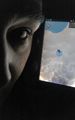
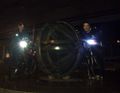
Alexturgid at the hash
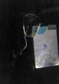
Tekwyzard at the hash
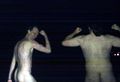
Yep.
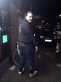
Not just mud.
The Big Ball: Expedition Complete.


Achievements
Alexturgid and Tekwyzard earned the Land geohash achievement
|
Alexturgid and Tekwyzard earned the Bicycle geohash achievement
|
Alexturgid and Tekwyzard earned the Tron achievement
|
Alexturgid and Tekwyzard earned the Geoflashing Achievement
|