Difference between revisions of "2012-03-12 45 -122"
From Geohashing
imported>Michael5000 m (→Participants) |
imported>FippeBot m (Location) |
||
| (3 intermediate revisions by 2 users not shown) | |||
| Line 1: | Line 1: | ||
| − | |||
<!-- If you did not specify these parameters in the template, please substitute appropriate values for IMAGE, LAT, LON, and DATE (YYYY-MM-DD format) | <!-- If you did not specify these parameters in the template, please substitute appropriate values for IMAGE, LAT, LON, and DATE (YYYY-MM-DD format) | ||
| Line 25: | Line 24: | ||
[[User:Michael5000|Michael5000]] | [[User:Michael5000|Michael5000]] | ||
| − | == | + | == Expedition == |
| − | |||
| − | + | This location didn't look very promising from the aerial imagery, but it was enough not out-of-the-way that I gave it the old college try. It was solidly on the inside of the block, however, and I wasn't able to get closer than 121 feet or to get a line of sight to the hashpoint. | |
| − | |||
| − | + | Expedition Thwarted. | |
| − | |||
== Photos == | == Photos == | ||
| Line 39: | Line 35: | ||
--> | --> | ||
<gallery perrow="5"> | <gallery perrow="5"> | ||
| + | File:2012-03-12 45 -122 Sign.JPG|I got as far as here. | ||
| + | File:2012-03-12 45 -122 Fence.JPG|I had kind of hoped I'd be able to go through here. | ||
| + | File:2012-03-12 45 -122 House.JPG|If you lived here, you'd already have the Couch Potato Achievement. | ||
</gallery> | </gallery> | ||
| Line 45: | Line 44: | ||
<!-- Add any achievement ribbons you earned below, or remove this section --> | <!-- Add any achievement ribbons you earned below, or remove this section --> | ||
| + | {{No trespassing | ||
| + | | latitude = 45 | ||
| + | | longitude = -122 | ||
| + | | date = 2012-03-12 | ||
| + | | name = Michael5000 | ||
| + | }} | ||
| − | |||
| − | |||
| − | |||
| − | |||
| − | |||
| − | |||
| − | |||
| − | |||
| − | |||
| − | |||
[[Category:Expeditions]] | [[Category:Expeditions]] | ||
| − | |||
[[Category:Expeditions with photos]] | [[Category:Expeditions with photos]] | ||
| − | [[Category: | + | [[Category:Not reached - No public access]] |
| − | |||
| − | |||
| − | |||
| − | |||
| − | |||
| − | |||
| − | |||
| − | |||
[[Category:Coordinates not reached]] | [[Category:Coordinates not reached]] | ||
| − | + | {{location|US|OR|MU}} | |
| − | |||
| − | |||
| − | |||
| − | |||
| − | |||
Latest revision as of 02:52, 13 August 2019
| Mon 12 Mar 2012 in 45,-122: 45.4935540, -122.5284887 geohashing.info google osm bing/os kml crox |
Location
In a backyard near Powell Boulevard in Southeast Portland.
Participants
Expedition
This location didn't look very promising from the aerial imagery, but it was enough not out-of-the-way that I gave it the old college try. It was solidly on the inside of the block, however, and I wasn't able to get closer than 121 feet or to get a line of sight to the hashpoint.
Expedition Thwarted.
Photos
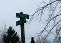
I got as far as here.
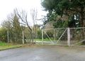
I had kind of hoped I'd be able to go through here.
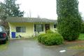
If you lived here, you'd already have the Couch Potato Achievement.


Achievements
Michael5000 earned the No trespassing consolation prize
|