Difference between revisions of "2012-03-13 34 -89"
imported>MayorOfBoxTown (→Achievements) |
imported>GeorgDerReisende |
||
| Line 1: | Line 1: | ||
| − | |||
| − | |||
| − | |||
| − | |||
| − | |||
| − | |||
| − | |||
| − | |||
| − | |||
{{meetup graticule | {{meetup graticule | ||
| lat=34 | | lat=34 | ||
| Line 58: | Line 49: | ||
| − | |||
| − | |||
| − | |||
| − | |||
| − | |||
| − | |||
[[Category:Expeditions]] | [[Category:Expeditions]] | ||
[[Category:Expeditions with photos]] | [[Category:Expeditions with photos]] | ||
[[Category:Coordinates not reached]] | [[Category:Coordinates not reached]] | ||
[[Category:Not reached - No public access]] | [[Category:Not reached - No public access]] | ||
Revision as of 21:23, 11 November 2014
| Tue 13 Mar 2012 in 34,-89: 34.9469397, -89.6392158 geohashing.info google osm bing/os kml crox |
Location
In some woods across from a cemetery!
Participants
Plans
Going to drive by after work to see if it's on private property, and if not, come back later fully prepared...
Expedition
It was private property... :(
Mayor drove down after work. It was pretty easy to find. There was a fence about ten yards south of the road, and it had private property signs every 100ft or so. The hash was a stone's throw past the fence, so there wasn't really any point going around the property to check it out some more.
Google maps showed a cemetery nearby, so I thought I'd check it out. I drove past a really shady looking driveway and then... wait. That was the cemetery?? I changed my mind quickly; I did not want to check it out. I instead drove home quickly.
Also there was a discarded toilet on the side of the road. Yaaayyy Mississippi.
Photos
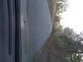
The road there.
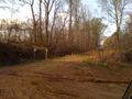
The cemetery. Part of me wishes I had ventured in.
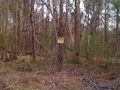
The proof of failure.


Achievements
MayorOfBoxTown earned the No trespassing consolation prize
|