Difference between revisions of "2012-03-18 -37 145"
imported>Kozz (→Kozz) |
imported>Kozz |
||
| Line 61: | Line 61: | ||
Image:2012-03-18_-37_145_11-24-39-138.jpg | Ponds nearby | Image:2012-03-18_-37_145_11-24-39-138.jpg | Ponds nearby | ||
| − | + | Image:2012-03-18_-37_145_21-15-32-110.jpg | Norton Park | |
| − | |||
| − | Image:2012-03-18_-37_145_21-15-32-110.jpg | | ||
Image:2012-03-18_-37_145_21-16-24-486.jpg | Kozz's dog | Image:2012-03-18_-37_145_21-16-24-486.jpg | Kozz's dog | ||
| Line 92: | Line 90: | ||
Image:2012-03-18_-37_145_19-38-09-130.jpg | [http://www.openstreetmap.org/?lat=-37.83546550&lon=145.09160360&zoom=16&layers=B000FTF @-37.8355,145.0916] | Image:2012-03-18_-37_145_19-38-09-130.jpg | [http://www.openstreetmap.org/?lat=-37.83546550&lon=145.09160360&zoom=16&layers=B000FTF @-37.8355,145.0916] | ||
| + | |||
| + | Image:2012-03-18_-37_145_19-38-51-874.jpg | | ||
</gallery> | </gallery> | ||
| Line 99: | Line 99: | ||
<!-- Add any achievement ribbons you earned below, or remove this section --> | <!-- Add any achievement ribbons you earned below, or remove this section --> | ||
| − | |||
| − | |||
| − | |||
[[Category:New report]] | [[Category:New report]] | ||
| − | |||
| − | |||
| − | |||
| − | |||
| − | |||
| − | |||
| − | |||
[[Category:Expeditions]] | [[Category:Expeditions]] | ||
| − | |||
[[Category:Expeditions with photos]] | [[Category:Expeditions with photos]] | ||
| − | + | ||
| − | |||
| − | |||
| − | |||
| − | |||
[[Category:Coordinates reached]] | [[Category:Coordinates reached]] | ||
| − | |||
| − | |||
| − | |||
| − | |||
| − | |||
| − | |||
| − | |||
| − | |||
| − | |||
| − | |||
Revision as of 10:21, 18 March 2012
| Sun 18 Mar 2012 in -37,145: -37.8819343, 145.1932346 geohashing.info google osm bing/os kml crox |
Location
Participants
Plans
Kozz took his family for a walk at the hashpoint. Myka and Ez will be heading out after lunch, to have a look around
Kozz
Kozz: I spotted this last night and not seeing a grat page decided to do an in & out mission to Shepherd's Bush. The dog was an automatic +1, especially given there's an offlead area like 200m from the hashpoint, and I am familiar with the area as I frequently run up and down the EastLink Trail which is a few hundred metres away. Surprisingly, the wife and child decided to come along which, in combo with the dog, negated the possibility of a Run, Walk or Cycle hash.
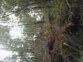
We navigated in from Norton's Park and found the hashpoint - like Felix below, it seemed to think said hashpoint was on a well-formed trail in the middle of Shepherd's Bush, but the phone was jumping about 20 metres on each resync and wouldn't settle down, so I figure within the 10metre boundary would've been close. The phone initially said the hashpoint was right in the middle of the river - judging from Felix & Stevage's photos it was probably 5 metres up a bank off the trail. Anyway. Solid hash!
The whole area is awesome, there are bike paths (the Eastlink & Jells Park trail) nearby so very well habited. Glad to see there was a good turnout especially on a sports-packed day (Formula 1 + Rebels game)
Not sure when Myka & Ez got there but from the looks of the photos it wasn't much later than the Kozzezes. Next time, mate.
Felix Dance & Stevage
Apparently there were two expeditions! Oops. Felix Dance and Stevage cycled there, arriving around 4:45pm. Taking a navigationally suboptimal route, we found ourselves on the wrong side of the creek. Probably the most efficient thing to do would be to ride to the nearest bridge and back. Instead, we availed ourselves of a fallen log suspended over the creek.
Foolishly I couldn't find my GPS and had to rely on my phone. It said the point was basically right on the path. Felix's GPS didn't really settle down and seemed to be pointing into the bushes. We shrugged, took our photos, and headed back over the log of doom.
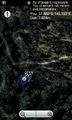
Tracklog
Photos
Kozz
Reached!
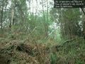
Hashpoint location
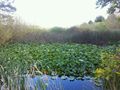
Ponds nearby
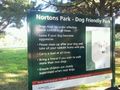
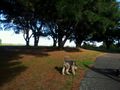
Norton Park
Kozz's dog
Exact same pice as Myka!


Myka
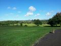
Arrived at Norton park. The hash is down that way @-37.8792,145.1988
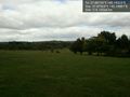
Retreating kozz' the hash photo @-37.8820,145.1930


