Difference between revisions of "2012-03-19 53 -2"
From Geohashing
imported>Angel m (→Tracklog: link currently broken ... will be fixed at some point in the near future) |
imported>FippeBot m (Location) |
||
| Line 42: | Line 42: | ||
[[Category:Coordinates reached]] | [[Category:Coordinates reached]] | ||
| + | {{location|GB|ENG|SHN}} | ||
Latest revision as of 03:03, 13 August 2019

| Mon 19 Mar 2012 in 53,-2: 53.4556227, -2.7159722 geohashing.info google osm bing/os kml crox |
Location
Waine Street, St Helens.
Participants
Plans
Angel will walk from nearby Up Holland, going via Billinge. The shortest route is 7.5 miles, while this route is 8.2. However, the shorter route really isn't safe for pedestrians, so the extra mileage should bhe worth it. I'm expecting to arrive some time around 12, and maybe get lunch nearby, if anyone wants to join me.
Expedition
Only took 2 hours; that's pretty impressive. Took a little detour (the 'scenic route'), but otherwise followed the route I'd planned. Got a photo, then went off to KFC for lunch.
Tracklog
[1] - courtesy of CardioTrainer
- Link is now broken because of server failure; not removed because I'm currently in the process of sifting through backups. Is the "Expeditions without GPS" category still necessary? -- Angel (talk) 05:16, 30 January 2014 (EST)
Photos
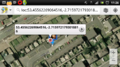
Hope those coords are right
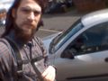
Is that the same car from the satellite view?
